


Summary
Prawet (Thai: ประเวศ, pronounced [prā.wêːt]) is one of the 50 districts of Bangkok, Thailand. It is in the southeast. Neighboring districts are (from the east clockwise) Bang Phli (Samut Prakan province), Bang Na, Phra Khanong, Suan Luang, Bang Kapi, Saphan Sung and Lat Krabang (Bangkok).
Prawet
ประเวศ | |
|---|---|
 | |
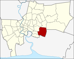 Khet location in Bangkok | |
| Coordinates: 13°43′1″N 100°41′40″E / 13.71694°N 100.69444°E | |
| Country | Thailand |
| Province | Bangkok |
| Seat | Prawet |
| Khwaeng | 3 |
| Khet established | 9 November 1989 |
| Area | |
| • Total | 52.490 km2 (20.267 sq mi) |
| Population (2017) | |
| • Total | 175,656[1] |
| • Density | 3,346.47/km2 (8,667.3/sq mi) |
| Time zone | UTC+7 (ICT) |
| Postal code | 10250 (Dokmai, Mu 2-10 of Nong Bon: 10260) |
| Geocode | 1032 |
History edit
Prawet was once part of Phra Khanong District. Prawet was elevated to become a separate district in 1989. Part of Prawet, especially the Suan Luang Sub-district, was carved out to establish Suan Luang District on 14 January 1994.
Its name after Khlong Prawet Burirom, a canal that flows through the northern area.
In October 2005 the plan to create the special administrative area Nakhon Suvarnabhumi around the new Bangkok airport became public. Prawet was supposed to be one of five districts to be included in this new area.
Administration edit
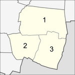
The district is sub-divided into three sub-districts (khwaeng).
| No. | Name | Thai | Area (km2) |
Map |
|---|---|---|---|---|
1. |
Prawet | ประเวศ | 22.805 |
|
2. |
Nong Bon | หนองบอน | 14.513
| |
3. |
Dokmai | ดอกไม้ | 15.172
| |
| Total | 52.490
| |||
Motto edit
The district's motto is "Prawet is green and shady, of particular note is Suan Luang Rama IX, the open university inculcates high moral values and helps to develop model citizens".
Places edit
Education edit
- Pan-Asia International School[2]
- Wells International School (Wells International Kindergarten Bangna Campus)[3]
Place of worship edit
- Masjid Assa'adah
- Wat Kaeo Phithak Charoen Tham
- Wat Krathum Suea Pla
- Wat Taklam
- Yami Ul Ibadah (also known as Masjid Ban Tang Khawi)[4]
Public park edit
- Chaloem Phrakiat Mahat Thai Park
- Nong Bon Water Sports Center
- PTT Metro Forest Learning Center
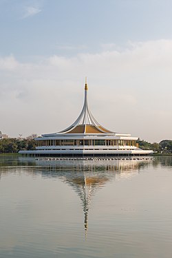
- Suan Luang Rama IX
- Suan Wanatham Park
Shopping center edit
- Paradise Park (formerly Seri Center)
- Seacon Square
- Srinagarindra Train Night Market
Transportation edit
Srinagarindra Road is a main artery of the district, Chaloem Phra Kiat Ratchakan Thi 9 and Phatthanakan with On Nut (Sukhumvit 77) as well as Sukhaphiban 2 Roads considered as a minor road. Kanchanaphisek Road (Outer Ring Road) passes through the eastern area. Prawet is served by Ban Thap Chang Station of the State Railway of Thailand, whose eastern line and airport rail link runs past the area.
References edit
- ^ "Population and House Report for Year 2017 (see page 2 for data of this district)". Department of Provincial Administration, Ministry of Internal Affairs. Retrieved 1 April 2018. (Search page)
- ^ "About Us". Pan-Asia International School. Retrieved 18 January 2020.
- ^ "Bang Na Campus". Wells International School. Retrieved 18 January 2020.
- ^ Svasti, Pichaya (7 September 2017). "A tale of two canals". Bangkok Post. Retrieved 31 December 2020.
External links edit
- Official website of the district (Thai)
- BMA website with the tourist landmarks of Prawet
- Suan Luang Rama IX