


Summary
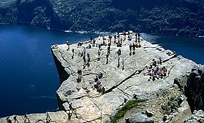
Preikestolen or Prekestolen (English: 'The Pulpit Rock', 'Pulpit', or 'Preacher's Chair') is a tourist attraction in the municipality of Strand in Rogaland county, Norway. Preikestolen is a steep cliff which rises 604 metres (1,982 ft) above Lysefjorden. Atop the cliff, there is an almost flat top of approximately 25 by 25 metres (82 ft × 82 ft). Preikestolen is located near the Western part of the fjord, and on its North side.
| Preikestolen | |
|---|---|
| Prekestolen | |
 Preikestolen overlooking Lysefjorden | |
| Highest point | |
| Elevation | 604 m (1,982 ft) |
| Coordinates | 58°59′07″N 6°11′03″E / 58.9852°N 6.1843°E[1] |
| Geography | |
 Preikestolen Location of the mountain  Preikestolen Preikestolen (Norway) | |
| Location | Rogaland, Norway |
| Topo map | 1313 III Lyngsvatnet |
| Geology | |
| Mountain type | Granite |
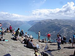
Tourism at the site has been increasing in the early 21st century, with between 150,000 and 200,000 visitors in 2012,[2] making it one of the most visited natural tourist attractions in Norway. BASE jumpers often leap from the cliff. Due to its increased popularity, the most used path to the site (a 3.8-kilometre (2.4 mi) long hike) was improved by Nepalese Sherpas in 2013.[3]
Name edit
The old local name of the site is Hyvlatonnå; English: (woodworker's) Plane's Tooth. The name Prekestolen (without the i) was coined around the year 1900 when the local tourist organisation, Stavanger Turistforening, wanted to promote the site for trekking. The "i" was added later to concord with Nynorsk, the official local form of Norwegian, and the site is now known both locally and officially as "Preikestolen."

Access edit


Preikestolen is located in the southern part of the Ryfylke district in Rogaland county in Western Norway. The city of Stavanger, the fourth largest in Norway, with a number of direct flights to/from European cities, is located 25 kilometres (16 mi) from the site. The parking facility for Preikestolen is located, thanks to the April 2020 opening of underwater tunnel Ryfylketunnelen, about 40 minutes from Stavanger by car.
Access to Preikestolen from Stavanger is via the Norwegian National Road 13 (Rv13). From the south, it is possible to drive to the Preikestolen parking facility via the ferry from Lauvvika to Oanes. Ferries run year-round, but have limited hours, so plan ahead if opting for ferry over tunnel.
The road to the site ends in the municipality of Strand, just south of the town of Jørpeland at a parking facility at the Preikestolen Fjellstue, with a trail extending from the parking facility to the site. A round-trip hike to Preikestolen from the closest car park takes about 3–4 hours for someone of average fitness.[4]
The walk to Preikestolen is very steep in places. The path starts at the Preikestolhytta, at an elevation of approximately 270 metres (890 ft) above sea level, and climbs to 604 metres (1,982 ft). The walk takes 2–3 hours depending on traffic along the trail, experience, and fitness level. Even though the elevation differential is only 334 metres (1,096 ft) and the walk is not particularly long, about 3.8 kilometres (2.4 mi) each way, the total elevation gain and loss over the course of the hike is more than one might initially expect, as the path climbs and descends various ridges. The walk is more difficult in winter and spring when there is snow and ice. Due to snow, it is not always possible to do the hike to the top in the winter.[5]
Alternative access is available via a path from Bratteli – a stop for the tourist ferry from Lauvvik to Lysebotn that passes beneath the Pulpit Rock. This walk is more demanding, and takes 4–5 hours each way.[6]
An alternative is to sail through the Lysefjorden, with trips running year-round. Outside of summer, the weather may be wet and cold, and clouds may obstruct views of the cliff.[citation needed] The ship stops at several small docks on the way in and out, including a layover at the end of the Lysefjorden at the village of Lysebotn.[7][8]
Improvement project edit
In early April 2013, a project started to improve the path up to Preikestolen as the old one was so small that it often caused "delays", and at some points on the path it was sometimes impossible to get through. By 2016 the path was completed.[9]
In 2019 a new project started to further improve paths, new website and improvement of signs.[10]

Safety edit
The authorities have opted not to install fencing or other safety devices as they felt it would detract from the site and the fact that fatalities at the site are extremely rare, despite having approximately 200,000 visitors each year.[11] Furthermore, there were concerns that fences or other devices might encourage dangerous behavior such as climbing onto the fences. Norwegian authorities have stated that "we cannot fence in all nature in this country".[12]
Up until 2013 there had been no accidental fatalities at the site. However, there were previously suicide attempts. In February 2000, an Austrian woman and a Norwegian man committed a joint suicide by jumping together off the cliff after meeting on the internet and forming a suicide pact.[13] In October 2004, a young German couple were on their way to the cliff to commit suicide but were stopped by the Norwegian authorities before being able to carry out the act when their families alerted authorities.[14] In autumn 2013, a Spanish tourist became the first person to die from what was originally ruled to be an accident;[15] however, right after the accident, a suicide note was posted on his Facebook account[16] indicating that the incident was in fact a suicide.[17]
According to local press the first accident without known suicidal intentions had been in 2020.[18]
Nature edit
Geology edit
The cliff was formed during the ice age, approximately 10,000 years ago, when the edges of the glacier reached the cliff. The water from the glacier froze in the crevices of the mountain and eventually broke off large, angular blocks, which were later carried away with the glacier. This is the cause of the angular shape of the plateau. Along the plateau itself there continues to be a deep crack. Due to these cracks, the plateau will at some point fall down, but all the geological investigations have revealed that this will not happen in the foreseeable future, and geologists have confirmed the safety of the plateau.[2]
Climate edit
Along the fjord there is a mild and humid coastal climate.[19]
Surrounding landscape edit
The cliff overlooks the valleys of the Ryfylke region. The mountains surrounding the cliff reach heights of up to 843 metres (2,766 ft). Some of the hilltops have plains which are interspersed with lakes.
Nearby, close to the end of the Lysefjord, is the 1,110-metre (3,640 ft) tall mountain Kjerag which is also a hiking destination. Some tourists elect to forgo trips to Preikestolen and go to Kjerag instead.[citation needed]
In popular culture edit
- A granite sculpture of the cliff was erected in the town Langeskov in Denmark to commemorate its twin town of Forsand.[20]
- In the final scene of the final episode of the second season of Vikings the main character, Ragnar Lothbrok, is seen sitting atop Preikestolen.
- Compressed air from Lysefjorden/Preikestolen is being sold in cans, mostly to China.[21]
- The final fight scene (from 2h:10m to 2h:15m) in Mission: Impossible – Fallout features Tom Cruise climbing the face of the cliff at Preikestolen, although in the movie, it is supposed to be in Indian-administered Kashmir, now administered by India as Laddakh union territory.[22]
- A movie song called Amali thumali (from 00:00m to 1:30m) from the 2011 blockbuster Tamil-language movie Ko features the lead couples dancing on the top of the cliff at Preikestolen.[23]
Gallery edit
-
 Lysefjord seen from the top of the Preikestolen hill
 -
 View from Preikestolen, Lysefjorden below
 -
 Panoramic view from Preikestolen on Lysefjorden
 -
 On top of Preikestolen, June 2009
 -
 Preikestolen and surrounding area
 -
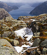
 Preikestolen in late November 2018, Lysefjord under a mist
 -
 View from the foot path


See also edit
References edit
- ^ "Preikestolen, Strand (Rogaland)" (in Norwegian). yr.no. Retrieved 2020-08-14.
- ^ a b Mikalsen, Knut-Erik (17 July 2012). "Kan Preikestolen falle ned?" (in Norwegian). Aftenposten. Archived from the original on 14 July 2012. Retrieved 23 July 2012.
- ^ "Slik ble sherpa-stien til Preikestolen". 7 June 2013.
- ^ Karlsen, Gard (May 2003). "Trip to Preikestolen (Pulpit Rock)". Retrieved 2008-08-18.
- ^ "Top Hikes: The Pulpit Rock (Preikestolen)". NextStopNorway.
- ^ "Bli med på tur til fantastiske Preikestolen!". fjordnorway.com.
- ^ "Rogaland - Norled". norled.no. Archived from the original on 2015-03-11. Retrieved 2013-11-24.
- ^ "Lysefjordsightseeing". Rødne Fjord Cruise.
- ^ "Referanser".
- ^ "Ruster Preikestolen opp for 3,5 millioner". 11 March 2019.
- ^ Knutsen, Håvard T.; Stenberg, Inger Johanne (9 October 2013). "– Vi har alltid fryktet at dette kunne skje" (in Norwegian). NRK. Retrieved 10 October 2013.
- ^ Kagda, Sakina; Cooke, Barbara; Nevins, Debbie (July 2016). Norway (Third ed.). New York, NY: Cavendish Square Publishing LLC. p. 11. ISBN 9781502618498. Retrieved June 20, 2020.
- ^ "Inngikk dødspakt". VG. 23 February 2000.
- ^ "Ville hoppe fra Prekestolen". dagbladet.no. 26 October 2004.
- ^ Aol travel. "Spanish tourist first to die at Norway's Pulpit Rock - AOL Travel UK". AOL Travel UK.
- ^ "el espanol que murio en preikestolen era un suicida". wordpress.com. Archived from the original on 2014-03-16.
- ^ "Preikestolen-dødsfall kan ha vært planlagt". fvn.no.
- ^ "Norway's Preikestolen closed to visitors after fatality". The Local - Norway's News in English. 22 July 2020.
- ^ "Områdebeskrivelse" (in Norwegian). Preikestolen nasjonalpark. Retrieved 23 July 2012.
- ^ "Foreningen NORDEN, Langeskov". Archived from the original on 6 January 2013. Retrieved 23 July 2012.
- ^ "Selger frisk luft fra Preikestolen på eBay". Stavanger Aftenblad. Retrieved 15 August 2016.
- ^ web desk, India Today (31 July 2018). "The climax of Mission Impossible : Fall out set in India, Kashmir". India Today. Retrieved 13 January 2020.
- ^ Archived at Ghostarchive and the Wayback Machine: "KO 2011 Making of Amali Thumali Song Video". YouTube.
External links edit
- Preikestolen – 360* Panoramic Pictures – Virtual Norge
- Preikestolen.no
- Preikestolen365.com
- Ryfylke.com
- Preikestolen Fjellstue