


Summary
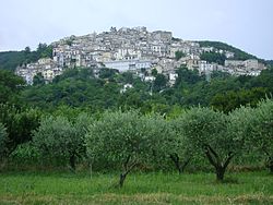
Pretoro (locally Pretèure) is a town of about 1,100 inhabitants situated in Majella National Park, in the province of Chieti, Abruzzo, southern Italy. It is located on a steep hillside on the eastern side of the Maiella mountains. Its proximity to Passo Lanciano-La Majelletta ski area, guarantees the availability of winter sports, while the town is also only 20 minutes by car from the Adriatic Sea. It is one of I Borghi più belli d'Italia ("The most beautiful villages of Italy").[3]
Pretoro | |
|---|---|
| Comune di Pretoro | |
 | |
Location of Pretoro .mw-parser-output .locmap .od{position:absolute}.mw-parser-output .locmap .id{position:absolute;line-height:0}.mw-parser-output .locmap .l0{font-size:0;position:absolute}.mw-parser-output .locmap .pv{line-height:110%;position:absolute;text-align:center}.mw-parser-output .locmap .pl{line-height:110%;position:absolute;top:-0.75em;text-align:right}.mw-parser-output .locmap .pr{line-height:110%;position:absolute;top:-0.75em;text-align:left}.mw-parser-output .locmap .pv>div{display:inline;padding:1px}.mw-parser-output .locmap .pl>div{display:inline;padding:1px;float:right}.mw-parser-output .locmap .pr>div{display:inline;padding:1px;float:left}html.skin-theme-clientpref-night .mw-parser-output .od,html.skin-theme-clientpref-night .mw-parser-output .od .pv>div,html.skin-theme-clientpref-night .mw-parser-output .od .pl>div,html.skin-theme-clientpref-night .mw-parser-output .od .pr>div{background:#fff;color:#000}html.skin-theme-clientpref-night .mw-parser-output .locmap{filter:grayscale(0.6)}@media(prefers-color-scheme:dark){html.skin-theme-clientpref-os .mw-parser-output .locmap{filter:grayscale(0.6)}html.skin-theme-clientpref-os .mw-parser-output .od,html.skin-theme-clientpref-os .mw-parser-output .od .pv>div,html.skin-theme-clientpref-os .mw-parser-output .od .pl>div,html.skin-theme-clientpref-os .mw-parser-output .od .pr>div{background:white;color:#000}}  Pretoro Location of Pretoro in Italy  Pretoro Pretoro (Abruzzo) | |
| Coordinates: 42°13′N 14°8′E / 42.217°N 14.133°E | |
| Country | Italy |
| Region | Abruzzo |
| Province | Chieti (CH) |
| Frazioni | Colle Pagnotto, Passo Lanciano, Ponte |
| Government | |
| • Mayor | Sabrina Simone |
| Area | |
| • Total | 26.13 km2 (10.09 sq mi) |
| Elevation | 560 m (1,840 ft) |
| Population (31 March 2018)[2] | |
| • Total | 948 |
| • Density | 36/km2 (94/sq mi) |
| Demonym | Pretoresi |
| Time zone | UTC+1 (CET) |
| • Summer (DST) | UTC+2 (CEST) |
| Postal code | 66010 |
| Dialing code | 0871 |
| Saint day | 6 May |
| Website | Official website |
History edit
The area in which Pretoro is located has been occupied since prehistoric times; remains from that period have been found here, as well as inscriptions in Latin from the Roman era. The first documented mention of the town is in a 12th-century record. Pretoro's name may derive from the word "preta", an earlier form of the word "pietra" or stone. The town stands on a rocky landscape that does not lend itself to farming. Because the town is surrounded by beech-forest, the people of Pretoro have specialized over the centuries in woodcarving.
Main sights edit
Pretoro is composed of a cluster of stone buildings which climb the steep mountainside; the oldest part of the town is at the highest point, while down below is a newer section.
The 13th century Sanctuary of the Madonna della Mazza is located a little above the town. This was a hermitage built by Benedictine and Cistercian monks from Santa Maria Arabona at Manoppello. A work of art is the 16th century sculpture of the Pietà preserved in the church of San Nicola.
Within the town's territory is a nature preserve, the Riserva Naturale Valle del Foro.
People edit
- Maria Pellegrini, operatic soprano[4]
References edit
- ^ "Superficie di Comuni Province e Regioni italiane al 9 ottobre 2011". Italian National Institute of Statistics. Retrieved 16 March 2019.
- ^ All demographics and other statistics from the Italian statistical institute (Istat)
- ^ "Abruzzo" (in Italian). Retrieved 1 August 2023.
- ^ Harvey Chusid (March 14, 2010). "Maria Pellegrini". The Canadian Encyclopedia.
External links edit
- Official website