
KNOWPIA
WELCOME TO KNOWPIA

Prissac 
Summary
Prissac (French pronunciation: [pʁisak]) is a commune in the Indre department in central France. Gaston Chérau (1872–1937), a writer and member of the Académie Goncourt is buried in Prissac.
Prissac | |
|---|---|
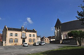 The 8 May Square in Prissac | |
Location of Prissac .mw-parser-output .locmap .od{position:absolute}.mw-parser-output .locmap .id{position:absolute;line-height:0}.mw-parser-output .locmap .l0{font-size:0;position:absolute}.mw-parser-output .locmap .pv{line-height:110%;position:absolute;text-align:center}.mw-parser-output .locmap .pl{line-height:110%;position:absolute;top:-0.75em;text-align:right}.mw-parser-output .locmap .pr{line-height:110%;position:absolute;top:-0.75em;text-align:left}.mw-parser-output .locmap .pv>div{display:inline;padding:1px}.mw-parser-output .locmap .pl>div{display:inline;padding:1px;float:right}.mw-parser-output .locmap .pr>div{display:inline;padding:1px;float:left}html.skin-theme-clientpref-night .mw-parser-output .od,html.skin-theme-clientpref-night .mw-parser-output .od .pv>div,html.skin-theme-clientpref-night .mw-parser-output .od .pl>div,html.skin-theme-clientpref-night .mw-parser-output .od .pr>div{background:#000;color:#fff}html.skin-theme-clientpref-night .mw-parser-output .locmap{filter:grayscale(0.6)}@media(prefers-color-scheme:dark){html.skin-theme-clientpref-os .mw-parser-output .locmap{filter:grayscale(0.6)}html.skin-theme-clientpref-os .mw-parser-output .od,html.skin-theme-clientpref-os .mw-parser-output .od .pv>div,html.skin-theme-clientpref-os .mw-parser-output .od .pl>div,html.skin-theme-clientpref-os .mw-parser-output .od .pr>div{background:#000;color:#fff}}  Prissac  Prissac | |
| Coordinates: 46°30′39″N 1°18′31″E / 46.5108°N 1.3086°E | |
| Country | France |
| Region | Centre-Val de Loire |
| Department | Indre |
| Arrondissement | Le Blanc |
| Canton | Saint-Gaultier |
| Government | |
| • Mayor (2020–2026) | Gilles Touzet[1] |
| Area 1 | 62.83 km2 (24.26 sq mi) |
| Population (2021)[2] | 579 |
| • Density | 9.2/km2 (24/sq mi) |
| Time zone | UTC+01:00 (CET) |
| • Summer (DST) | UTC+02:00 (CEST) |
| INSEE/Postal code | 36168 /36370 |
| Elevation | 105–199 m (344–653 ft) (avg. 165 m or 541 ft) |
| 1 French Land Register data, which excludes lakes, ponds, glaciers > 1 km2 (0.386 sq mi or 247 acres) and river estuaries. | |
Geography edit
The commune is located in the parc naturel régional de la Brenne.
The river Abloux flows west through the southern part of the commune, then flows into the Anglin, which forms all of its southwestern border.
Population edit
| Year | Pop. | ±% p.a. |
|---|---|---|
| 1968 | 966 | — |
| 1975 | 892 | −1.13% |
| 1982 | 853 | −0.64% |
| 1990 | 771 | −1.26% |
| 1999 | 738 | −0.48% |
| 2009 | 676 | −0.87% |
| 2014 | 656 | −0.60% |
| 2020 | 582 | −1.98% |
| Source: INSEE[3] | ||
See also edit
References edit
- ^ "Répertoire national des élus: les maires". data.gouv.fr, Plateforme ouverte des données publiques françaises (in French). 2 December 2020.
- ^ "Populations légales 2021". The National Institute of Statistics and Economic Studies. 28 December 2023.
- ^ Population en historique depuis 1968, INSEE
Wikimedia Commons has media related to Prissac.