
KNOWPIA
WELCOME TO KNOWPIA

Ptghni 
Summary
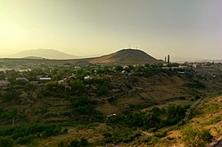
Ptghni (Armenian: Պտղնի), is a village located in the Kotayk Province of Armenia along the left bank of the Hrazdan River. It was founded in 1831 in the vicinity of an abandoned dwelling. The village has a school, kindergarten, house of culture, and a library. The local economy is dependent on agriculture and local inhabitants primarily grow grapes, melons, gourds, and breed cattle. Within the village are the remains of fortress walls and Ptghavank of the 6th to 7th-century.[1][2]
Ptghni Պտղնի | |
|---|---|
 Ptghni | |
 Ptghni Պտղնի | |
| Coordinates: 40°15′24″N 44°35′06″E / 40.25667°N 44.58500°E | |
| Country | Armenia |
| Marz (Province) | Kotayk |
| Founded | 1831 |
| Government | |
| • Mayor | Arakel Virabyan |
| Area | |
| • Total | 6.22 km2 (2.40 sq mi) |
| Elevation | 1,350 m (4,430 ft) |
| Population (2008) | |
| • Total | 1,337 |
| • Density | 210/km2 (560/sq mi) |
| Time zone | |
| • Summer (DST) | UTC+5 |
Gallery edit
-
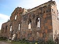 Ptghnavank, 6th-7th c.
 -
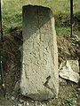 Khachkar monument beside the road leading to the village.


See also edit
References edit
- Ptghni at GEOnet Names Server
- World Gazeteer: Armenia[dead link] – World-Gazetteer.com
- Report of the results of the 2001 Armenian Census, Statistical Committee of Armenia
- Ptghnavank Monastery
- Ptghnavank2
- Ptghnavank3
- Ptghnavank4
- Ptghnavank5
External links edit
- Communities Association of Armenia: Ptghni
- Ptghnavank MonasteryPtghnavank2Ptghnavank3Ptghnavank4Ptghnavank5