


Summary
Pukete | |
|---|---|
 Pukete, Hamilton | |
| Coordinates: .mw-parser-output .geo-default,.mw-parser-output .geo-dms,.mw-parser-output .geo-dec{display:inline}.mw-parser-output .geo-nondefault,.mw-parser-output .geo-multi-punct,.mw-parser-output .geo-inline-hidden{display:none}.mw-parser-output .longitude,.mw-parser-output .latitude{white-space:nowrap}37°44′37.65″S 175°14′22.92″E / 37.7437917°S 175.2397000°E | |
| Country | New Zealand |
| City | Hamilton, New Zealand |
| Local authority | Hamilton City Council |
| Electoral ward | West Ward |
| Established | 1969 |
| Area | |
| • Land | 193 ha (477 acres) |
| Population (June 2023)[2] | |
| • Total | 4,960 |
| Te Kowhai | Horotiu | Flagstaff |
| Rotokauri |
|
Harrowfield |
| Te Rapa | St Andrews | Queenwood |
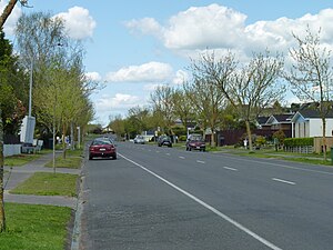
Pukete is a 1970s riverside suburb in northwestern Hamilton in New Zealand.[3]
The cobblestoned walk in the park has a grass dog exercise area. The riverside walkway, which includes many pedestrian bridges, can be used by walkers or cyclists, but the lower sections are subject to flooding in winter. A pedestrian bridge links Braithwaite Park to Flagstaff on the eastern side of the Waikato River. A 2015 River Plan proposed it become 'a flower garden bridge'.[4]
There is a small beach on the west side of the river at Braithwaite park often used in summer by water skiers and picnickers. To the north of the residential area is the Pukete Mountain Bike track, an Equestrian centre, and a two-lane launching ramp into the Waikato River, all on the Pukete Farm Park. A concreted riverside track, for bikes and pedestrians, runs north from Mountain View Lane starting by the southeast side of the Fonterra Te Rapa Milk powder factory.[citation needed]
The eastern part of Pukete and neighbouring St Andrews is built on an old river terrace. This rises to the flat alluvial fan that covers most of Hamilton. The land rises to one of Hamilton's many small hills at Ngaio Place giving views over most of Hamilton.[citation needed]
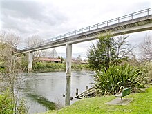
Four-laning of the Pukete Bridge was completed in Easter 2013, well ahead of schedule due to the long dry summer.[citation needed]
Demographics edit
Pukete covers 1.93 km2 (0.75 sq mi)[1] and had an estimated population of 4,960 as of June 2023,[2] with a population density of 2,570 people per km2.
| Year | Pop. | ±% p.a. |
|---|---|---|
| 2006 | 4,497 | — |
| 2013 | 4,296 | −0.65% |
| 2018 | 4,605 | +1.40% |
| Source: [5] | ||
Pukete had a population of 4,605 at the 2018 New Zealand census, an increase of 309 people (7.2%) since the 2013 census, and an increase of 108 people (2.4%) since the 2006 census. There were 1,539 households, comprising 2,298 males and 2,307 females, giving a sex ratio of 1.0 males per female, with 1,071 people (23.3%) aged under 15 years, 975 (21.2%) aged 15 to 29, 2,082 (45.2%) aged 30 to 64, and 477 (10.4%) aged 65 or older.
Ethnicities were 77.4% European/Pākehā, 19.6% Māori, 4.9% Pacific peoples, 10.7% Asian, and 2.3% other ethnicities. People may identify with more than one ethnicity.
The percentage of people born overseas was 20.2, compared with 27.1% nationally.
Although some people chose not to answer the census's question about religious affiliation, 54.7% had no religion, 32.9% were Christian, 0.9% had Māori religious beliefs, 2.2% were Hindu, 0.4% were Muslim, 0.7% were Buddhist and 1.9% had other religions.
Of those at least 15 years old, 753 (21.3%) people had a bachelor's or higher degree, and 549 (15.5%) people had no formal qualifications. 681 people (19.3%) earned over $70,000 compared to 17.2% nationally. The employment status of those at least 15 was that 2,043 (57.8%) people were employed full-time, 477 (13.5%) were part-time, and 159 (4.5%) were unemployed.[5]
Individual census areas edit
Pukete includes two census areas, East[6] and West.[7] The population is stable and they are wealthier and younger than the 37.4 years of the national average, as shown below -
| East | West | National median income | |||||||
|---|---|---|---|---|---|---|---|---|---|
| Year | Population | Average age | Households | Median income | Population | Average age | Households | Median income | |
| 1996 | 2,409 | 777 | 1,980 | 618[8] | |||||
| 2001 | 2,409 | 33.2 | 801 | $25,500 | 2,085 | 30.2 | 675 | $24,100 | $18,500 |
| 2006 | 2,397 | 33.3 | 810 | $31,800 | 2,103 | 29.8 | 675 | $29,900 | $24,100 |
| 2013 | 2,280 | 35.8 | 816 | $38,100 | 2,016 | 32.7 | 675 | $32,900 | $27,900[9] |
| 2018 | 2,361 | 35 | 825 | $40,600 | 2,244 | 32.2 | 717 | $36,900 | $31,800 |
In 2018 the main ethnic groups were -
| Area | European | Māori | Asian |
|---|---|---|---|
| East | 80.9% | 15.1% | 10.8% |
| West | 73.7% | 24.3% | 10.7% |
History edit
Pukete Pa is located in the north of the suburb on a cliff on the Waikato River bank, at the northern end of the riverside Braithwate Park. It is thought to have been built by Nga Iwi and later conquered by Ngati Koura[10] The name Pukete comes from a locally made bag used to soak hinau berries in streams to ferment and preserve them.[10] The area was confiscated in 1864, after the invasion of the Waikato.[11] A double ditch remains to the north of the Pa. Carved wooden items, found close to the pā, are in Waikato Museum. Habitation was sparse, as one early European traveller noted no other settlement for 15 mi (24 km) along the Waikato.[10]
Pukete parish existed from at least 1867,[12] but, until the 1900s, Horotiu was often referred to as Pukete. Horotiu railway station changed its name from Pukete on 23 June 1907,[13] when the proposed post office was referred to as Horotiu (Pukete),[14] and the name of Horotiu school changed from Pukete in 1911.
Pukete and neighbouring Te Rapa were important sites for the kauri gum trade of the late 19th/early 20th centuries, being some of the southern-most locations where gum could be found.[15]
In 2011 Hamilton Libraries compiled a list of street names, showing that most development occurred over about a decade from 1969, that many roads were named after trees and several developers were involved[16] Before long, Pukete School was opened in 1972 and a swimming pool in 1975. Rather slower to open were a library in 1999 and Te Manawa Hall in 2002.[17]
| Street name | Date | Named by | Source of name |
|---|---|---|---|
| Church Road | 1945-50 | Waipa County Council | after a Waipa County councillor of 1945 |
| Ashurst Avenue | 1969 | Taupo Totara Timber Company | tree theme |
| Sherwood Drive | 1969 | Taupo Totara Timber Company | tree theme |
| Totara Drive | 1969 | Taupo Totara Timber Company | tree theme |
| Challinor Street | 1969 | Builders Land Services | after R.C. Clough, chairman of the board |
| Clematis Avenue | 1969 | Builders Land Services | tree theme |
| Pukete Road | 1969 | Builders Land Services | parish name |
| Fuchsia Avenue | 1971 | Builders Land Services | tree theme |
| Houhere Place | 1971 | Builders Land Services | tree theme |
| Kohekohe Place | 1971 | Builders Land Services | tree theme |
| Pohutukawa Drive | 1971 | Builders Land Services | tree theme |
| Tanekaha Place | 1971 | Builders Land Services | tree theme |
| Titoki Place | 1973 | Builders Land Services | tree theme |
| Elmwood Crescent | 1973 | Taupo Totara Timber Company | tree theme |
| Oakfield Crescent | 1973 | Taupo Totara Timber Company | tree theme |
| Cullimore Street | 1974 | Peerless Homes Ltd | after Bert Cullimore, Housing Corporation |
| Frost Place | 1974 | Peerless Homes Ltd | land owner |
| Highland Drive | 1974 | Peerless Homes Ltd | |
| Manuka Street | 1974 | Builders Land Services | tree theme |
| Nikau Place | 1975 | Builders Land Services | tree theme |
| Norfolk Place | 1975 | Peerless Homes Ltd | tree theme |
| Ash Place | 1976 | Peerless Homes Ltd | tree theme |
| Cypress Crescent | 1976 | Peerless Homes Ltd | tree theme |
| Matipo Crescent | 1976 | Brian Perry Developments | tree theme |
| Ngaio Place | 1977 | Builders Land Services | tree theme |
| Cherrywood Street | 1977 | Taupo Totara Timber Company | tree theme |
| Chestnut Place | 1977 | Taupo Totara Timber Company | tree theme |
| Sycamore Place | 1977 | Taupo Totara Timber Company | tree theme |
| Willowfield Place | 1977 | Taupo Totara Timber Company | tree theme |
| O'Connell Court | 1977 | Housing Corporation | land owner |
| Horoeka Court | 1978 | Paramount Builders Ltd | tree theme |
| Kupe Place | 1999 | Grasshopper Developments | Taranaki gas field |
| Maui Street | 1999 | Grasshopper Developments | Taranaki gas field |
| McKee Street | 1999 | Grasshopper Developments | Taranaki gas field |
| Karewa Place | 2002 | Wairere Drive Properties Ltd | Karewa Island, Bay of Plenty |
Braithwaite Park edit
Braithwaite Park was owned by Waikato Hospital Board, who sold it to developers in 1990, the park being transferred to Hamilton City Council on 12 June 1990.[10] It has a jetty,[18] which is the terminus of a ferry to Hamilton.[19]
Education edit
Pukete School is a co-educational state primary school for Year 1 to 6 students with a roll of 343 as of February 2024.[20][21] The first Pukete School was established in 1879, and burned down in 1909.[22] The current school opened in 1973.[23]
Te Rapa School also serves the area.
See also edit
References edit
- ^ a b "ArcGIS Web Application". statsnz.maps.arcgis.com. Retrieved 14 October 2022.
- ^ a b "Population estimate tables - NZ.Stat". Statistics New Zealand. Retrieved 25 October 2023.
- ^ "Hamilton Map". Hamilton City Council. Archived from the original on 23 September 2010. Retrieved 18 September 2010.
- ^ "The River Plan - Hamilton City Council". www.hamilton.govt.nz. Retrieved 3 April 2020.
- ^ a b "Statistical area 1 dataset for 2018 Census". Statistics New Zealand. March 2020. Pukete West (175700) and Pukete East (176000).
- ^ "Pukete East". www.stats.govt.nz. Retrieved 3 April 2020.
- ^ "Pukete West". www.stats.govt.nz. Retrieved 3 April 2020.
- ^ "2006 Census of Population and Dwellings - Hamilton City". Stats NZ.
- ^ "2013 Census map – QuickStats about a place". archive.stats.govt.nz. Retrieved 12 March 2020.
- ^ a b c d "MAORI LANDMARKS ON RIVERSIDE RESERVES Management Plan" (PDF). Hamilton City Council. April 2003.
- ^ "Proclamation of Native Lands under the New Zealand Settlements Act. (Daily Southern Cross, 1865-06-21)". paperspast.natlib.govt.nz National Library of New Zealand. Retrieved 10 June 2017.
- ^ "The Daily Southern Cross. (1867-08-02)". paperspast.natlib.govt.nz National Library of New Zealand. Retrieved 13 June 2017.
- ^ Scoble, Juliet (2010). "Names & Opening & Closing Dates of Railway Stations in New Zealand 1863 to 2010" (PDF). Rail Heritage Trust of New Zealand.
- ^ "The Waikato Argus. TUESDAY, MAY 21, 1907". paperspast.natlib.govt.nz National Library of New Zealand. Retrieved 13 June 2017.
- ^ Hayward, Bruce W. (1989). Kauri Gum and the Gumdiggers. The Bush Press. p. 4. ISBN 0-908608-39-X.
- ^ "Results in topics for your search 'Pukete'". ketehamilton.peoplesnetworknz.info. Retrieved 4 April 2020.
- ^ "Our History". Pukete School. Retrieved 3 April 2020.
- ^ "Waikato River". Google Maps. March 2018. Retrieved 31 July 2021.
- ^ "Shuttle timetable" (PDF). Waikato River Explorer. 14 July 2021.
- ^ "New Zealand Schools Directory". New Zealand Ministry of Education. Retrieved 14 March 2024.
- ^ Education Counts: Pukete School
- ^ "1842 to 1970 Timeline". Pukete School. Retrieved 15 October 2020.
- ^ "1970 to 2020 Timeline". Pukete School. Retrieved 15 October 2020.