


Summary
Purnia District is one of the thirty-eight districts of the Indian state of Bihar. The city of Purnia is the administrative headquarters of this district. The city of Purnia has continued its tradition of hoisting the national flag at 12:07 am on every Independence Day since 1947. Purnia district is a part of Purnia Division. The district extends northwards from the Ganges river.
Purnia district | |
|---|---|
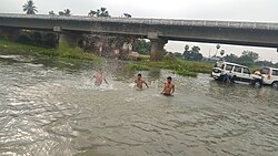 Saura river near Purnia | |
 Location of Purnia district in Bihar | |
| Country | |
| State | Bihar |
| Region | Mithila |
| Division | Purnia |
| Established | 14 February 1770 |
| Headquarters | Purnia |
| Tehsils |
|
| Government | |
| • District Magistrate | Mr. Kundan Kumar, IAS[1] |
| • Lok Sabha constituencies | Purnia, Katihar, Araria and Kishanganj |
| • Vidhan Sabha constituencies | Amour, Baisi, Kasba, Banmankhi, Rupauli, Dhamdaha, Purnia, |
| Area | |
| • Total | 3,229 km2 (1,247 sq mi) |
| Population (2011) | |
| • Total | 3,264,619 |
| • Density | 1,000/km2 (2,600/sq mi) |
| Demographics | |
| • Literacy | 72.09 per cent |
| • Sex ratio | 921 |
| • Major ethnolinguistic group | Maithils[2] |
| Language | |
| • Official | Hindi[3] |
| • Additional official | Urdu[3] |
| • Regional Languages | Maithili |
| Time zone | UTC+05:30 (IST) |
| Vehicle registration | BR-11 |
| Major highways | |
| Major Railway Lines | |
| Website | purnea |
History edit
Purnia is part of the Mithila region.[4] Mithila first gained prominence after it was settled by Indo-Aryan peoples who established the Mithila Kingdom (also called Kingdom of the Videhas).[5]
During the late Vedic period (c. 1100–500 BCE), Videha became one of the major political and cultural centers of Ancient India, along with Kuru and Pañcāla. The kings of the Videha Kingdom were called Janakas.[6] The Videha Kingdom was later incorporated into the Vajji confederacy, which had its capital in the city of Vaishali, which is also in Mithila.[7]
During the Mughal rule, Purnea was an outlying military province, and its revenue was mostly spent on protecting its borders against tribes from the north and east.[8] After the capture of Calcutta in 1757, Purnia's local governor raised a rebellion against Siraj ud-Daulah. In 1765, the district became a British possession, along with the rest of Bengal.[9] On February 14, 1770 the district of Purnia in modern history was formed by the East India Company.[10]
Purnia is known for its uniquely designed organization, Ramakrishna Mission, where the festival called Durga Puja is celebrated in October. Another attraction in the city of Purnia is the oldest temple of Mata Puran Devi which is 5 km away from the main city. It is theorized that Purnia received its name from this temple. Other theories also describe how Purnia received its name; which is, that in the past Purnia was named Purna– Aranya, which stands for "complete jungle."
Three districts were partitioned off from Purnia district: Katihar in 1976,[11] Araria and Kishanganj in 1990.[11]
Geography edit
Purnia district occupies 3,229 square kilometres (1,247 sq mi),[12] comparable to the Solomon Islands' Makira Island.[13] It is a depressed tract, consisting for the most part of a rich, loamy alluvial soil. It is traversed by several rivers flowing from the Himalayas, which afford great advantages of irrigation and water-carriage. Its major rivers are the Kosi, the Mahananda, the Suwara Kali, the Kari kosi, the Saura and the Koli. In the west, the soil is thickly covered with sand deposited by changes in the course of the Kosi. Among other rivers are the Mahananda and the Panar. Its major agricultural products are jute, maize and banana.
Divisions edit
Purnia district has four subdivisions: Purnea Sadar, Banmankhi, Baisi and Dhamdaha.
Blocks edit
They are further divided into fourteen blocks:
- Purnia East
- Kasba
- Jalalgarh
- Krityanand Nagar
- Srinagar
- Banmankhi
- Dhamdaha
- Barhara Kothi
- Bhawanipur
- Rupauli
- Baisi
- Baisa
- Amour
- Dagarua
These contain 246 panchayats with 1,450 villages.
Demographics edit
| Year | Pop. | ±% p.a. |
|---|---|---|
| 1901 | 478,222 | — |
| 1911 | 513,879 | +0.72% |
| 1921 | 548,740 | +0.66% |
| 1931 | 593,534 | +0.79% |
| 1941 | 646,133 | +0.85% |
| 1951 | 685,744 | +0.60% |
| 1961 | 938,810 | +3.19% |
| 1971 | 1,191,510 | +2.41% |
| 1981 | 1,518,223 | +2.45% |
| 1991 | 1,878,885 | +2.15% |
| 2001 | 2,543,942 | +3.08% |
| 2011 | 3,264,619 | +2.53% |
| source:[14] | ||
According to the 2011 census Purnia district has a population of 3,264,619,[15] roughly equal to the nation of Mauritania[16] or the US state of Iowa.[17] This gives it a ranking of 105th in India (out of a total of 640).[15] The district has a population density of 1,014 inhabitants per square kilometre (2,630/sq mi).[15] Its population growth rate over the decade 2001-2011 was 28.66%.[15] Purnia has a sex ratio of 930 females for every 1000 males,[15] and a literacy rate of 58.23%. 10.51% of the population lives in urban areas. Scheduled Castes and Scheduled Tribes make up 11.98% and 4.27% of the population respectively.[15]
Hindus are the majority community, but Muslims are majority in the eastern blocks.[18]
| Block | Hindu % | Muslim % | Other % |
|---|---|---|---|
| Banmankhi | 86.19 | 13.33 | 0.48 |
| Barhara | 90.37 | 9.11 | 0.52 |
| Bhawanipur | 75.48 | 24.07 | 0.45 |
| Rupauli | 89.20 | 10.57 | 0.23 |
| Dhamdaha | 84.32 | 14.55 | 1.13 |
| Krityanand Nagar | 67.07 | 32.03 | 0.9 |
| Purnia East | 68.52 | 30.26 | 1.22 |
| Kasba | 41.63 | 58.08 | 0.29 |
| Srinagar | 65.91 | 33.69 | 0.4 |
| Jalalgarh | 53.41 | 46.28 | 0.31 |
| Amour | 22.58 | 76.93 | 0.49 |
| Baisa | 27.76 | 71.94 | 0.3 |
| Baisi | 22.37 | 77.32 | 0.31 |
| Dagarua | 37.17 | 62.55 | 0.28 |
At the time of the 2011 Census of India, 33.68% of the population in the district spoke Hindi, 18.62% Urdu, 10.72% Maithili, 8.73% Surjapuri, 4.51% Bengali and 2.50% Santali as their first language. 18.53% spoke languages recorded as 'Others' under Hindi on the census.[19]
Politics edit
| District | No. | Constituency | Name | Party | Alliance | Remarks | ||
|---|---|---|---|---|---|---|---|---|
| Purnia | 56 | Amour | Akhtarul Iman | AIMIM | None | |||
| 57 | Baisi | Syed Ruknuddin Ahmad | RJD | MGB | Switched from AIMIM to RJD[20] | |||
| 58 | Kasba | Md Afaque Alam | INC | MGB | ||||
| 59 | Banmankhi | Krishna Kumar Rishi | BJP | NDA | ||||
| 60 | Rupauli | Bima Bharti | JD(U) | NDA | ||||
| 61 | Dhamdaha | Leshi Singh | JD(U) | NDA | ||||
| 62 | Purnia | Vijay Kumar Khemka | BJP | NDA | ||||
Economy edit
Recently, Oil and Natural Gas Corporation has started exploring Purnia basin for crude oil and Natural gas reserves. Estimations show that there might be about 465 million tonnes of reserves in the basin.[21][22]
Culture edit
Shrines edit
Some major Hindu temples of Purnea are Puran Devi temple; which is sometimes credited for the name of the city, the Kali Mandir of old Purnia city on the bank of Saura river, the Maata Asthan in Chunapur, Panchmukhi Temple in line bazaar, the Rani Sati Mandir in Kasba, Prahlad Stambh in Banmankhi, and Dhima Shiv Mandir in Dhima, Banmankhi. The city also has the Darghah of Hazrat Mustafa Jamalul Haque Bandagi, Chimni Bazar. An "Urs" in the form of Mela ( village fair) is organized on the 7th day after Eid-Ul-Azha and continues up to 3 days every year. The 'Dargah and Khanquah Alia Mustafia' is located 7 km away from the main city. It is famous for spirituality, communal harmony and Sufism. Its history extends for 400 years, when Hazrat Bandagi came from Jaunpur, Uttar Pradesh visiting several Khanqahs and Dargahs across India such as the Pandawa Sharif, the Bihar Sharif, etc. The Darghah is playing a major role to spread culture, education, kindness, secularism and spiritual spirits in Northeast Bihar since its establishment. Deorhi at Garbanili (Purnea) hosts the ruins of Kala Bhawan the ancient Darbar (Palace) of Raja Kalanand Singh, where his successor still lives.
The Jalalgadh Fort is a place of historical importance situated in Jalalgadh division.
River edit
Purnia District in the Indian state of Bihar is primarily drained by two major rivers:
- Kosi River : The Kosi River, often referred to as the "Sorrow of Bihar" due to its history of flooding, flows through Purnia District. It is an important river in the region and has a significant impact on the local landscape and livelihoods.
- Mahane River : The Mahane River is another prominent river in Purnia District. It is a tributary of the Kosi River and contributes to the overall drainage system of the area.
These rivers play a crucial role in the agricultural and ecological dynamics of Purnia District and are essential water sources for the local population.
References edit
- ^ "बिहार: पूर्णिया में SDM रहे कुंदन कुमार की Dm के रूप में वापसी, पीएम अवार्ड से सम्मानित, जानिए कारनामे".
- ^ "Election Results in Hindi (चुनाव परिणाम): West Bengal, Kerala, Assam, Tamil Nadu and Puducherry Election News in Hindi".
- ^ a b "52nd Report of the Commissioner for Linguistic Minorities in India" (PDF). nclm.nic.in. Ministry of Minority Affairs. Archived from the original (PDF) on 25 May 2017. Retrieved 22 January 2019.
- ^ Jha, Makhan (21 September 1997). Anthropology of Ancient Hindu Kingdoms: A Study in Civilizational Perspective. M.D. Publications Pvt. Ltd. ISBN 9788175330344 – via Google Books.
- ^ Michael Witzel (1989), Tracing the Vedic dialects in Dialectes dans les litteratures Indo-Aryennes ed. Caillat, Paris, pages 13, 17 116–124, 141–143
- ^ Witzel, M. (1989). "Tracing the Vedic dialects". In Caillat, C. (ed.). Dialectes dans les litteratures Indo-Aryennes. Paris: Fondation Hugot. pp. 141–143.
- ^ Hemchandra, R. (1972). Political History of Ancient India. Calcutta: University of Calcutta.
- ^ "Imperial Gazetteer2 of India, Volume 20, page 414 -- Imperial Gazetteer of India -- Digital South Asia Library". dsal.uchicago.edu.
- ^ "Imperial Gazetteer2 of India, Volume 20, page 415 -- Imperial Gazetteer of India -- Digital South Asia Library". dsal.uchicago.edu.
- ^ "Purnia district foundation day - Times of India". The Times of India. 15 February 2012.
- ^ a b Law, Gwillim (2011-09-25). "Districts of India". Statoids. Retrieved 2011-10-11.
- ^ Srivastava, Dayawanti et al. (ed.) (2010). "States and Union Territories: Bihar: Government". India 2010: A Reference Annual (54th ed.). New Delhi, India: Additional Director General, Publications Division, Ministry of Information and Broadcasting (India), Government of India. pp. 1118–1119. ISBN 978-81-230-1617-7.
{{cite book}}:|last1=has generic name (help) - ^ "Island Directory Tables: Islands by Land Area". United Nations Environment Program. 1998-02-18. Retrieved 2011-10-11.
Makira 3,190km2
- ^ "Table A-02 Decadal Variation in Population Since 1901: Bihar" (PDF). census.gov.in. Registrar General and Census Commissioner of India.
- ^ a b c d e f "District Census Handbook: Purnia" (PDF). Census of India. Registrar General and Census Commissioner of India. 2011.
- ^ US Directorate of Intelligence. "Country Comparison:Population". Archived from the original on June 13, 2007. Retrieved 2011-10-01.
Mauritania 3,681,634 July 2011 est.
- ^ "2010 Resident Population Data". U. S. Census Bureau. Retrieved 2011-09-30.
Iowa 3,046,355
- ^ a b "Table C-01 Population by Religion: Bihar". censusindia.gov.in. Registrar General and Census Commissioner of India. 2011.
- ^ a b "Table C-16 Population by Mother Tongue: Bihar". censusindia.gov.in. Registrar General and Census Commissioner of India. 2011.
- ^ "Bihar: Four of five AIMIM MLAs join RJD, making it single-largest party again with 80 seats". The Indian Express. 2022-06-30. Retrieved 2022-07-09.
- ^ Shankar, A. (2007-02-15). "ONGC eyes Bihar for oil exploration". Business Standard India. Retrieved 2021-01-10.
- ^ "ONGC walks away with all 7 oil, gas blocks on offer in latest bid round". The Financial Express. 2020-01-02. Retrieved 2021-01-10.
External links edit
- Official website
- Purnia Information Portal
List of Freedom Fighters of Purnea District
1. Shri Jibatsh Sharma 'Himanshu' native of Kajha Village, Block Krityanand Nagar, District Purnea
2.Fuleshwar Prasad Yadav,Native of Rikabganj Village Block Krityanand Nagar District Purnia