
KNOWPIA
WELCOME TO KNOWPIA

Pyramid Peak (Montana) 
Summary
Pyramid Peak (8,200–8,280 feet (2,499–2,524 m)) is in the Lewis Range, Glacier National Park in the U.S. state of Montana. Mokowanis Lake lies just northeast of the peak, and Atsina Lake is to the west.[3]
| Pyramid Peak | |
|---|---|
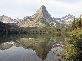 Pyramid Peak, as seen from Glenns Lake. | |
| Highest point | |
| Elevation | 8,200–8,280 ft (2,500–2,520 m)[1] |
| Prominence | 760 ft (230 m)[1] |
| Coordinates | 48°52′24″N 113°49′53″W / 48.87333°N 113.83139°W[2] |
| Geography | |
 Pyramid Peak Location in Montana  Pyramid Peak Location in the United States | |
| Location | Glacier County, Montana, United States |
| Parent range | Lewis Range |
| Topo map | USGS Ahern Pass, MT |
Climate edit
Based on the Köppen climate classification, it is located in an alpine subarctic climate zone with long, cold, snowy winters, and cool to warm summers.[4] Temperatures can drop below −10 °F with wind chill factors below −30 °F.

See also edit
References edit
- ^ a b "Pyramid Peak, Montana". Peakbagger.com. Retrieved December 27, 2018.
- ^ "Pyramid Peak". Geographic Names Information System. United States Geological Survey, United States Department of the Interior. Retrieved December 27, 2018.
- ^ Ahern Pass, MT (Map). TopoQwest (United States Geological Survey Maps). Retrieved December 27, 2018.
- ^ Peel, M. C.; Finlayson, B. L.; McMahon, T. A. (2007). "Updated world map of the Köppen−Geiger climate classification". Hydrol. Earth Syst. Sci. 11: 1633–1644. ISSN 1027-5606.