
KNOWPIA
WELCOME TO KNOWPIA

Radenac 
Summary
Radenac (French pronunciation: [ʁadnak]; Breton: Radeneg) is a commune in the Morbihan department in Brittany in north-western France.[3]
Radenac
Radeneg | |
|---|---|
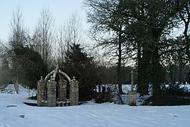 Fountain of St Fiacre | |
 Coat of arms | |
Location of Radenac .mw-parser-output .locmap .od{position:absolute}.mw-parser-output .locmap .id{position:absolute;line-height:0}.mw-parser-output .locmap .l0{font-size:0;position:absolute}.mw-parser-output .locmap .pv{line-height:110%;position:absolute;text-align:center}.mw-parser-output .locmap .pl{line-height:110%;position:absolute;top:-0.75em;text-align:right}.mw-parser-output .locmap .pr{line-height:110%;position:absolute;top:-0.75em;text-align:left}.mw-parser-output .locmap .pv>div{display:inline;padding:1px}.mw-parser-output .locmap .pl>div{display:inline;padding:1px;float:right}.mw-parser-output .locmap .pr>div{display:inline;padding:1px;float:left}html.skin-theme-clientpref-night .mw-parser-output .od,html.skin-theme-clientpref-night .mw-parser-output .od .pv>div,html.skin-theme-clientpref-night .mw-parser-output .od .pl>div,html.skin-theme-clientpref-night .mw-parser-output .od .pr>div{background:#000;color:#fff}html.skin-theme-clientpref-night .mw-parser-output .locmap{filter:grayscale(0.6)}@media(prefers-color-scheme:dark){html.skin-theme-clientpref-os .mw-parser-output .locmap{filter:grayscale(0.6)}html.skin-theme-clientpref-os .mw-parser-output .od,html.skin-theme-clientpref-os .mw-parser-output .od .pv>div,html.skin-theme-clientpref-os .mw-parser-output .od .pl>div,html.skin-theme-clientpref-os .mw-parser-output .od .pr>div{background:#000;color:#fff}}  Radenac  Radenac | |
| Coordinates: 47°57′49″N 2°42′41″W / 47.9636°N 2.7114°W | |
| Country | France |
| Region | Brittany |
| Department | Morbihan |
| Arrondissement | Pontivy |
| Canton | Grand-Champ |
| Intercommunality | Pontivy Communauté |
| Government | |
| • Mayor (2020–2026) | Bernard Le Breton[1] |
| Area 1 | 21.65 km2 (8.36 sq mi) |
| Population (2021)[2] | 1,067 |
| • Density | 49/km2 (130/sq mi) |
| Time zone | UTC+01:00 (CET) |
| • Summer (DST) | UTC+02:00 (CEST) |
| INSEE/Postal code | 56189 /56500 |
| Elevation | 72–131 m (236–430 ft) |
| 1 French Land Register data, which excludes lakes, ponds, glaciers > 1 km2 (0.386 sq mi or 247 acres) and river estuaries. | |
Geography edit
The river Ével has its source in the commune.
People edit
Cyclist Jean Robic, who won the Tour de France in 1947, spent his childhood in Radenac, where his father owned the local cycle shop. In honour of his great achievement, the commune renamed the street where his home was after him.
Population edit
Inhabitants of Radenac are called Radenacois.
| Year | Pop. | ±% p.a. |
|---|---|---|
| 1968 | 1,004 | — |
| 1975 | 903 | −1.50% |
| 1982 | 807 | −1.59% |
| 1990 | 832 | +0.38% |
| 1999 | 825 | −0.09% |
| 2007 | 962 | +1.94% |
| 2012 | 1,004 | +0.86% |
| 2017 | 1,059 | +1.07% |
| Source: INSEE[4] | ||
Twin towns edit
Radenac is twinned with a small village of Radnage in Buckinghamshire ![]() .
.
Monuments edit
- The fountain of St Armel (circa 1000)
- The fountain of St Fiacre (17th century)
- The chapelle St Fiacre (construction 1390 to 1514).
See also edit
References edit
- ^ "Maires du Morbihan" (PDF). Préfecture du Morbihan. 7 July 2020.
- ^ "Populations légales 2021". The National Institute of Statistics and Economic Studies. 28 December 2023.
- ^ INSEE commune file
- ^ Population en historique depuis 1968, INSEE
External links edit
Wikimedia Commons has media related to Radenac.
- Base Mérimée: Search for heritage in the commune, Ministère français de la Culture. (in French)
- Mayors of Morbihan Association (in French)