


Summary
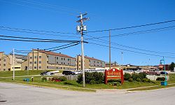
Radisson is a small unconstituted locality situated near the Robert-Bourassa hydroelectric power station on the La Grande River in the James Bay region of Quebec, Canada. Geographically, Radisson is located halfway between the southern and northernmost points in Quebec and is, besides Schefferville, the only non-native town north of the 53rd parallel in this province.[5]
Radisson | |
|---|---|
 | |
 Radisson | |
| Coordinates: 53°47′30″N 77°37′00″W / 53.79167°N 77.61667°W[1][2] | |
| Country | Canada |
| Province | Quebec |
| Region | Nord-du-Québec |
| TE | Jamésie |
| Municipality | Baie-James |
| Settled | 1975 |
| Government | |
| • Federal riding | Abitibi—Baie-James—Nunavik—Eeyou |
| • Prov. riding | Ungava |
| Area | |
| • Land | 4.81 km2 (1.86 sq mi) |
| Population (2016)[3] | |
| • Total | 468 |
| • Density | 97.3/km2 (252/sq mi) |
| • Change (2011–16) | |
| • Dwellings | 209 |
| [3][4] | |
| Time zone | UTC−05:00 (EST) |
| • Summer (DST) | UTC−04:00 (EDT) |
| Postal Code | J0Y 2X0 |
| Area code | 819 |
Despite its remoteness, Radisson has plenty of services for its residents and travellers: two fuel stations, hotel, motel, campground (summer only), a general store, restaurants, gift shops, a school and a hospital. It is also home to a huge Hydro-Québec employee facility, from where guided tours to the Robert-Bourassa power station start. It also houses employees of Air Inuit who are stationed at La Grande Rivière Airport.
The Cree village of Chisasibi is about 100 km (62 mi) to the west, near the mouth of the La Grande River. To the East is the Trans-Taiga Road (French: Route Transtaïga) that leads to the Caniapiscau Reservoir and the former construction camp of Caniapiscau (now used by a wilderness outfitter).
History edit
Radisson was founded in 1974 to accommodate workers for the James Bay hydroelectric project and named by the Société de développement de la Baie James after Pierre-Esprit Radisson, a 17th-century French explorer and founder of the Hudson's Bay Company.[2] During the peak construction period in 1977, its population reached about 2,500 and has fluctuated since that time. Currently it is a community of about 300 people. The main employer is Hydro-Québec and its main subsidiary, the Société de l'énergie de la Baie James. Many locals are also employed in the tourism/hospitality industry that caters especially to the outdoor sports, such as hunting, fishing, and camping.
Radisson, also referred to on some unofficial maps as "La Grande", is part of the Municipality of Baie-James which covers most of the territory of James Bay region, with the exception of the Cree villages as well as towns of Chapais, Chibougamau, Matagami and Lebel-sur-Quévillon, all of which are enclaves.

The town is accessible by road from Matagami, 620 km (390 mi) to the south. The road is known as the James Bay Road (French: Route de la Baie James) and was built during the construction of the James Bay Project in the mid-1970s. No services whatsoever are available along this road with the exception of a 24-hour service station, complete with cafeteria and lodging, at kilometre 381. The road is fully paved, well maintained and ploughed during the winter, making Radisson accessible year-round. It is also accessible via La Grande Rivière Airport.
Climate edit
| Climate data for La Grande Rivière (La Grande Rivière Airport) WMO ID: 71827; coordinates 53°38′N 77°42′W / 53.633°N 77.700°W; elevation: 195.1 m (640 ft); 1981–2010 normals | |||||||||||||
|---|---|---|---|---|---|---|---|---|---|---|---|---|---|
| Month | Jan | Feb | Mar | Apr | May | Jun | Jul | Aug | Sep | Oct | Nov | Dec | Year |
| Record high humidex | 1.8 | 4.8 | 11.1 | 21.8 | 33.9 | 37.5 | 44.3 | 35.5 | 31.6 | 28.3 | 11.7 | 7.6 | 44.3 |
| Record high °C (°F) | 1.4 (34.5) |
5.0 (41.0) |
11.3 (52.3) |
22.3 (72.1) |
32.6 (90.7) |
35.0 (95.0) |
37.3 (99.1) |
31.2 (88.2) |
27.1 (80.8) |
23.5 (74.3) |
12.3 (54.1) |
7.4 (45.3) |
37.3 (99.1) |
| Mean daily maximum °C (°F) | −18.5 (−1.3) |
−15.9 (3.4) |
−8.2 (17.2) |
0.6 (33.1) |
10.3 (50.5) |
17.3 (63.1) |
20.4 (68.7) |
18.6 (65.5) |
12.3 (54.1) |
4.8 (40.6) |
−3.1 (26.4) |
−12.0 (10.4) |
2.2 (36.0) |
| Daily mean °C (°F) | −23.2 (−9.8) |
−21.6 (−6.9) |
−14.5 (5.9) |
−5.0 (23.0) |
4.3 (39.7) |
10.8 (51.4) |
14.2 (57.6) |
13.1 (55.6) |
8.1 (46.6) |
1.7 (35.1) |
−6.1 (21.0) |
−16.0 (3.2) |
−2.9 (26.8) |
| Mean daily minimum °C (°F) | −28.0 (−18.4) |
−27.3 (−17.1) |
−20.7 (−5.3) |
−10.6 (12.9) |
−1.6 (29.1) |
4.2 (39.6) |
8.0 (46.4) |
7.6 (45.7) |
3.8 (38.8) |
−1.5 (29.3) |
−9.1 (15.6) |
−19.9 (−3.8) |
−7.9 (17.8) |
| Record low °C (°F) | −40.9 (−41.6) |
−44.6 (−48.3) |
−39.7 (−39.5) |
−31.4 (−24.5) |
−14.4 (6.1) |
−6.6 (20.1) |
−0.9 (30.4) |
−0.5 (31.1) |
−7.0 (19.4) |
−16.7 (1.9) |
−29.2 (−20.6) |
−40.3 (−40.5) |
−44.6 (−48.3) |
| Record low wind chill | −56 | −57 | −51 | −40 | −24 | −12 | −3 | −6 | −10 | −20 | −40 | −53 | −57 |
| Average precipitation mm (inches) | 30.9 (1.22) |
21.9 (0.86) |
29.4 (1.16) |
32.7 (1.29) |
39.0 (1.54) |
65.3 (2.57) |
78.5 (3.09) |
91.1 (3.59) |
110.6 (4.35) |
87.3 (3.44) |
67.9 (2.67) |
42.6 (1.68) |
697.2 (27.45) |
| Average rainfall mm (inches) | 0.1 (0.00) |
1.2 (0.05) |
3.4 (0.13) |
12.7 (0.50) |
27.9 (1.10) |
62.6 (2.46) |
78.5 (3.09) |
91.0 (3.58) |
106.9 (4.21) |
56.2 (2.21) |
11.6 (0.46) |
1.7 (0.07) |
453.8 (17.87) |
| Average snowfall cm (inches) | 33.1 (13.0) |
23.0 (9.1) |
28.6 (11.3) |
21.0 (8.3) |
11.9 (4.7) |
2.6 (1.0) |
0.0 (0.0) |
0.1 (0.0) |
4.0 (1.6) |
32.4 (12.8) |
60.3 (23.7) |
44.4 (17.5) |
261.3 (102.9) |
| Average precipitation days (≥ 0.2 mm) | 16.3 | 12.5 | 11.9 | 10.8 | 12.1 | 12.4 | 14.1 | 16.2 | 20.2 | 20.6 | 22.0 | 19.7 | 188.9 |
| Average rainy days (≥ 0.2 mm) | 0.33 | 0.67 | 1.10 | 4.00 | 8.00 | 11.60 | 14.00 | 16.30 | 19.50 | 12.70 | 4.10 | 0.84 | 92.90 |
| Average snowy days (≥ 0.2 cm) | 16.4 | 12.3 | 11.5 | 8.5 | 5.7 | 1.6 | 0.04 | 0.04 | 1.9 | 11.8 | 20.5 | 19.6 | 109.8 |
| Average afternoon relative humidity (%) (at 15:00) | 73.1 | 68.3 | 60.3 | 57.9 | 53.1 | 50.3 | 54.7 | 59.6 | 68.9 | 75.8 | 83.5 | 80.3 | 65.5 |
| Source: Environment and Climate Change Canada[6] | |||||||||||||
Demographics edit
In the 2021 Census of Population conducted by Statistics Canada, Radisson had a population of 203 living in 105 of its 235 total private dwellings, a change of -56.6% from its 2016 population of 468. With a land area of 4.83 km2 (1.86 sq mi), it had a population density of 42.0/km2 (108.9/sq mi) in 2021.[7]
References edit
- ^ "Radisson". Geographical Names Data Base. Natural Resources Canada.
- ^ a b "Radisson (village)" (in French). Commission de toponymie du Québec. Retrieved 2010-04-06.
- ^ a b c "Census Profile, 2016 Census". Statistics Canada. Government of Canada. January 23, 2017. Retrieved February 14, 2017.
- ^ "Radisson, Quebec (Code 240230) Census Profile". 2011 census. Government of Canada - Statistics Canada.
- ^ "Radisson".
- ^ "Canadian Climate Normals 1981-2010 Station Data". Environment and Climate Change Canada. Retrieved March 6, 2022.
- ^ "Population and dwelling counts: Canada and designated places". Statistics Canada. February 9, 2022. Retrieved Sep 2, 2022.
External links edit
 Media related to Radisson, Quebec at Wikimedia Commons
- Virtual tour of Radisson, photos (English)