
-
 Gurdwara Sahib Sikh Temple Ramgarh
 -
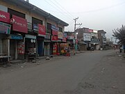 Ramgarh Main Market
 -
 Houses Architecture in Ramgarh Town

KNOWPIA
WELCOME TO KNOWPIA
Ramgarh, Jammu and Kashmir 
Summary
Ramgarh is a town and a notified area committee, near Samba town in Samba District in the Indian union territory of Jammu and Kashmir. Ramgarh is 18 km (11 mi) from Samba town, the district headquarter and 9 km (5.6 mi) from Vijaypur city National Highway.
Ramgarh | |
|---|---|
 Ramgarh Location in Samba district, Jammu and Kashmir, India  Ramgarh Ramgarh (India) | |
| Coordinates: 32°31′00″N 74°57′00″E / 32.5167°N 74.9500°E | |
| Country | |
| State | |
| District | Samba |
| Population (2001) | |
| • Total | 4,540 |
| Languages | |
| • Official | Hindi, Dogri |
| • Others | Kashmiri |
| Time zone | UTC+5:30 (IST) |
Demographics edit
As of 2001[update] India census,[1] Ramgarh had a population of 4,540. Males constitute 52% of the population and females 48%. Ramgarh has an average literacy rate of 67%, higher than the national average of 59.5%: male literacy is 75%, and female literacy is 59%. 14% of the population of Ramgarh is under 6 years of age.
Gallery edit


References edit
- ^ "Census of India 2001: Data from the 2001 Census, including cities, villages and towns (Provisional)". Census Commission of India. Archived from the original on 16 June 2004. Retrieved 1 November 2008.