
KNOWPIA
WELCOME TO KNOWPIA

Randall Island 
Summary
Randall Island (formerly Hensley Island)[1] is an island in the Sacramento River, in the Sacramento–San Joaquin River Delta.[2][3][4][5][6][7][8][9][10][11][12][13][14][15][16][17][18][19][20][21][22][23][24] It is part of Sacramento County, California, and managed by Reclamation District 755.[25] Its coordinates are 38°20′25″N 121°33′03″W / 38.34028°N 121.55083°W[1], and the United States Geological Survey measured its elevation as 0 ft (0 m) in 1981.[1] It is shown, labelled "Hensley Island", on an 1850 survey map of the San Francisco Bay area made by Cadwalader Ringgold[26] and an 1854 map of the area by Henry Lange.[27]
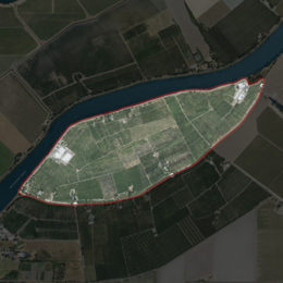 USGS aerial imagery of Randall Island | |
 Randall Island  Randall Island | |
| Geography | |
|---|---|
| Location | Northern California |
| Coordinates | 38°20′25″N 121°33′03″W / 38.34028°N 121.55083°W[1] |
| Adjacent to | Sacramento–San Joaquin River Delta |
| Highest elevation | 0 ft (0 m)[1] |
| Administration | |
United States | |
| State | |
| County | Sacramento |
References edit
- ^ a b c d e U.S. Geological Survey Geographic Names Information System: Randall Island
- ^ "Frightful Conditions On The Sacramento: Fighting The Water". The Evening Mail. Stockton, California. 1907-03-27. p. 4.
- ^ "On Monday, 19th day of May A.D. 1862". The Sacramento Bee. Sacramento, California. 1862-05-17. p. 4.
- ^ "Local News". The Sacramento Bee. Sacramento, California. 1865-12-25. p. 3.
- ^ "Condition of the State". The Sacramento Bee. Sacramento, California. 1878-05-06. p. 2.
- ^ "Randall's Island". The Record-Union. Sacramento, California. 1881-12-08. p. 1.
- ^ "Down the River". The Record-Union. Sacramento, California. 1893-11-20. p. 5.
- ^ "To Dispose Of Sewage: Trustees Will Negotiate for a Large Pump". The Record-Union. Sacramento, California. 1896-02-01. p. 4.
- ^ "Propose to Raise A Large Sum". The Sacramento Bee. Sacramento, California. 1904-06-10. p. 9.
- ^ "Storm Danger Is Over: Made Noble Fight. Many Desperate Struggles". The Sacramento Bee. Sacramento, California. 1907-03-26. p. 8.
- ^ "Finishes Up Big Contract". The Sacramento Bee. Sacramento, California. 1908-03-20. p. 14.
- ^ "River Record". The Sacramento Bee. Sacramento, California. 1909-01-22. p. 1.
- ^ "Farmers' Paradise". The Sacramento Star. Sacramento, California. 1911-07-24. p. 8.
- ^ "Peter B. Green". The Sacramento Star. Sacramento, California. 1913-01-20. p. 3.
- ^ "Randall Island First To Have New Highway". The Sacramento Star. Sacramento, California. 1916-11-23. p. 7.
- ^ "Commission Soon To Be Dissolved". The Sacramento Star. Sacramento, California. 1921-01-26. p. 9.
- ^ "County Commission Files Final Report". The Sacramento Bee. Sacramento, California. 1923-01-10. p. 18.
- ^ "To Determine Tax". The Sacramento Bee. Sacramento, California. 1926-10-26. p. 5.
- ^ "Land Of Great Fertility Is Tapped By New Route". The Sacramento Bee. Sacramento, California. 1925-12-29. p. 20.
- ^ "Levee Project Bidders Can Get Drawings Tuesday". The Sacramento Bee. Sacramento, California. 1954-04-17. p. 28.
- ^ "William H. Dean". The Sacramento Bee. Sacramento, California. 1956-05-02. p. 34.
- ^ "State Says Districts Lag In Maintaining River Levees". The Sacramento Bee. Sacramento, California. 1960-03-16. p. 28.
- ^ "Judge Grants Divorce To Delta Grower's Spouse". The Sacramento Bee. Sacramento, California. 1962-04-17. p. 15.
- ^ "Delta levees get FEMA scrutiny". The Sacramento Bee. Sacramento, California. 2008-10-30. p. B3.
- ^ "Sacramento County, California Reclamation Districts" (PDF). Sacramento Local Agency Formation Commission. August 2009. Retrieved 24 February 2021.
- ^ Ringgold, Cadwalader; Stuart, Fred D.; Everett, Chas.; Harrison (1850). "General Chart embracing Surveys of the Farallones Entrance to the Bay of San Francisco, Bays of San Francisco and San Pablo, Straits of Carquines and Suisun Bay, and the Sacramento and San Joaquin Rivers, to the Cities of Sacramento and San Joaquin, California". David Rumsey Map Collection. San Francisco Common Council. Archived from the original on 7 July 2017. Retrieved 25 February 2021.
- ^ Lange, Henry (1854). "Bai San Francisco und Vereinigung des Sacramento mit dem San Joaquin". David Rumsey Map Collection. George Westermann. Archived from the original on 10 March 2016. Retrieved 25 February 2021.