
KNOWPIA
WELCOME TO KNOWPIA

Rangkasbitung 
Summary
Rangkasbitung (Sundanese: ᮛᮀᮊᮞ᮪ᮘᮤᮒᮥᮀ) (colloquially called Rangkas) is a town that is the administrative centre of Lebak Regency, in Banten Province of Java, Indonesia. It had a population of 134,945 at the 2020 Census, while the official estimate as of mid-2021 was 137,041.[2]
Rangkasbitung
(Rangkasbitung Town) (Kecamatan Rangkasbitung) | |
|---|---|
| Other transcription(s) | |
| • Sundanese | ᮛᮀᮊᮞ᮪ᮘᮤᮒᮥᮀ |
| • Jawi | راڠكاسبيتوڠ |
 Rangkasbitung Location of Rangkasbitung in Indonesia | |
| Coordinates: 6°7′12″S 106°9′1″E / 6.12000°S 106.15028°E | |
| Country | |
| Province | |
| Regency | Lebak Regency |
| Government | |
| • Camat | Agus Sudrajat, S.Sos., M.Si. |
| Area | |
| • Total | 73.10 km2 (28.22 sq mi) |
| Population (mid 2021 estimate) | |
| • Total | 137,041 |
| • Density | 1,900/km2 (4,900/sq mi) |
| [1] | |
| Time zone | UTC+7 (WIB) |
| Area code | +62 252 |
| Website | web |
It is the site of the Multatuli Museum, a history museum that opened in 2018.
Climate edit
Rangkasbitung has a tropical rainforest climate (Af) with heavy rainfall year-round.
| Climate data for Rangkasbitung | |||||||||||||
|---|---|---|---|---|---|---|---|---|---|---|---|---|---|
| Month | Jan | Feb | Mar | Apr | May | Jun | Jul | Aug | Sep | Oct | Nov | Dec | Year |
| Mean daily maximum °C (°F) | 30.7 (87.3) |
31.1 (88.0) |
31.6 (88.9) |
32.2 (90.0) |
32.5 (90.5) |
32.4 (90.3) |
32.5 (90.5) |
32.6 (90.7) |
33.0 (91.4) |
33.1 (91.6) |
32.6 (90.7) |
31.9 (89.4) |
32.2 (89.9) |
| Daily mean °C (°F) | 26.7 (80.1) |
27.0 (80.6) |
27.2 (81.0) |
27.5 (81.5) |
27.7 (81.9) |
27.3 (81.1) |
27.1 (80.8) |
27.0 (80.6) |
27.5 (81.5) |
27.8 (82.0) |
27.7 (81.9) |
27.4 (81.3) |
27.3 (81.2) |
| Mean daily minimum °C (°F) | 22.8 (73.0) |
22.9 (73.2) |
22.8 (73.0) |
22.9 (73.2) |
23.0 (73.4) |
22.3 (72.1) |
21.8 (71.2) |
21.5 (70.7) |
22.0 (71.6) |
22.5 (72.5) |
22.9 (73.2) |
23.0 (73.4) |
22.5 (72.5) |
| Average rainfall mm (inches) | 321 (12.6) |
245 (9.6) |
242 (9.5) |
219 (8.6) |
184 (7.2) |
113 (4.4) |
136 (5.4) |
144 (5.7) |
144 (5.7) |
182 (7.2) |
190 (7.5) |
219 (8.6) |
2,339 (92) |
| Source: Climate-Data.org[3] | |||||||||||||
6°22′S 106°15′E / 6.367°S 106.250°E
Transportation edit
The town lies on the road connecting Jakarta, Serpong and Pandeglang. It is also connected with western railway line of Java, connecting Jakarta with Serang until Merak. The town is served by Jakarta Metrorail.
Notable residents edit
- Eduard Douwes Dekker or Multatuli, the author of Max Havelaar, once lived and worked in the town. His experience and observation during his time here triggered him to write the famous romance.
- Eugenia van Beers, the mother of American rock musicians Eddie van Halen and Alex van Halen was born in this town.[4]
-
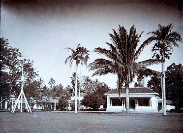 House of assistant-resident of Lebak in Rangkasbitung, where Eduard Douwes Dekker once lived.
 -
 The Ciberang and Ciujung rivers coming together at Rangkasbitung

