
KNOWPIA
WELCOME TO KNOWPIA

Rebets 
Summary
Rebets is a commune in the Seine-Maritime department in the Normandy region in northern France.
Rebets | |
|---|---|
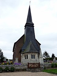 The church in Rebets | |
Location of Rebets .mw-parser-output .locmap .od{position:absolute}.mw-parser-output .locmap .id{position:absolute;line-height:0}.mw-parser-output .locmap .l0{font-size:0;position:absolute}.mw-parser-output .locmap .pv{line-height:110%;position:absolute;text-align:center}.mw-parser-output .locmap .pl{line-height:110%;position:absolute;top:-0.75em;text-align:right}.mw-parser-output .locmap .pr{line-height:110%;position:absolute;top:-0.75em;text-align:left}.mw-parser-output .locmap .pv>div{display:inline;padding:1px}.mw-parser-output .locmap .pl>div{display:inline;padding:1px;float:right}.mw-parser-output .locmap .pr>div{display:inline;padding:1px;float:left}html.skin-theme-clientpref-night .mw-parser-output .od,html.skin-theme-clientpref-night .mw-parser-output .od .pv>div,html.skin-theme-clientpref-night .mw-parser-output .od .pl>div,html.skin-theme-clientpref-night .mw-parser-output .od .pr>div{background:#000;color:#fff}html.skin-theme-clientpref-night .mw-parser-output .locmap{filter:grayscale(0.6)}@media(prefers-color-scheme:dark){html.skin-theme-clientpref-os .mw-parser-output .locmap{filter:grayscale(0.6)}html.skin-theme-clientpref-os .mw-parser-output .od,html.skin-theme-clientpref-os .mw-parser-output .od .pv>div,html.skin-theme-clientpref-os .mw-parser-output .od .pl>div,html.skin-theme-clientpref-os .mw-parser-output .od .pr>div{background:#000;color:#fff}}  Rebets  Rebets | |
| Coordinates: 49°30′42″N 1°23′26″E / 49.5117°N 1.3906°E | |
| Country | France |
| Region | Normandy |
| Department | Seine-Maritime |
| Arrondissement | Rouen |
| Canton | Le Mesnil-Esnard |
| Government | |
| • Mayor (2020–2026) | Bernard Corbillon[1] |
| Area 1 | 3.67 km2 (1.42 sq mi) |
| Population (2021)[2] | 148 |
| • Density | 40/km2 (100/sq mi) |
| Time zone | UTC+01:00 (CET) |
| • Summer (DST) | UTC+02:00 (CEST) |
| INSEE/Postal code | 76521 /76750 |
| Elevation | 82–176 m (269–577 ft) (avg. 93 m or 305 ft) |
| 1 French Land Register data, which excludes lakes, ponds, glaciers > 1 km2 (0.386 sq mi or 247 acres) and river estuaries. | |
Geography edit
A small farming village situated in the Pays de Bray, some 15 miles (24 km) northeast of Rouen at the junction of the D47 and the D86 roads. The small Héronchelles river, a tributary of the Andelle, flows through the commune.
Population edit
| Year | Pop. | ±% p.a. |
|---|---|---|
| 1968 | 91 | — |
| 1975 | 89 | −0.32% |
| 1982 | 101 | +1.82% |
| 1990 | 108 | +0.84% |
| 1999 | 110 | +0.20% |
| 2007 | 137 | +2.78% |
| 2012 | 142 | +0.72% |
| 2017 | 147 | +0.69% |
| Source: INSEE[3] | ||
Places of interest edit
See also edit
References edit
- ^ "Répertoire national des élus: les maires". data.gouv.fr, Plateforme ouverte des données publiques françaises (in French). 2 December 2020.
- ^ "Populations légales 2021". The National Institute of Statistics and Economic Studies. 28 December 2023.
- ^ Population en historique depuis 1968, INSEE
Wikimedia Commons has media related to Rebets.