


Summary
Red Mountain Pass elevation 11,018 ft (3,358 m) is a mountain pass in the San Juan Mountains of western Colorado in the United States.
| Red Mountain Pass | |
|---|---|
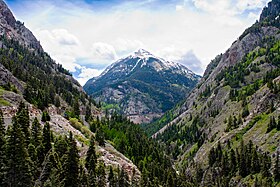 Lower gorge, Red Mountain Pass; view from HWY 550 near Ouray | |
| Elevation | 11,018 ft (3,358 m)[1] |
| Traversed by | |
| Location | Ouray / San Juan counties, Colorado, U.S. |
| Range | San Juan Mountains |
| Coordinates | 37°53′56″N 107°42′43″W / 37.89889°N 107.71194°W |

The pass straddles a divide that separates Ouray and San Juan counties. The pass is named for the nearby Red Mountain on the northeast side of the pass. The name is derived from the iron oxide laden rock that forms their slopes.
The pass separates the Uncompahgre and Las Animas River watersheds, and also serves as a dividing point between the Uncompahgre and San Juan National Forests. The pass is traversed by the Million Dollar Highway, U.S. Highway 550 between Ouray and Silverton, which is part of the San Juan Skyway Scenic Byway.
The pass is known for being treacherous in the wintertime due to the steep 8% grade and switchbacks on the north side facing Ouray, though the entire road is paved. Avalanches are frequent, and can block the highway for some time. The lower part of the pass towards Ouray is blasted into near-vertical cliffs of quartzite hundreds of feet above Red Mountain Creek and the Uncompahgre River. This section of road is winding, narrow and has no shoulder.
There are an average of seven deaths per year.[2]
Mining district edit
The Red Mountain Mining District lies from the divide northward to Ironton Park, halfway down towards Ouray. It was the site of a historic silver boom from 1882 until 1893, including the Yankee Girl and National Belle. Headframes of the old workings are still visible from the highway, as are the remains of the three largest communities: Red Mountain Town, Ironton, and Guston.[3][4] The sprawling Idarado Mine (Treasury Tunnel) continued digging until the 1970s, and reclamation of tailings is ongoing.
Climate edit
At an elevation of 11200 ft (3414m), Red Mountain Pass has a subalpine climate (Köppen Dfc), bordering on an Alpine climate (Köppen ET).
| Climate data for Red Mountain Pass, Colorado, 1991–2020 normals, 1982-2020 extremes: 11200ft (3414m) | |||||||||||||
|---|---|---|---|---|---|---|---|---|---|---|---|---|---|
| Month | Jan | Feb | Mar | Apr | May | Jun | Jul | Aug | Sep | Oct | Nov | Dec | Year |
| Record high °F (°C) | 57 (14) |
56 (13) |
72 (22) |
67 (19) |
76 (24) |
76 (24) |
78 (26) |
76 (24) |
73 (23) |
67 (19) |
63 (17) |
51 (11) |
78 (26) |
| Mean maximum °F (°C) | 47.9 (8.8) |
47.7 (8.7) |
53.4 (11.9) |
57.1 (13.9) |
63.3 (17.4) |
70.4 (21.3) |
72.8 (22.7) |
70.2 (21.2) |
67.0 (19.4) |
61.1 (16.2) |
54.0 (12.2) |
47.1 (8.4) |
73.6 (23.1) |
| Mean daily maximum °F (°C) | 32.1 (0.1) |
33.5 (0.8) |
40.0 (4.4) |
44.4 (6.9) |
52.1 (11.2) |
61.4 (16.3) |
65.4 (18.6) |
62.9 (17.2) |
57.3 (14.1) |
48.3 (9.1) |
38.8 (3.8) |
31.4 (−0.3) |
47.3 (8.5) |
| Daily mean °F (°C) | 19.8 (−6.8) |
20.6 (−6.3) |
26.2 (−3.2) |
31.4 (−0.3) |
39.7 (4.3) |
48.5 (9.2) |
53.1 (11.7) |
51.3 (10.7) |
45.7 (7.6) |
36.7 (2.6) |
26.8 (−2.9) |
19.6 (−6.9) |
34.9 (1.6) |
| Mean daily minimum °F (°C) | 7.4 (−13.7) |
7.6 (−13.6) |
12.5 (−10.8) |
18.3 (−7.6) |
27.2 (−2.7) |
35.6 (2.0) |
40.8 (4.9) |
39.7 (4.3) |
34.0 (1.1) |
25.0 (−3.9) |
14.7 (−9.6) |
7.8 (−13.4) |
22.5 (−5.2) |
| Mean minimum °F (°C) | −9.5 (−23.1) |
−8.2 (−22.3) |
−3.6 (−19.8) |
3.4 (−15.9) |
14.0 (−10.0) |
26.5 (−3.1) |
35.5 (1.9) |
34.4 (1.3) |
23.4 (−4.8) |
8.1 (−13.3) |
−4.4 (−20.2) |
−10.9 (−23.8) |
−13.8 (−25.4) |
| Record low °F (°C) | −33 (−36) |
−35 (−37) |
−25 (−32) |
−18 (−28) |
−10 (−23) |
2 (−17) |
28 (−2) |
26 (−3) |
0 (−18) |
−15 (−26) |
−22 (−30) |
−26 (−32) |
−35 (−37) |
| Average precipitation inches (mm) | 4.41 (112) |
4.30 (109) |
4.36 (111) |
4.29 (109) |
2.71 (69) |
1.09 (28) |
2.71 (69) |
3.05 (77) |
2.86 (73) |
3.36 (85) |
4.09 (104) |
4.08 (104) |
41.31 (1,050) |
| Average extreme snow depth inches (cm) | 61.2 (155) |
71.8 (182) |
79.6 (202) |
82.0 (208) |
60.0 (152) |
19.9 (51) |
1.5 (3.8) |
0.5 (1.3) |
1.8 (4.6) |
10.4 (26) |
27.7 (70) |
43.5 (110) |
88.8 (226) |
| Average precipitation days (≥ 0.01 in) | 15.2 | 15.3 | 15.3 | 14.8 | 10.2 | 4.8 | 10.7 | 13.1 | 10.0 | 10.7 | 13.7 | 15.3 | 149.1 |
| Source 1: XMACIS2[5] | |||||||||||||
| Source 2: NOAA (precip/precip days)[6] | |||||||||||||

References edit
- ^ "Red Mountain Pass". Geographic Names Information System. United States Geological Survey, United States Department of the Interior. Retrieved 2011-02-05.
- ^ Duran, Bailey (2023-02-28). "Million Dollar Highway named to list of most dangerous roads in the U.S." The Durango Herald. Retrieved 2024-04-15.
- ^ "Guston, Colorado". Western Mining History. Retrieved 9 March 2021.
- ^ Smith, P. David, (2004) "Mountains of Silver; Life in Colorado's Red Mountain Mining District": Western Reflections Publishing Co.
- ^ "xmACIS2". National Oceanic and Atmospheric Administration. Retrieved January 3, 2024.
- ^ "Red Mountain Pass, Colorado 1991-2020 Monthly Normals". Retrieved January 3, 2024.