
KNOWPIA
WELCOME TO KNOWPIA

Restoule River 
Summary
The Restoule River is a river in Parry Sound District in Central Ontario, Canada.[1] It rises at Commanda Lake in geographic Patterson Township[2] at the community of Restoule. It then flows north into Restoule Lake then north into Stormy Lake at Restoule Provincial Park, at the end of Ontario Highway 534. It then heads west into geographic Hardy Township[3] to its mouth at the French River.
| Restoule River | |
|---|---|
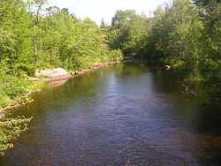 Restoule River looking north from Hawthorne Drive in the community of Restoule | |
 Location of the mouth of the Restoule River in Ontario | |
| Location | |
| Country | Canada |
| Province | Ontario |
| Region | Central Ontario |
| District | Parry Sound |
| Physical characteristics | |
| Source | Commanda Lake |
| • location | Restoule, Patterson Township |
| • coordinates | 46°01′36″N 79°43′12″W / 46.02667°N 79.72000°W |
| • elevation | 222 m (728 ft) |
| Mouth | French River |
• location | Hardy Township |
• coordinates | 46°06′29″N 80°01′03″W / 46.10806°N 80.01750°W |
• elevation | 187 m (614 ft) |
| Length | 40 km (25 mi) |
| Basin features | |
| River system | Lake Huron drainage basin |
The total length of the river is about 40 kilometres (20 mi). From Lennon Lake in Hardy Township to the mouth, the river forms a boundary of the Dokis 9 First Nations reserve.[3]
Tributaries edit
- Portage Creek (left)
- Burnt Lake Creek (right)
See also edit
References edit
- ^ "Restoule River". Geographical Names Data Base. Natural Resources Canada. Retrieved 2013-06-11.
- ^ "Patterson" (PDF). Geology Ontario - Historic Claim Maps. Ontario Ministry of Northern Development, Mines and Forestry. Retrieved 2013-06-11.[permanent dead link]
- ^ a b "Hardy" (PDF). Geology Ontario - Historic Claim Maps. Ontario Ministry of Northern Development, Mines and Forestry. Archived from the original (PDF) on 2016-03-04. Retrieved 2013-06-11.
Sources edit
- Map 8 (PDF) (Map). 1 : 700,000. Official road map of Ontario. Ministry of Transportation of Ontario. 2010-01-01. Retrieved 2013-06-11.
- Restructured municipalities - Ontario map #4 (Map). Restructuring Maps of Ontario. Ontario Ministry of Municipal Affairs and Housing. 2006. Retrieved 2013-06-11.