


Summary
Reynolds Mountain (9,125 feet (2,781 m)) is located in the Lewis Range, Glacier National Park in the U.S. state of Montana.[3] Reynolds Mountain is situated along the Continental Divide and is easily seen from Logan Pass by looking due south from the pass. Hidden Lake is located below Reynolds Mountain to the west. Reynolds is a class 2(3) climb via the southwestern talus slope route that allows many people to easily climb the peak. The mountain was named for Charles E. Reynolds, a writer for Forest and Stream magazine, and assistant to the magazine's editor, George Bird Grinnell, who named many of the features in Glacier National Park.[4] The mountain's name was officially adopted in 1910 by the U.S. Board on Geographic Names.[2]
| Reynolds Mountain | |
|---|---|
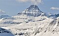
 Reynolds Mountain as seen from Logan Pass | |
| Highest point | |
| Elevation | 9,130 ft (2,780 m)[1] |
| Prominence | 1,285 ft (392 m)[1] |
| Coordinates | 48°40′19″N 113°43′24″W / 48.67194°N 113.72333°W[2] |
| Geography | |
 Reynolds Mountain Location in Montana  Reynolds Mountain Location in the United States | |
| Location | Flathead County, Montana, Glacier County, Montana, U.S. |
| Parent range | Lewis Range |
| Topo map | USGS Logan Pass, MT |
Geology edit
Like other mountains in Glacier National Park, Reynolds Mountain is composed of sedimentary rock laid down during the Precambrian to Jurassic periods. Formed in shallow seas, this sedimentary rock was initially uplifted beginning 170 million years ago when the Lewis Overthrust fault pushed an enormous slab of precambrian rocks 3 mi (4.8 km) thick, 50 miles (80 km) wide and 160 miles (260 km) long over younger rock of the cretaceous period.[5]
Gallery edit
-
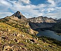 Reynolds Mountain (left) and Dragons Tail (right) above Hidden Lake
 -
 Reynolds Mountain is a classic horn, seen here from Bearhat Mountain
 -
 North face
 -
 Reynolds Mountain by Ansel Adams in 1942


See also edit
References edit
- ^ a b "Reynolds Mountain, Montana". Peakbagger.com. Retrieved December 27, 2018.
- ^ a b "Reynolds Mountain". Geographic Names Information System. United States Geological Survey, United States Department of the Interior. Retrieved December 27, 2018.
- ^ Logan Pass, MT (Map). TopoQwest (United States Geological Survey Maps). Retrieved December 27, 2018.
- ^ Erin Turner, "It Happened in the Old West", 2017, page 105.
- ^ Gadd, Ben (2008). "Geology of the Rocky Mountains and Columbias".
{{cite journal}}: Cite journal requires|journal=(help)
External links edit
- Reynolds Mountain: Weather