


Summary
The River Dane is a tributary of the River Weaver that originates in the Peak District area of England. The name of the river (earlier Daven) is probably from the Old Welsh dafn, meaning a "drop or trickle", implying a slow-moving river.[1]
| River Dane | |
|---|---|
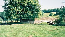
 The Dane at Three Shire Heads | |
| Location | |
| Country | England |
| Counties | Staffordshire, Cheshire, Derbyshire |
| Physical characteristics | |
| Source | |
| • location | Axe Edge Moor |
| Mouth | |
• location | Confluence with River Weaver |
| Basin features | |
| Tributaries | |
| • left | River Croco, River Wheelock |
Course edit
It forms the border between first Cheshire and Derbyshire on the west and east, and then between Cheshire and Staffordshire where it then flows north-west through Cheshire before meeting the Weaver in Northwich.
The river rises close to the source of the River Goyt just to the south west of Buxton, at Dane Head on Axe Edge Moor. Flowing southwest, it forms county borders for around 10 miles (16 km) before flowing west through Congleton and past Holmes Chapel. The point on the river where the three counties meet, at Panniers' Pool Bridge, is called Three Shire Heads (sometimes Three Shires Head).[2] Passing just north of Middlewich, it merges first with the River Croco near the site of the old Roman fort in Harbutt's Field, and then with the River Wheelock near the aqueduct carrying the Trent and Mersey Canal, and runs the remaining 5 miles (8 km) north to Northwich where it flows into the River Weaver.
The River Dane is the longest, cleanest and thought to be the fastest flowing river through Cheshire. The route of the Dane is followed as closely as possible by the Dane Valley Way, a 48-mile (77 km) walking route from Buxton to Northwich.[3]
Although the main river is part of the Mersey catchment and flows into the Irish Sea, a portion of the water can be diverted via canal feeders into Rudyard Lake and subsequently the Caldon Canal. This water discharges eventually into the River Trent and ultimately into the North Sea, having crossed the English watershed.[3]
River Dane | |||||||||||||||||||||||||||||||||||||||||||||||||||||||||||||||||||||||||||||||||||||||||||||||||||||||||||||||||||||||||||||||||||||||||||||||||||||||||||||||||||||||||||||||||||||||||||||||||||||||||||||||||||||||||||||||||||||||||||||||||||||||||||||||||||
|---|---|---|---|---|---|---|---|---|---|---|---|---|---|---|---|---|---|---|---|---|---|---|---|---|---|---|---|---|---|---|---|---|---|---|---|---|---|---|---|---|---|---|---|---|---|---|---|---|---|---|---|---|---|---|---|---|---|---|---|---|---|---|---|---|---|---|---|---|---|---|---|---|---|---|---|---|---|---|---|---|---|---|---|---|---|---|---|---|---|---|---|---|---|---|---|---|---|---|---|---|---|---|---|---|---|---|---|---|---|---|---|---|---|---|---|---|---|---|---|---|---|---|---|---|---|---|---|---|---|---|---|---|---|---|---|---|---|---|---|---|---|---|---|---|---|---|---|---|---|---|---|---|---|---|---|---|---|---|---|---|---|---|---|---|---|---|---|---|---|---|---|---|---|---|---|---|---|---|---|---|---|---|---|---|---|---|---|---|---|---|---|---|---|---|---|---|---|---|---|---|---|---|---|---|---|---|---|---|---|---|---|---|---|---|---|---|---|---|---|---|---|---|---|---|---|---|---|---|---|---|---|---|---|---|---|---|---|---|---|---|---|---|---|---|---|---|---|---|---|---|---|---|---|---|---|---|---|---|---|
| |||||||||||||||||||||||||||||||||||||||||||||||||||||||||||||||||||||||||||||||||||||||||||||||||||||||||||||||||||||||||||||||||||||||||||||||||||||||||||||||||||||||||||||||||||||||||||||||||||||||||||||||||||||||||||||||||||||||||||||||||||||||||||||||||||
Tributaries edit
- Gad Brook (R)
- Eldersbriar Brook (L)
- Puddlinglake Brook (R)
- River Wheelock (L)
- Hoggins Brook (L)
- Fowle Brook (L)
- River Croco (L)
- Sanderson's Brook (L)
- Small Brook (L)
- Sanderson's Brook (L)
- Swettenham Brook
- Midge Brook (Ls)
- Chapel Brook (R)
- Dighill Brook (R)
- Chapel Brook (R)
- Clonter Brook (Rs)
- Midge Brook (Ls)
- Loach Brook
- Dairy Brook (L)
- The Howty (L)
- Dane in Shaw Brook (L)
- Biddulph Brook
- Timbers Brook (R)
- Cow Brook (R)
- Ravensclough Brook (L)
- Shell Brook (R)
- Clough Brook (R)
- Highmoor Brook (R)
- Rabb Brook (R)
- Oaken Brook (R)
- Cumberland Brook (L)
- Yarnshaw Brook (L)
- Correction Brook (L)
- Tor Brook (R)
- Highmoor Brook (R)
- Black Brook
- Flash Brook (L)
- Far Brook (R)
- Robins Brook (R)
- Three Shires Brook (L)
History edit

In 1451 when the River Dane flooded in Congleton, it destroyed the town's corn mill, half of the timber-framed buildings and the wooden bridge over the river. To prevent it happening again, the river was diverted away from the town. Congleton's textile industry grew from the 14th century, with many water-powered mills built along the river by the 18th century.[4]
A small stone bridge over the river near Holmes Chapel, Hermitage Bridge, was built in 1772 by a local ironmaster.[5] Some years the river floods widely across the meadows here. Nearby a tall red brick railway viaduct, built in 1841, spans the broad Dane Valley between Holmes Chapel and Twemlow. It has 23 arches and is Grade II listed.[6] It crosses the River Dane at Saltersford, where Cheshire salt traders once drove their horse-drawn carts through a ford along the toll road.[7]
Reading downstream, the following crossings are all designated listed buildings or scheduled monuments: Dane Bridge,[8] Hug Bridge,[9] Lymford Bridge (early 19th century),[10] Dane Aqueduct over the Macclesfield Canal (1830),[11] Congleton Railway Viaduct (West Coast Main Line, 1849),[12] Colley Mill Bridge,[13] Havannah Bridge (early to mid-19th century, originally leading to a cigar factory),[14] Hermitage Bridge (1772)[5] and Shipbrook Bridge.[15]
See also edit
References edit
- ^ Watts, Victor, ed. (2010), "Dane", The Cambridge Dictionary of English Place-Names, Cambridge University Press
- ^ Walks in the UK Peak District - Axe Edge Moor, Buxton's coal mining district
- ^ a b "Dane Valley Way". Long Distance Walkers Association. Retrieved 20 September 2018.
- ^ "History of Congleton". Congleton Museum. Retrieved 26 March 2020.
- ^ a b Historic England. "Hermitage Bridge (Grade II) (1231268)". National Heritage List for England. Retrieved 29 January 2024.
- ^ Historic England. "Twemlow Viaduct (1231669)". National Heritage List for England. Retrieved 29 January 2024.
- ^ Capewell, Annabel (1996). Journey Through Time: Holmes Chapel, Cotton and Cranage. Intec Publishing. ISBN 978-1899319107.
- ^ Historic England. "Dane Bridge (Grade II) (1136005)". National Heritage List for England. Retrieved 29 January 2024.
- ^ Historic England. "Hug Bridge (Grade II) (1313053)". National Heritage List for England. Retrieved 29 January 2024.
- ^ Historic England. "Lymford Bridge (Grade II) (1138904)". National Heritage List for England. Retrieved 29 January 2024.
- ^ Historic England. "Dane Aqueduct (Grade II) (1135940)". National Heritage List for England. Retrieved 29 January 2024.
- ^ Historic England. "Congleton Viaduct (Grade II) (1130485)". National Heritage List for England. Retrieved 29 January 2024.
- ^ Historic England. "Colley Mill Bridge (scheduled monument) (1006772)". National Heritage List for England. Retrieved 29 January 2024.
- ^ Historic England. "Havannah Bridge (Grade II) (1313053)". National Heritage List for England. Retrieved 29 January 2024.
- ^ Historic England. "Shipbrook Bridge (Grade II) (1138432)". National Heritage List for England. Retrieved 29 January 2024.
53°15′N 2°31′W / 53.250°N 2.517°W