


Summary
The River Dibb, also known as Barben Beck, is a small river located in North Yorkshire, England. It is a tributary of the River Wharfe. Grimwith Reservoir is at the head of the River Dibb at a point some 2.5 miles (4 km) from Appletreewick. The river flows for 5.2 kilometres (3.2 mi), and must maintain a flow of 273,000 cubic metres (9,600,000 cu ft) of water a day into the River Wharfe system.
| River Dibb | |
|---|---|
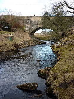 River Dibb at Dibbles Bridge, which carries the B6265 between Pateley Bridge and Threshfield | |
| Location | |
| Country | England |
| Physical characteristics | |
| Source | |
| • location | Grimwith Reservoir |
| • coordinates | 54°4′48″N 1°54′41″W / 54.08000°N 1.91139°W |
| • elevation | 253 metres (830 ft) |
| Mouth | |
• location | River Wharfe nr Appletreewick |
• coordinates | 54°02′28″N 1°56′35″W / 54.0410°N 1.9431°W |
• elevation | 143 metres (469 ft) |
| Length | 5.2 kilometres (3.2 mi) |
| Basin size | 25.5 square kilometres (9.8 sq mi) |
Toponymy edit
The name is possibly derived from the Olde English dib, a dialectical form of dip meaning hollow, or deep place pool.[1][2] The name of Dybb/Dibb is recorded in local 14th century records as Dybbe, a now lost hamlet near Burnsall, where the people who lived there were lead miners.[3]
Course edit
The river starts from the south side of Grimwith Reservoir and flows south-west through Burnett Fold Nook and then south before returning south-west to pass under the B6265 at Dibble's Bridge, which has been the scene of two coach crashes - one in 1925 when seven people were killed, and one in 1975 when 33 people were killed.[4] Below its confluence with Holes Beck, the Ordnance Survey maps show the name of the river changing to Barben Beck.[5] It follows a mostly southerly course through Rough Close Wood and Barnscar Plantation to Rookcroft Wood. It turns west through Sprinsgide Wood and then south-west again past Hartlington Mill, where it was once used to power a 5.5-metre (18 ft) diameter undershot water wheel,[6][7] and under Hartlington Bridge before joining the River Wharfe.[5]
The river flows for 5.2 kilometres (3.2 mi) largely over millstone grit, which overlays limestone and shales.[8][9] A leat used to take water from a high point of the river (between the overflow of the reservoir and Dibbles Bridge) to a lead mine near to Barben Beck.[10]
Ecology edit
The river is noted as having white-clawed crayfish, brown trout and arctic char present.[11][12] The arctic char were introduced into Grimwith Reservoir from Windermere in 1989, 1990, and 1991. Surveys detected the fish in the River Dibb in 1995 and 1998.[13] In 2015, Yorkshire Water agreed to keep a constant flow in the river from Grimwith Reservoir. As the designation of Grimwith Reservoir is one of compensation when needed in times of low water flow in the Wharfe and beyond,[14] the river historically could run dry, making it difficult for wildlife to survive in the river. Yorkshire Water are required to allow 272,760 cubic metres (9,632,000 cu ft) to flow into the River Wharfe from Grimwith Reservoir via the River Dibb on a daily basis.[15][16]
Folklore edit
Dibble's Bridge is sometimes referred to as Devil's Bridge.[2] It is traditionally said to have been built by the Devil for a shoemaker named Ralph Calvert, after Calvert offered the Devil a drink.[17]
Lists edit
Tributaries edit
|
Settlements edit
|
Crossings edit
|
References edit
- ^ "Dibble's Bridge :: Survey of English Place-Names". epns.nottingham.ac.uk. Retrieved 30 August 2022.
- ^ a b Chrystal, Paul (2017). The Place Names of Yorkshire; Cities, Towns, Villages, Rivers and Dales, some Pubs too, in Praise of Yorkshire Ales (1 ed.). Catrine: Stenlake. p. 30. ISBN 9781840337532.
- ^ Speight, Harry (1900). Upper Wharfedale : being a complete account of the history, antiquities and scenery of the picturesque valley of the Wharfe, from Otley to Langstrothdale. London: Elliot Stock. p. 382. OCLC 1158048460.
- ^ "Dibbles Bridge coach crash: Memorial unveiled to 1975 accident". BBC News. 27 May 2022. Retrieved 30 August 2022.
- ^ a b "298" (Map). Nidderdale; Fountains Abbey, Ripon & Pateley Bridge. 1:25,000. Explorer. Ordnance Survey. 2015. ISBN 978-0-319-24550-7.
- ^ Historic England. "Hartlington Mill (Grade II) (1131741)". National Heritage List for England. Retrieved 30 August 2022.
- ^ Johnson, David. "Hartlington Kiln 2010 Excavation Report" (PDF). Retrieved 4 March 2012.
- ^ Chrystal, Paul (2017). The Place Names of Yorkshire; Cities, Towns, Villages, Rivers and Dales, some Pubs too, in Praise of Yorkshire Ales (1 ed.). Catrine: Stenlake. p. 101. ISBN 9781840337532.
- ^ Dakyns, J. R. (August 1877). "II.—A Sketch of the Geology of Keighley, Skipton, and Grassington". Geological Magazine. 4 (8): 350. doi:10.1017/S0016756800149544. S2CID 140537297.
- ^ Raistrick, Arthur (1973). Lead mining in the Mid-Pennines; the mines of Nidderdale, Wharfedale, Airedale, Ribblesdale and Bowland. Truro: Barton. p. 78. ISBN 0851531024.
- ^ Cowx, I. G., ed. (2000). Management and ecology of river fisheries. Malden, Mass.: Fishing News Books. p. 223. ISBN 0470695277.
- ^ Stone, Timothy James (2018). "Impact of flow regulation and habitat improvement on brown trout in Yorkshire rivers". University of Hull. Retrieved 30 August 2022.
- ^ Maitland, P. S.; Winfield, I. J.; McCarthy, I. D.; Igoe, F. (March 2007). "The status of Arctic charr Salvelinus alpinus in Britain and Ireland". Ecology of Freshwater Fish. 16 (1): 6–19. doi:10.1111/j.1600-0633.2006.00167.x.
- ^ Bowtell, Harold D. (1991). Lesser railways of the Yorkshire Dales : and the dam builders in the Age of Steam. Brighton: Plateway Press. p. 157. ISBN 1-871980-09-7.
- ^ "Project restores flow to river after 150 years". Craven Herald. 8 May 2015. Retrieved 30 August 2022.
- ^ "Water Resources Act 1991 (as amended by the". thenational.wales. Retrieved 30 August 2022.
- ^ Ash, Russell (1973). Folklore, Myths and Legends of Britain. Reader's Digest Association Limited. p. 353. ISBN 9780340165973.