


Summary
The River Nadder is a tributary of the River Avon, flowing in south Wiltshire, England.

Course edit
The river flows north from Ludwell to West End where it is joined by the Ferne Brook, close to the Lower Coombe and Ferne Brook Meadows[1] site of special scientific interest (SSSI).[2] At Wardour it is joined by the River Sem. The river then flows east through Tisbury, where it is joined by the Fonthill Brook, and then onto Barford St Martin and Burcombe before reaching Wilton.[3][4][5] Near Quidhampton, the Wylye joins from the north.[6] After passing Harnham, the Nadder joins the Avon near Salisbury Cathedral.[7]
Including its headwaters, the river's length is about 55 km (34 mi).[8][9][10][11]
Water quality edit
The Environment Agency measures the water quality of the river systems in England. Each is given an overall ecological status, which may be one of five levels: high, good, moderate, poor and bad. There are several components that are used to determine this, including biological status, which looks at the quantity and varieties of invertebrates, angiosperms and fish. Chemical status, which compares the concentrations of various chemicals against known safe concentrations, is rated good or fail.[12]
Water quality of the River Nadder in 2019:
| Section | Ecological Status |
Chemical Status |
Overall Status |
Length | Catchment | Channel |
|---|---|---|---|---|---|---|
| Nadder (Headwaters)[13] | Poor | Fail | Poor | 6.698 km (4.162 mi) | 34.713 km2 (13.403 sq mi) | |
| Nadder (Upper)[14] | Moderate | Fail | Moderate | 5.282 km (3.282 mi) | 10.934 km2 (4.222 sq mi) | |
| Nadder (Middle[15] | Moderate | Fail | Moderate | 30.807 km (19.143 mi) | 72.107 km2 (27.841 sq mi) | |
| Nadder (Lower)[16] | Good | Fail | Moderate | 11.951 km (7.426 mi) | 15.021 km2 (5.800 sq mi) |
Image gallery edit
-
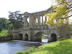 Flowing under the Palladian Bridge at Wilton House
 -
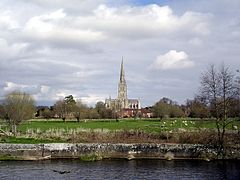 Salisbury Cathedral seen from the banks of the Nadder
 -
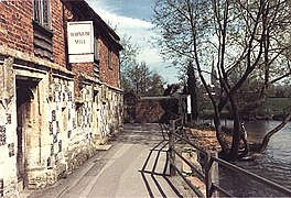 The watermill at Harnham is near where the Nadder meets the Avon
 -
 Reed beds along the banks of the Nadder at Harnham


References edit
- ^ "Lower Coombe and Ferne Brook Meadows" (PDF). naturalengland.org.uk. 25 January 2002. Retrieved 6 May 2019.
- ^ "Lower Coombe and Ferne Brook Meadows" (PDF). Archived from the original (PDF) on 3 March 2016. Retrieved 28 August 2023.
- ^ "View: SU03 (includes: Wilton) - Ordnance Survey 1:25,000 maps of Great Britain, 1937-1961". National Library of Scotland. Retrieved 6 February 2018.
- ^ "Development Brief, Hindon Lane, Tisbury" (PDF). wiltshire.gov.uk. 2006. Retrieved 6 May 2019.
- ^ Wiltshire Archaeological and Natural History Society. Wiltshire archaeological and natural history magazine. London Natural History Museum Library. Devizes : Wiltshire Archaeological and Natural History Society.
- ^ "Wylye (lower)". Environment Agency - Catchment Data Explorer. Retrieved 7 February 2018.
- ^ "View: SU12 - Ordnance Survey 1:25,000 maps of Great Britain, 1937-1961". National Library of Scotland. Retrieved 6 February 2018.
- ^ "Nadder (headwaters)". Environment Agency - Catchment Data Explorer. Retrieved 7 February 2018.
- ^ "Nadder (upper)". Environment Agency - Catchment Data Explorer. Retrieved 7 February 2018.
- ^ "Nadder (middle)". Environment Agency - Catchment Data Explorer. Retrieved 7 February 2018.
- ^ "Nadder (lower)". Environment Agency - Catchment Data Explorer. Retrieved 7 February 2018.
- ^ "Glossary (see Biological quality element; Chemical status; and Ecological status)". Catchment Data Explorer. Environment Agency. 17 February 2016.
 Text was copied from this source, which is available under an Open Government Licence v3.0. © Crown copyright.
- ^ "Nadder (Headwaters)". Catchment Data Explorer. Environment Agency.
- ^ "Nadder (Upper)". Catchment Data Explorer. Environment Agency.
- ^ "Nadder (Middle". Catchment Data Explorer. Environment Agency.
- ^ "Nadder (Lower)". Catchment Data Explorer. Environment Agency.
External links edit
- Discover Nadder - Cranborne Chase AONB
51°03′N 1°48′W / 51.050°N 1.800°W