


Summary
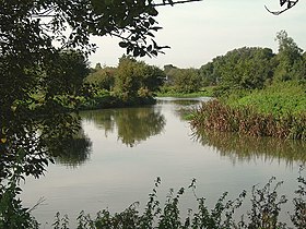
The River Stort is a river in Essex and Hertfordshire, England. It is 24 miles (38 km) long and flows from just south of the village of Langley to the River Lea at Hoddesdon.
| Stort | |
|---|---|
 | |
| Location | |
| Country | United Kingdom |
| Region | Hertfordshire |
| City | Bishop's Stortford |
| Physical characteristics | |
| Source | |
| • location | Near Langley, Essex, England |
| • coordinates | 52°00′10″N 0°04′06″E / 52.0027°N 0.0683°E |
| • elevation | 130 m (430 ft) |
| Mouth | River Lea |
• location | Near Hoddesdon, Hertfordshire |
• coordinates | 51°45′52″N 0°00′51″E / 51.7644°N 0.0141°E |
• elevation | 28 m (92 ft) |
| Length | 38 km (24 mi) |
The river's name is a back-formation from the name of the town of Bishop's Stortford. The 16th-century cartographers Christopher Saxton and William Camden named it the Stort, assuming the town of Stortford was named for its ford.[1] The river was originally called the Stour.[2]
The Stort Navigation is the canalised section of the River Stort running 22 kilometres (14 mi) from Bishop's Stortford to its confluence with the Lee Navigation. It has 15 locks.
Course edit
The Stort rises north of Langley according to OS Explorer map 194 (GR 425358). From Langley, the Stort flows in a generally southerly direction through the villages of Clavering and Manuden and the market town of Bishop's Stortford.
It then flows past Sawbridgeworth, before it changes direction and flows west past Harlow and Roydon. The Stort finally empties into the Lea at Feildes Weir, Hoddesdon. This 14-mile (22-km) long section was canalised in the 18th century as the Stort Navigation.
References edit
External links edit
 Media related to River Stort at Wikimedia Commons
- River Stort Old Postcard images in A Guide to Old Hertfordshire
- Stort River Partnership