
KNOWPIA
WELCOME TO KNOWPIA

Rives-en-Seine 
Summary
Rives-en-Seine (French pronunciation: [ʁiv ɑ̃ sɛn]) is a commune in the department of Seine-Maritime, northern France. The municipality was established on 1 January 2016 by merger of the former communes of Caudebec-en-Caux, Saint-Wandrille-Rançon and Villequier.[3]
Rives-en-Seine | |
|---|---|
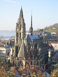 The church in Caudebec | |
Location of Rives-en-Seine .mw-parser-output .locmap .od{position:absolute}.mw-parser-output .locmap .id{position:absolute;line-height:0}.mw-parser-output .locmap .l0{font-size:0;position:absolute}.mw-parser-output .locmap .pv{line-height:110%;position:absolute;text-align:center}.mw-parser-output .locmap .pl{line-height:110%;position:absolute;top:-0.75em;text-align:right}.mw-parser-output .locmap .pr{line-height:110%;position:absolute;top:-0.75em;text-align:left}.mw-parser-output .locmap .pv>div{display:inline;padding:1px}.mw-parser-output .locmap .pl>div{display:inline;padding:1px;float:right}.mw-parser-output .locmap .pr>div{display:inline;padding:1px;float:left}html.skin-theme-clientpref-night .mw-parser-output .od,html.skin-theme-clientpref-night .mw-parser-output .od .pv>div,html.skin-theme-clientpref-night .mw-parser-output .od .pl>div,html.skin-theme-clientpref-night .mw-parser-output .od .pr>div{background:#000;color:#fff}html.skin-theme-clientpref-night .mw-parser-output .locmap{filter:grayscale(0.6)}@media(prefers-color-scheme:dark){html.skin-theme-clientpref-os .mw-parser-output .locmap{filter:grayscale(0.6)}html.skin-theme-clientpref-os .mw-parser-output .od,html.skin-theme-clientpref-os .mw-parser-output .od .pv>div,html.skin-theme-clientpref-os .mw-parser-output .od .pl>div,html.skin-theme-clientpref-os .mw-parser-output .od .pr>div{background:#000;color:#fff}}  Rives-en-Seine  Rives-en-Seine | |
| Coordinates: 49°31′30″N 0°43′23″E / 49.525°N 0.723°E | |
| Country | France |
| Region | Normandy |
| Department | Seine-Maritime |
| Arrondissement | Rouen |
| Canton | Port-Jérôme-sur-Seine |
| Intercommunality | Caux Seine Agglo |
| Government | |
| • Mayor (2020–2026) | Bastien Coriton[1] |
| Area 1 | 34.14 km2 (13.18 sq mi) |
| Population (2021)[2] | 4,078 |
| • Density | 120/km2 (310/sq mi) |
| Time zone | UTC+01:00 (CET) |
| • Summer (DST) | UTC+02:00 (CEST) |
| INSEE/Postal code | 76164 /76490 |
| 1 French Land Register data, which excludes lakes, ponds, glaciers > 1 km2 (0.386 sq mi or 247 acres) and river estuaries. | |
Population edit
| Year | Pop. | ±% p.a. |
|---|---|---|
| 1968 | 4,722 | — |
| 1975 | 4,742 | +0.06% |
| 1982 | 4,430 | −0.97% |
| 1990 | 4,238 | −0.55% |
| 1999 | 4,322 | +0.22% |
| 2007 | 4,264 | −0.17% |
| 2012 | 4,213 | −0.24% |
| 2017 | 4,259 | +0.22% |
| Source: INSEE[4] | ||
See also edit
References edit
Wikimedia Commons has media related to Rives-en-Seine.
- ^ "Répertoire national des élus: les maires" (in French). data.gouv.fr, Plateforme ouverte des données publiques françaises. 13 September 2022.
- ^ "Populations légales 2021". The National Institute of Statistics and Economic Studies. 28 December 2023.
- ^ Arrêté préfectoral 16 December 2015 (in French)
- ^ Population en historique depuis 1968, INSEE