


Summary
Roelofarendsveen (Dutch pronunciation: [ruloːˌfaːrəntsˈfeːn]) is a town in the west of the Netherlands. It is located in the municipality of Kaag en Braassem, South Holland, about 10 km east of Leiden.
Roelofarendsveen | |
|---|---|
Town | |
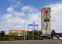 Water tower | |
 Roelofarendsveen Location in the province of South Holland in the Netherlands  Roelofarendsveen Location in the Netherlands | |
| Coordinates: 52°12′N 4°38′E / 52.200°N 4.633°E | |
| Country | Netherlands |
| Province | South Holland |
| Municipality | Kaag en Braassem |
| Area | |
| • Total | 7.76 km2 (3.00 sq mi) |
| Elevation | −0.9 m (−3.0 ft) |
| Population (2021)[1] | |
| • Total | 10,070 |
| • Density | 1,300/km2 (3,400/sq mi) |
| Time zone | UTC+1 (CET) |
| • Summer (DST) | UTC+2 (CEST) |
| Postal code | 2371[1] |
| Dialing code | 071 |
| Major roads | A4 |
History edit
The village was first mentioned in 1575 as "Roelifaerts Veen", and means "bog of Roelof Aertszoon" who was probably the peat concession holder.[3] Roelofarendsveen is a road village which developed along the bank of the Braassemermeer. Later it developed into a horticulture centre.[4]
The polder mill Googermolen was built in 1717. It might have been rebuilt in 1830s. It was definitely restored in 1839. In 1956, a pumping station was added, and the wind mill now operates on a voluntary basis.[5] The Catholic St Petrus' Banden Church is an aisleless church with detached tower built between 1969 and 1970 as a replacement of the 1856 church.[4]
Roelofarendsveen was home to 1,205 people in 1840.[6] After World War II, the town Roelofarendsveen and the village Oude Wetering have merged to form one built-up area.[4]
Gallery edit
-
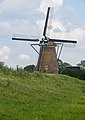 Roelofarendsveen, windmill
 -
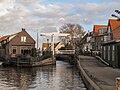 Roelofarendsveen, small bridge in the street


Notable people edit
- Femke Heemskerk, international swimmer, gold medallist in the 100m freestyle event at the 2014 World Short Course Championships
References edit
- ^ a b c "Kerncijfers wijken en buurten 2021". Central Bureau of Statistics. Retrieved 4 May 2022.
minus Oude Wetering
- ^ "Postcodetool for 2371AA". Actueel Hoogtebestand Nederland (in Dutch). Het Waterschapshuis. 24 July 2019. Retrieved 4 May 2022.
- ^ "Roelofarendsveen - (geografische naam)". Etymologiebank (in Dutch). Retrieved 4 May 2022.
- ^ a b c Ronald Stenvert & Sabine Broekhoven (2004). "Roelofsarendsveen" (in Dutch). Zwolle: Waanders. ISBN 90-400-9034-3. Retrieved 4 May 2022.
- ^ "Googermolen". Molen database (in Dutch). Retrieved 4 May 2022.
- ^ "Roelofarendsveen". Plaatsengids (in Dutch). Retrieved 4 May 2022.