


Summary
RopeWalks is a district of Liverpool city centre bounded by Hanover Street to the north-west, Lydia Ann Street to the west, Roscoe Street to the east and Back Bold Street to north-east.
| RopeWalks, Liverpool | |
|---|---|
 Bold Street, Liverpool city centre | |
 RopeWalks, Liverpool Location within Merseyside | |
| Metropolitan borough | |
| Metropolitan county | |
| Region | |
| Country | England |
| Sovereign state | United Kingdom |
| Post town | LIVERPOOL |
| Postcode district | L1 |
| Dialling code | 0151 |
| Police | Merseyside |
| Fire | Merseyside |
| Ambulance | North West |
| UK Parliament | |
RopeWalks is a diverse district encompassing some of the most notable streets and squares in the city centre for independent shopping, cafe and restaurant culture, entertainment and night-time recreation. These include Bold Street, Wood Street, Wolstenholme Square, Fleet Street, Seel Street, Duke Street, Slater Street and Liverpool's Chinatown.[1][2][3]
History edit
The name is derived from the craft of rope-making for sailing ships that dominated the area until the 19th century. It is characterised by its long, straight streets running parallel to each other. The streets were built in this way to allow rope manufacturers to lay the ropes out lengthways during production. There are a number of historic warehouse buildings and it owes much of its character to the rope-making industry.
The area includes the Foundation for Art and Creative Technology, Europe's oldest established Chinatown, the grand façade of St. Luke's bombed-out Church, and a number of cafés, bars and clubs.
Ropes were made in fields but ropemakers bought or rented thin long strips of land. It was the sale of these thin strips, one by one at different times, that led to long thin streets with few interconnections. The streets themselves were not used in manufacture, the roperies pre-dated the streets.[4]
Notable landmarks edit
- Blue Angel (nightclub)
- Church of St Luke, Liverpool ('Bombed-out church')
- City of Liverpool College (Duke Street and Roscoe Street}
- Epstein Theatre
- FACT Liverpool
- Great George Street Congregational Church ('The Blackie')
- Jacaranda Records
- Liverpool Central railway station
- St Peter's Roman Catholic Church
- The Jacaranda
- The Lyceum
- The Whitehouse
Location edit
RopeWalks is located adjacent to Liverpool city centre's main retail area and is bounded by Hanover Street, Back Bold Street, Leece Street, Roscoe Street, Hardy Street, Nelson Street, Upper Pitt Street, Kent Street, Lydia Ann Street, Cleveland Square, Price Street and Hanover Street. At the northern edge is Liverpool Central railway station, at the eastern edge is the Church of St Luke, Liverpool ('Bombed-out church'), to the south east is Great George Street Congregational Church ('The Blackie') and on the eastern edge is Lydia Ann Street.
According to Liverpool's most recent Local Plan, RopeWalks has been set aside by Liverpool City Council for creative and digital businesses, entertainment, nightlife, residential, small-scale shops and services, leisure, hotels, cultural facilities, restaurants and offices.[5][6]

Gallery edit
-
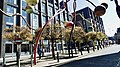 Penelope sculpture, Wolstenholme Square
 -
 Parr Street
 -
 Gradwell Street
 -
 Hanover Street
 -
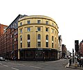 Corner of Duke Street and Hanover Street
 -
 24 Hanover Street
 -
 26 - 30 Hanover Street
 -
 167 - 171 Duke Street, Liverpool 1.jpg
 -
 The Lyceum, Bold Street
 -
 The 'Bombed-out church'
 -
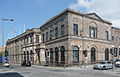 Union News Room
 -
 St Peter's, Seel Street
 -
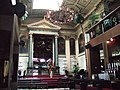 Alma de Cuba
 -
 Bold Street (bottom)


See also edit
References edit
- ^ "Liverpool Local Plan (2013 -2033)" (PDF). Liverpool City Council. Retrieved 23 April 2024.
- ^ "Top spots for new students to get to know across Liverpool". Liverpool John Moores University. Retrieved 23 April 2024.
- ^ "RopeWalks Supplementary Planning Document (Adopted December 2005)" (PDF). Liverpool City Council. Retrieved 23 April 2024.
- ^ Pevsner Liverpool Guide map of roperies
- ^ "Liverpool Local Plan (2013 -2033)" (PDF). Liverpool City Council. Retrieved 24 April 2024.
- ^ "RopeWalks Supplementary Planning Document (Adopted December 2005)" (PDF). Liverpool City Council. Retrieved 24 April 2024.
External links edit
- Visit Liverpool's Ropewalks