


Summary
Roslyakovo (Russian: Росляко́во) was an urban locality (an urban-type settlement) under the administrative jurisdiction of the closed-administrative territorial formation of Severomorsk in Murmansk Oblast, Russia, located on the Kola Peninsula on the Kola Bay, 6 kilometers (3.7 mi) west of Severomorsk proper. It was abolished, with its territory merged into the city of Murmansk, on January 1, 2015.[3] Population: 8,696 (2010 Census);[4] 9,458 (2002 Census);[7] 11,981 (1989 Census).[8]
Roslyakovo
Росляково | |
|---|---|
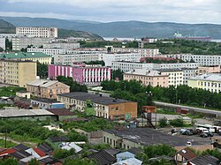 View of Roslyakovo | |
 Coat of arms | |
Location of Roslyakovo .mw-parser-output .locmap .od{position:absolute}.mw-parser-output .locmap .id{position:absolute;line-height:0}.mw-parser-output .locmap .l0{font-size:0;position:absolute}.mw-parser-output .locmap .pv{line-height:110%;position:absolute;text-align:center}.mw-parser-output .locmap .pl{line-height:110%;position:absolute;top:-0.75em;text-align:right}.mw-parser-output .locmap .pr{line-height:110%;position:absolute;top:-0.75em;text-align:left}.mw-parser-output .locmap .pv>div{display:inline;padding:1px}.mw-parser-output .locmap .pl>div{display:inline;padding:1px;float:right}.mw-parser-output .locmap .pr>div{display:inline;padding:1px;float:left}html.skin-theme-clientpref-night .mw-parser-output .od,html.skin-theme-clientpref-night .mw-parser-output .od .pv>div,html.skin-theme-clientpref-night .mw-parser-output .od .pl>div,html.skin-theme-clientpref-night .mw-parser-output .od .pr>div{background:#000;color:#fff}html.skin-theme-clientpref-night .mw-parser-output .locmap{filter:grayscale(0.6)}@media(prefers-color-scheme:dark){html.skin-theme-clientpref-os .mw-parser-output .locmap{filter:grayscale(0.6)}html.skin-theme-clientpref-os .mw-parser-output .od,html.skin-theme-clientpref-os .mw-parser-output .od .pv>div,html.skin-theme-clientpref-os .mw-parser-output .od .pl>div,html.skin-theme-clientpref-os .mw-parser-output .od .pr>div{background:#000;color:#fff}}  Roslyakovo Location of Roslyakovo 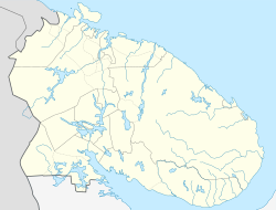 Roslyakovo Roslyakovo (Murmansk Oblast) | |
| Coordinates: 69°02′46″N 33°12′40″E / 69.04611°N 33.21111°E | |
| Country | Russia |
| Federal subject | Murmansk Oblast[1] |
| Founded | 1896[2] |
| Urban-type settlement status since | 1959[2] |
| Abolished | January 1, 2015[3] |
| Population | |
| • Total | 8,696 |
| • Subordinated to | closed administrative-territorial formation of Severomorsk[1] |
| • Urban okrug | Severomorsk Urban Okrug[3] |
| Time zone | UTC+3 (MSK |
| Postal code(s)[6] | 184635 |
| Dialing code(s) | +7 81537 |
| OKTMO ID | 47730000056 |
History edit
It was founded in 1896.[2] The colony of Roslyakovo was one of the twenty-one included into Alexandrovskaya Volost of Alexandrovsky Uyezd, Arkhangelsk Governorate upon its establishment on July 1, 1920.[9] Urban-type settlement status was granted to Roslyakovo in 1959.[2]
Roslyakovo was in jurisdiction of the closed administrative-territorial formation of Severomorsk until January 1, 2015,[1] when it was abolished, with its territory merged into the city of Murmansk.[3]
There is no restaurant or cafe in town. Formerly, there was a medical clinic. There are "a few 7-Eleven-sized grocery stores."[10] The Church of St. Michael the Archangel, founded in 1991, is the only church in the town.[11]
Most of the population are in the Russian Navy, or work as navy contractors. Shipbuilding is a local industry. After merging and enlarging two graving docks for the aircraft carrier Admiral Kuznetsov, Roslyakovo has the largest drydock in European Russia.[12] Rosneft, the state owned oil company, is opening facilities in the town.[10]
Citations edit
- ^ a b c d Decree #603
- ^ a b c d "Росляково". Kola Encyclopedia (in Russian). Archived from the original on February 17, 2015.
- ^ a b c d Law #1812-01-ZMO
- ^ a b Russian Federal State Statistics Service (2011). Всероссийская перепись населения 2010 года. Том 1 [2010 All-Russian Population Census, vol. 1]. Всероссийская перепись населения 2010 года [2010 All-Russia Population Census] (in Russian). Federal State Statistics Service.
- ^ "Об исчислении времени". Официальный интернет-портал правовой информации (in Russian). June 3, 2011. Retrieved January 19, 2019.
- ^ Почта России. Информационно-вычислительный центр ОАСУ РПО. (Russian Post). Поиск объектов почтовой связи (Postal Objects Search) (in Russian)
- ^ Russian Federal State Statistics Service (May 21, 2004). Численность населения России, субъектов Российской Федерации в составе федеральных округов, районов, городских поселений, сельских населённых пунктов – районных центров и сельских населённых пунктов с населением 3 тысячи и более человек [Population of Russia, Its Federal Districts, Federal Subjects, Districts, Urban Localities, Rural Localities—Administrative Centers, and Rural Localities with Population of Over 3,000] (XLS). Всероссийская перепись населения 2002 года [All-Russia Population Census of 2002] (in Russian).
- ^ Всесоюзная перепись населения 1989 г. Численность наличного населения союзных и автономных республик, автономных областей и округов, краёв, областей, районов, городских поселений и сёл-райцентров [All Union Population Census of 1989: Present Population of Union and Autonomous Republics, Autonomous Oblasts and Okrugs, Krais, Oblasts, Districts, Urban Settlements, and Villages Serving as District Administrative Centers]. Всесоюзная перепись населения 1989 года [All-Union Population Census of 1989] (in Russian). Институт демографии Национального исследовательского университета: Высшая школа экономики [Institute of Demography at the National Research University: Higher School of Economics]. 1989 – via Demoscope Weekly.
- ^ Administrative-Territorial Division of Murmansk Oblast, p. 66
- ^ a b Kelly, Mary Louise (August 4, 2016). "A Once-Closed Russian Military Town In The Arctic Opens To The World". NPR. Retrieved August 4, 2016.
- ^ Росляково. Церковь Михаила Архангела. [Roslyakovo. The Church of St. Michael the Archangel.]. Sobory.ru (in Russian). Archived from the original on December 21, 2017. Retrieved April 8, 2019.
- ^ Russia’s Cursed Aircraft Carrier Is Finally In A Drydock That Can’t Sink | The Drive | Published May 20, 2022
- Official website of Murmansk Oblast. Registry of the Administrative-Territorial Structure of Murmansk Oblast (in Russian)
- Архивный отдел Администрации Мурманской области. Государственный Архив Мурманской области (1995). Административно-территориальное деление Мурманской области (1920—1993 гг.). Справочник. Мурманск: Мурманское издательско-полиграфическое предприятие "Север".
- Мурманская областная Дума. Закон №1812-01-ЗМО от 19 декабря 2014 г. «Об упразднении населённого пункта Мурманской области и о внесении изменений в отдельные законодательные акты Мурманской области». Вступил в силу 1 января 2015 г. Опубликован: «Мурманский Вестник», №246–247, с. 56, 25 декабря 2014 г. (Murmansk Oblast Duma. Law #1812-01-ZMO of December 19, 2014 On Abolishing an Inhabited Locality in Murmansk Oblast and on Amending Various Legislative Acts of Murmansk Oblast. Effective as of January 1, 2015.).
- Президент Российской Федерации. Указ №603 от 1 сентября 2014 г. «О преобразовании закрытого административно-территориального образования — города Североморска Мурманской области». Вступил в силу со дня подписания. Опубликован: Официальный интернет-портал правовой информации http://www.pravo.gov.ru, 2 сентября 2014 г. (President of the Russian Federation. Decree #603 of September 1, 2014 On the Transformation of the Closed Administrative-Territorial Formation—the Town of Severomorsk in Murmansk Oblast. Effective as of the date of signing.).