


Summary
Rottum (or Röppen) is a small village on an artificial dwelling hill between Kantens and Usquert in the municipality of Het Hogeland, falling under the province Groningen in the Netherlands. It had a population of around 85 in January 2017.[3]
Rottum | |
|---|---|
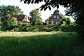
 A tiny house, Jan Boer's bust, and the church in the background | |
 Rottum Location of Rottum in the province of Groningen  Rottum Rottum (Netherlands) | |
| Coordinates: 53°22′55″N 6°37′13″E / 53.38194°N 6.62028°E | |
| Country | Netherlands |
| Province | Groningen |
| Municipality | Het Hogeland |
| Area | |
| • Total | 0.12 km2 (0.05 sq mi) |
| Elevation | 0.8 m (2.6 ft) |
| Population (2021)[1] | |
| • Total | 90 |
| • Density | 750/km2 (1,900/sq mi) |
| Postal code | 9998[1] |
| Dialing code | 0595 |
History edit
Heathen chapel edit
The village was founded on a clay bank of the Fivel estuary and the Wadden Sea. Since high tides were threatening the early inhabitants they raised its height with manure and waste: this way an artificial dwelling hill was created. On top of the artificial dwelling hill eventually a heathen chapel was located, according to the biography of the missionary Ludger. The name "Rottum" could be derived from "rot Heim", which can be translated as "red dwelling-place".
Monastery edit
St. Juliana's Abbey was a Benedictine monastery, probably founded between 1195 and 1210 by monks from the Benedictine Werden Abbey in Germany. The monastery was demolished at the end of the 1800s.
Rottumeroog or Rottum, an island in the Waddenzee, is named after the village since the monastery was two-thirds owner of the island. Near the village the nunnery named Bethlehem was located.
Protestant church edit
In 1889 a Protestant church was built on the same location as the monastery.
The poet Jan Boer was born in Rottum. In 1999 the sculptor Greet Grottendieck was asked to make a bust of Jan Boer to celebrate the 100th anniversary of his day of birth.
Gallery edit
-
 Church of Rottum
 -
 Former brick works
 -
 Excavated terp
 -
 View on the monastery (1854)


References edit
External links edit
- Official website
53°22′55″N 6°37′13″E / 53.38194°N 6.62028°E