


Summary
Rubiera (Reggiano: Rubēra) is a comune (municipality) in the Province of Reggio Emilia in the Italian region Emilia-Romagna, located on the Via Emilia about 50 kilometres (31 mi) northwest of Bologna and about 13 kilometres (8 mi) southeast of Reggio Emilia.
Rubiera | |
|---|---|
| Comune di Rubiera | |
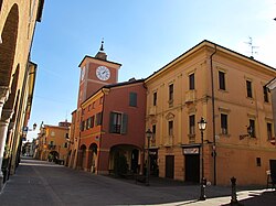 Rubiera. | |
 Coat of arms | |
Location of Rubiera .mw-parser-output .locmap .od{position:absolute}.mw-parser-output .locmap .id{position:absolute;line-height:0}.mw-parser-output .locmap .l0{font-size:0;position:absolute}.mw-parser-output .locmap .pv{line-height:110%;position:absolute;text-align:center}.mw-parser-output .locmap .pl{line-height:110%;position:absolute;top:-0.75em;text-align:right}.mw-parser-output .locmap .pr{line-height:110%;position:absolute;top:-0.75em;text-align:left}.mw-parser-output .locmap .pv>div{display:inline;padding:1px}.mw-parser-output .locmap .pl>div{display:inline;padding:1px;float:right}.mw-parser-output .locmap .pr>div{display:inline;padding:1px;float:left}html.skin-theme-clientpref-night .mw-parser-output .od,html.skin-theme-clientpref-night .mw-parser-output .od .pv>div,html.skin-theme-clientpref-night .mw-parser-output .od .pl>div,html.skin-theme-clientpref-night .mw-parser-output .od .pr>div{background:#000;color:#fff}html.skin-theme-clientpref-night .mw-parser-output .locmap{filter:grayscale(0.6)}@media(prefers-color-scheme:dark){html.skin-theme-clientpref-os .mw-parser-output .locmap{filter:grayscale(0.6)}html.skin-theme-clientpref-os .mw-parser-output .od,html.skin-theme-clientpref-os .mw-parser-output .od .pv>div,html.skin-theme-clientpref-os .mw-parser-output .od .pl>div,html.skin-theme-clientpref-os .mw-parser-output .od .pr>div{background:#000;color:#fff}}  Rubiera Location of Rubiera in Italy  Rubiera Rubiera (Emilia-Romagna) | |
| Coordinates: 44°39′N 10°47′E / 44.650°N 10.783°E | |
| Country | Italy |
| Region | Emilia-Romagna |
| Province | Reggio Emilia (RE) |
| Frazioni | Fontana, San Faustino, Sant'Agata |
| Government | |
| • Mayor | Emanuele Cavallaro |
| Area | |
| • Total | 25.3 km2 (9.8 sq mi) |
| Elevation | 41 m (135 ft) |
| Population (31 December 2016)[2] | |
| • Total | 14,882 |
| • Density | 590/km2 (1,500/sq mi) |
| Demonym | Rubieresi |
| Time zone | UTC+1 (CET) |
| • Summer (DST) | UTC+2 (CEST) |
| Postal code | 42048 |
| Dialing code | 0522 |
| Patron saint | Saint Blaise |
| Saint day | February 3 |
| Website | Official website |
History edit
The original name of the city was Corte de Herberia, probably derived from the Celtic er-beria, meaning "in the middle of the plain". The Roman emperors Gallienus and Valerianus built a bridge over the Secchia river at this location in AD 259.
The first historical mention of Rubiera is from 915, at which time it was a fief of the Supponidi family; the city later became a fief of the Obertenghi family. After a period of decline, it recovered some importance in the 12th century under the comune of Reggio Emilia, due to its strategic position and the fact that the city had a castrum (castle) and massive walls. At later times it was a possession of the House of Este, a Papal possession, and part of the Duchy of Modena and Reggio, during which period the castle was used as a prison.
Among the churches in the community are:[3]
- Santissima Annunziata (18th century)
- Santi Faustino e Giovita (10th century)
- Sant'Agata a Casale (16th century)
- Parish church (18th century)
Sports edit
Rubiera is the hometown of Stefano Baldini, European and Olympic marathon champion. Rubiera's handball team (Pallamano Secchia) has played in the Italian serie A every year since 1982.
Twin towns edit
References edit
External links edit
- Official website