


Summary
Rudston is a small village and civil parish in the East Riding of Yorkshire, England. It is situated between Driffield and Bridlington approximately 6 miles (10 kilometres) west of Bridlington, and lies on the B1253 road. The Gypsey Race (an intermittent stream) runs through the village, which lies in the Great Wold Valley. There are a number of Neolithic sites associated with the stream and its valley. It is the current Seat of the Clan Macdonald of Sleat, the head of the family residing at Thorpe Hall.
| Rudston | |
|---|---|
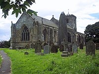 All Saints' Church, Rudston | |
 Rudston Location within the East Riding of Yorkshire | |
| Population | 409 (2011 census)[1] |
| OS grid reference | TA096676 |
| Civil parish |
|
| Unitary authority | |
| Ceremonial county | |
| Region | |
| Country | England |
| Sovereign state | United Kingdom |
| Post town | DRIFFIELD |
| Postcode district | YO25 |
| Dialling code | 01262 |
| Police | Humberside |
| Fire | Humberside |
| Ambulance | Yorkshire |
| UK Parliament | |


According to the 2011 UK census, Rudston parish had a population of 409,[1] an increase on the 2001 UK census figure of 390.[2]
From the medieval era until the 19th century Rudston was part of Dickering Wapentake.[3] Between 1894 and 1974 Rudston was a part of the Bridlington Rural District, in the East Riding of Yorkshire.[4] From 1974 it was part of the Borough of North Wolds (later Borough of East Yorkshire), in the county of Humberside until the East Riding was re-established in 1996.
History edit
The place-name 'Rudston' is first attested in the Domesday Book of 1086, and means 'rood' or 'cross' stone, referring to the monolith.[5] However, the name 'rud' derives from Old Norse ruð, meaning a clearing or pasture. So the place name could be stone in the clearing, Ruðstane.
Ancient remains edit
The Rudston Monolith stands in the parish churchyard. At over 25 feet (7.5 metres) tall, it is the tallest standing stone in England, and gave the village its name; it is Grade I listed.[6][7]
Southside Mount round barrow is situated to the south west of the village close to Woldgate reservoir.[8]
Rudston is the centre of an unparalleled grouping of four Neolithic cursus monuments: cursus A,[9] cursus B,[10] cursus C[11] and cursus D.[12] At least one end of each cursus rests on an elevated chalk ridge on the sides of the Great Wold Valley. Cursuses A and C cross the Gypsey Race, whilst the other ends of cursuses B and D probably lie under the village.
Rudston Roman villa, noted for its mosaics, was first excavated in 1839. It was subsequently re-excavated in the 1930s, 1960s and 1970s.[13][14] The mosaics are now in the Hull and East Riding Museum.[15]
Parish church edit
Rudston Grade I listed Anglican parish church is dedicated to All Saints.[16] Of 14th-century origin, it was restored in 1861 by George Fowler Jones.[17] It contains the gigantic organ, originally of four manuals, given by Sir Alexander McDonald of the Isles. Now a two-manual instrument, it stands at the west end of the church in the original case.[18] The author Winifred Holtby is buried in the church graveyard.[19] Since September 2014, the North Aisle of the church has a small heritage area including a 3D map of the village with sites of interest noted and a set of information boards about the history of the village.[20]
Thorpe Hall to the east of the village was designated a Grade II* listed building in 1952 and is now recorded in the National Heritage List for England, maintained by Historic England.[21] William Bosville (d.1813) was the last of his family to own it, and he bequeathed it to his nephew Godfrey Macdonald, 3rd Baron Macdonald of Sleat (1775–1832), whose descendants own it today.
References edit
- ^ a b UK Census (2011). "Local Area Report – Rudston Parish (1170211250)". Nomis. Office for National Statistics. Retrieved 24 February 2018.
- ^ UK Census (2001). "Local Area Report – Rudston Parish (00FB121)". Nomis. Office for National Statistics. Retrieved 25 September 2019.
- ^ "Dickering-Wap through time". A Vision of Britain Through Time. University of Portsmouth. Retrieved 24 November 2019.
- ^ "Bridlington RD". A Vision of Britain Through Time. University of Portsmouth. Archived from the original on 10 February 2012. Retrieved 11 April 2013.
- ^ Ekwall, Eilert (1960). The concise Oxford dictionary of English place-names (4 ed.). Oxford: Oxford University Press. p. 395. ISBN 0-19-869103-3.
- ^ Historic England. "Rudston Monolith (79482)". Research records (formerly PastScape). Retrieved 28 April 2013.
- ^ Historic England. "Monolith approximately 7 Metres North of Church of All Saints, Rudston (1083402)". National Heritage List for England. Retrieved 16 April 2012.
- ^ Historic England. "South Side Mount round barrow, 350m north west of Woldgate reservoir, Rudston (1005232)". National Heritage List for England. Retrieved 5 May 2019.
- ^ Historic England. "Rudston Cursus A (79500)". Research records (formerly PastScape). Retrieved 28 April 2013.
- ^ Historic England. "Rudston Cursus B (1036040)". Research records (formerly PastScape). Retrieved 28 April 2013.
- ^ Historic England. "Rudston Cursus C (1036047)". Research records (formerly PastScape). Retrieved 28 April 2013.
- ^ Historic England. "Rudston Cursus D (1036049)". Research records (formerly PastScape). Retrieved 28 April 2013.
- ^ "Rudston Charioteer Mosaic". A History of the World. BBC. Retrieved 16 April 2012.
- ^ "Roman Villa, Rudston, East Yorkshire". Roman-Britain.org. Retrieved 16 April 2012.
- ^ Smith, David (2005). Roman Mosaics at Hull. pp. 9ff. ISBN 0904490-34-3.
- ^ Historic England. "Church of All Saints (1162387)". National Heritage List for England. Retrieved 16 April 2012.
- ^ Pevsner, Nikolaus (1975) [1972]. The Buildings of England. Yorkshire: York and the East Riding (reprint). Pevsner Architectural Guides. Penguin. p. 332. ISBN 0140710434.
- ^ "History of All Saints Church - Rudston". www.rudston.org.uk. Retrieved 20 May 2023.
- ^ "South Riding hits the spot". The Guardian. 3 March 2011. Retrieved 30 December 2020.
- ^ "Rudston Heritage Centre". Retrieved 3 February 2016.
- ^ Historic England. "Thorpe Hall (1346645)". National Heritage List for England. Retrieved 16 August 2013.
- Gazetteer — A–Z of Towns Villages and Hamlets. East Riding of Yorkshire Council. 2006. p. 10.
External links edit
![]() Media related to Rudston at Wikimedia Commons
Media related to Rudston at Wikimedia Commons
- Rudston in the Domesday Book
- The Rudston Village website
- Rudston Roman Villa