
KNOWPIA
WELCOME TO KNOWPIA

Ruffec, Indre 
Summary
Ruffec (French pronunciation: [ʁyfɛk]) is a commune in the Indre department in central France.
Ruffec | |
|---|---|
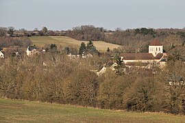 A general view of Ruffec | |
Location of Ruffec .mw-parser-output .locmap .od{position:absolute}.mw-parser-output .locmap .id{position:absolute;line-height:0}.mw-parser-output .locmap .l0{font-size:0;position:absolute}.mw-parser-output .locmap .pv{line-height:110%;position:absolute;text-align:center}.mw-parser-output .locmap .pl{line-height:110%;position:absolute;top:-0.75em;text-align:right}.mw-parser-output .locmap .pr{line-height:110%;position:absolute;top:-0.75em;text-align:left}.mw-parser-output .locmap .pv>div{display:inline;padding:1px}.mw-parser-output .locmap .pl>div{display:inline;padding:1px;float:right}.mw-parser-output .locmap .pr>div{display:inline;padding:1px;float:left}html.skin-theme-clientpref-night .mw-parser-output .od,html.skin-theme-clientpref-night .mw-parser-output .od .pv>div,html.skin-theme-clientpref-night .mw-parser-output .od .pl>div,html.skin-theme-clientpref-night .mw-parser-output .od .pr>div{background:#000;color:#fff}html.skin-theme-clientpref-night .mw-parser-output .locmap{filter:grayscale(0.6)}@media(prefers-color-scheme:dark){html.skin-theme-clientpref-os .mw-parser-output .locmap{filter:grayscale(0.6)}html.skin-theme-clientpref-os .mw-parser-output .od,html.skin-theme-clientpref-os .mw-parser-output .od .pv>div,html.skin-theme-clientpref-os .mw-parser-output .od .pl>div,html.skin-theme-clientpref-os .mw-parser-output .od .pr>div{background:#000;color:#fff}}  Ruffec  Ruffec | |
| Coordinates: 46°37′48″N 1°10′20″E / 46.63°N 1.1722°E | |
| Country | France |
| Region | Centre-Val de Loire |
| Department | Indre |
| Arrondissement | Le Blanc |
| Canton | Le Blanc |
| Intercommunality | Brenne Val de Creuse |
| Government | |
| • Mayor (2020–2026) | Édith Vachaud[1] |
| Area 1 | 40.93 km2 (15.80 sq mi) |
| Population (2021)[2] | 575 |
| • Density | 14/km2 (36/sq mi) |
| Time zone | UTC+01:00 (CET) |
| • Summer (DST) | UTC+02:00 (CEST) |
| INSEE/Postal code | 36176 /36300 |
| Elevation | 77–141 m (253–463 ft) (avg. 87 m or 285 ft) |
| 1 French Land Register data, which excludes lakes, ponds, glaciers > 1 km2 (0.386 sq mi or 247 acres) and river estuaries. | |
Geography edit
The commune is located in the parc naturel régional de la Brenne.
Population edit
| Year | Pop. | ±% p.a. |
|---|---|---|
| 1968 | 635 | — |
| 1975 | 607 | −0.64% |
| 1982 | 519 | −2.21% |
| 1990 | 594 | +1.70% |
| 1999 | 525 | −1.36% |
| 2009 | 644 | +2.06% |
| 2014 | 606 | −1.21% |
| 2020 | 580 | −0.73% |
| Source: INSEE[3] | ||
See also edit
References edit
- ^ "Répertoire national des élus: les maires". data.gouv.fr, Plateforme ouverte des données publiques françaises (in French). 2 December 2020.
- ^ "Populations légales 2021". The National Institute of Statistics and Economic Studies. 28 December 2023.
- ^ Population en historique depuis 1968, INSEE
Wikimedia Commons has media related to Ruffec (Indre).