
KNOWPIA
WELCOME TO KNOWPIA

Rustrel 
Summary
Rustrel (French pronunciation: [ʁystʁɛl]; Occitan: Rustrèu) is a commune in the Vaucluse department in the Provence-Alpes-Côte d'Azur region of Southeastern France. In 2017, it had a population of 688.
Rustrel
Rustrèu (Occitan) | |
|---|---|
 The Château de Rustrel, a historic monument which houses the town hall | |
 Coat of arms | |
Location of Rustrel .mw-parser-output .locmap .od{position:absolute}.mw-parser-output .locmap .id{position:absolute;line-height:0}.mw-parser-output .locmap .l0{font-size:0;position:absolute}.mw-parser-output .locmap .pv{line-height:110%;position:absolute;text-align:center}.mw-parser-output .locmap .pl{line-height:110%;position:absolute;top:-0.75em;text-align:right}.mw-parser-output .locmap .pr{line-height:110%;position:absolute;top:-0.75em;text-align:left}.mw-parser-output .locmap .pv>div{display:inline;padding:1px}.mw-parser-output .locmap .pl>div{display:inline;padding:1px;float:right}.mw-parser-output .locmap .pr>div{display:inline;padding:1px;float:left}html.skin-theme-clientpref-night .mw-parser-output .od,html.skin-theme-clientpref-night .mw-parser-output .od .pv>div,html.skin-theme-clientpref-night .mw-parser-output .od .pl>div,html.skin-theme-clientpref-night .mw-parser-output .od .pr>div{background:#000;color:#fff}html.skin-theme-clientpref-night .mw-parser-output .locmap{filter:grayscale(0.6)}@media(prefers-color-scheme:dark){html.skin-theme-clientpref-os .mw-parser-output .locmap{filter:grayscale(0.6)}html.skin-theme-clientpref-os .mw-parser-output .od,html.skin-theme-clientpref-os .mw-parser-output .od .pv>div,html.skin-theme-clientpref-os .mw-parser-output .od .pl>div,html.skin-theme-clientpref-os .mw-parser-output .od .pr>div{background:#000;color:#fff}}  Rustrel  Rustrel | |
| Coordinates: 43°55′31″N 5°29′09″E / 43.9253°N 5.4858°E | |
| Country | France |
| Region | Provence-Alpes-Côte d'Azur |
| Department | Vaucluse |
| Arrondissement | Apt |
| Canton | Apt |
| Intercommunality | Pays d'Apt-Luberon |
| Government | |
| • Mayor (2020–2026) | Pierre Tartanson[1] |
| Area 1 | 28.26 km2 (10.91 sq mi) |
| Population (2021)[2] | 678 |
| • Density | 24/km2 (62/sq mi) |
| Time zone | UTC+01:00 (CET) |
| • Summer (DST) | UTC+02:00 (CEST) |
| INSEE/Postal code | 84103 /84400 |
| Elevation | 279–1,073 m (915–3,520 ft) (avg. 422 m or 1,385 ft) |
| 1 French Land Register data, which excludes lakes, ponds, glaciers > 1 km2 (0.386 sq mi or 247 acres) and river estuaries. | |
Sights edit
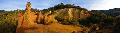
This village is famous for its ochre, which many people come to visit in the French Colorado.

See also edit
References edit
- ^ "Répertoire national des élus: les maires" (in French). data.gouv.fr, Plateforme ouverte des données publiques françaises. 13 September 2022.
- ^ "Populations légales 2021". The National Institute of Statistics and Economic Studies. 28 December 2023.
Wikimedia Commons has media related to Rustrel.