
KNOWPIA
WELCOME TO KNOWPIA

Sa Pobla 
Summary
Sa Pobla (Catalan pronunciation: [sə ˈpob.blə]) is a small municipality in the district of Raiguer on Majorca, one of the Balearic Islands. It is a terminus on the Majorca rail network.
Sa Pobla | |
|---|---|
 Flag  Coat of arms | |
 Location of Sa Pobla in Mallorca | |
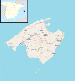 Sa Pobla Location in Majorca  Sa Pobla Sa Pobla (Balearic Islands)  Sa Pobla Sa Pobla (Spain) | |
| Coordinates: 39°46′9″N 3°1′21″E / 39.76917°N 3.02250°E | |
| Country | Spain |
| Autonomous community | Balearic Islands |
| Province | Balearic Islands |
| Comarca | Raiguer |
| Judicial district | Inca |
| Government | |
| • Mayor | Joan Comas Reus |
| Area | |
| • Total | 48.59 km2 (18.76 sq mi) |
| Elevation | 28 m (92 ft) |
| Population (2018)[1] | |
| • Total | 13,026 |
| • Density | 270/km2 (690/sq mi) |
| Demonym | Poblers |
| Time zone | UTC+1 (CET) |
| • Summer (DST) | UTC+2 (CEST) |
| Postal code | 07420 |
The town is in the north of the island. With an area of 48.53 square kilometres (18.74 sq mi), stretching from the Serra de Tramuntana, the Plan and the Bay of Alcúdia. It comprises three very different areas: the Marjal, fertile plains in large part devoted to irrigated agriculture; l 'lagoon, a large area of scenic and ecological value where the streams and San Miguel de Muro (of Almadrà).
References edit
- ^ Municipal Register of Spain 2018. National Statistics Institute.
External links edit
- Official website