


Summary
Sabtang, officially the Municipality of Sabtang (Ivatan: Kavahayan nu Sabtang; Tagalog: Bayan ng Sabtang), is a 6th class municipality in the province of Batanes, Philippines. According to the 2020 census, it has a population of 1,696 people.[4]
Sabtang
San Vicente de Sabtan | |
|---|---|
| Municipality of Sabtang | |
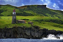 Lighthouse at Sabtang Island | |
 Flag  Seal | |
 Map of Batanes with Sabtang highlighted | |
OpenStreetMap .mw-parser-output .locmap .od{position:absolute}.mw-parser-output .locmap .id{position:absolute;line-height:0}.mw-parser-output .locmap .l0{font-size:0;position:absolute}.mw-parser-output .locmap .pv{line-height:110%;position:absolute;text-align:center}.mw-parser-output .locmap .pl{line-height:110%;position:absolute;top:-0.75em;text-align:right}.mw-parser-output .locmap .pr{line-height:110%;position:absolute;top:-0.75em;text-align:left}.mw-parser-output .locmap .pv>div{display:inline;padding:1px}.mw-parser-output .locmap .pl>div{display:inline;padding:1px;float:right}.mw-parser-output .locmap .pr>div{display:inline;padding:1px;float:left}html.skin-theme-clientpref-night .mw-parser-output .od,html.skin-theme-clientpref-night .mw-parser-output .od .pv>div,html.skin-theme-clientpref-night .mw-parser-output .od .pl>div,html.skin-theme-clientpref-night .mw-parser-output .od .pr>div{background:#000;color:#fff}html.skin-theme-clientpref-night .mw-parser-output .locmap{filter:grayscale(0.6)}@media(prefers-color-scheme:dark){html.skin-theme-clientpref-os .mw-parser-output .locmap{filter:grayscale(0.6)}html.skin-theme-clientpref-os .mw-parser-output .od,html.skin-theme-clientpref-os .mw-parser-output .od .pv>div,html.skin-theme-clientpref-os .mw-parser-output .od .pl>div,html.skin-theme-clientpref-os .mw-parser-output .od .pr>div{background:#000;color:#fff}}  Sabtang Location within the Philippines | |
| Coordinates: 20°20′06″N 121°52′19″E / 20.335°N 121.872°E | |
| Country | Philippines |
| Region | Cagayan Valley |
| Province | Batanes |
| District | Lone district |
| Barangays | 6 (see Barangays) |
| Government | |
| • Type | Sangguniang Bayan |
| • Mayor | Prescila A. Babalo |
| • Vice Mayor | Clemente C. Ladreza Jr. |
| • Representative | Ciriaco A. Gato Jr. |
| • Municipal Council | Members |
| • Electorate | 1,455 voters (2022) |
| Area | |
| • Total | 40.70 km2 (15.71 sq mi) |
| Elevation | 15.7 m (51.5 ft) |
| Highest elevation | 980 m (3,220 ft) |
| Lowest elevation | 0 m (0 ft) |
| Population (2020 census)[4] | |
| • Total | 1,696 |
| • Density | 42/km2 (110/sq mi) |
| • Households | 492 |
| Economy | |
| • Income class | 6th municipal income class |
| • Poverty incidence | 21.71 |
| • Revenue | ₱ 55.27 million (2020) |
| • Assets | ₱ 94.94 million (2020) |
| • Expenditure | ₱ 50.87 million (2020) |
| • Liabilities | ₱ 61.34 million (2020) |
| Service provider | |
| • Electricity | Batanes Electric Cooperative (BATANELCO) |
| Time zone | UTC+8 (PST) |
| ZIP code | 3904 |
| PSGC | 020905000 |
| IDD : area code | +63 (0)78 |
| Native languages | Ivatan Tagalog Ilocano |
| Website | www |
The southernmost island municipality of the Batanes island group, Sabtang comprises primarily Sabtang Island, as well as two nearby smaller and uninhabited islands: Ivuhos and Dequey. The municipality is known for its lighthouse and the old stone houses of the Ivatan villages of Chavayan and Savidug. Like Batan Island to the north, Sabtang also has a few Mission-style churches and white sand beaches.
History edit

The Spanish missionary Fr. Artiquez first visited the Island of Sabtang in 1786[6] after receiving an affirmative response from the islanders to learn about the Christian faith. The success of the first visit led to two more evangelical trips resulting in the baptism of 181 children and the study of the catechism among the adult natives. The evangelization of Sabtang was cut short due to the failing health of the Spanish missionaries. For this, the inhabitants of Sabtang remained faithful to old traditions especially in the administration of justice by vendetta and murder.[6]
In 1791, the then most powerful chief in Sabtang named Aman Dangat showed defiance of the government of Governor Joaquin del Castillo by killing the Spanish soldiers who went to Sabtang to procure supplies. Lieutenant Tomas Nuñez led the troops to capture the rebels. Aman Dangat was put to trial and allegedly admitted to the crime. A religious Spanish recorder later claimed that Aman Dangat asked to be baptized. There is no evidence of this outside of the claim. The inhabitants of Sabtang were then forced to resettle in San Vicente and San Felix in Ivana to be better controlled by the Spanish colonizers.[6]
Some forty years after the resettlement, the Sabteños were allowed to visit their native island and gradually these visits allowed them to build homes in their erstwhile land. The government allowed this to happen on the condition that houses should be constructed in lowlands.[6] To sustain the spiritual care for the Sabteños, a new mission was opened in Sabtang in 1845 under the patronage of Saint Vincent Ferrer with Fr. Antonio Vicente as its first vicar. Fr. Vicente is credited to have built the Sabtang Church, together with a convent, a school, and a courthouse.[6]
Geography edit
Sabtang is located at 20°20′06″N 121°52′19″E / 20.335°N 121.872°E.
According to the Philippine Statistics Authority, the municipality has a land area of 40.70 square kilometres (15.71 sq mi) [7] constituting 18.58% of the 219.01-square-kilometre- (84.56 sq mi) total area of Batanes.
Barangays edit
Sabtang is politically subdivided into 6 barangays.[8] These barangays are headed by elected officials: Barangay Captain, Barangay Council, whose members are called Barangay Councilors. All are elected every three years.
| PSGC | Barangay | Population | ±% p.a. | |||
|---|---|---|---|---|---|---|
| 2020[4] | 2010[9] | |||||
| 020905001 | Chavayan | 9.3% | 157 | 169 | −0.73% | |
| 020905002 | Malakdang (Poblacion) | 13.8% | 234 | 245 | −0.46% | |
| 020905003 | Nakanmuan | 8.4% | 142 | 134 | 0.58% | |
| 020905004 | Savidug | 11.9% | 201 | 190 | 0.56% | |
| 020905005 | Sinakan (Poblacion) | 30.0% | 509 | 552 | −0.81% | |
| 020905006 | Sumnanga | 22.3% | 378 | 347 | 0.86% | |
| Total | 1,696 | 1,637 | 0.35% | |||
Climate edit
| Climate data for Sabtang, Batanes | |||||||||||||
|---|---|---|---|---|---|---|---|---|---|---|---|---|---|
| Month | Jan | Feb | Mar | Apr | May | Jun | Jul | Aug | Sep | Oct | Nov | Dec | Year |
| Mean daily maximum °C (°F) | 23 (73) |
23 (73) |
24 (75) |
26 (79) |
28 (82) |
29 (84) |
29 (84) |
29 (84) |
28 (82) |
27 (81) |
26 (79) |
24 (75) |
26 (79) |
| Mean daily minimum °C (°F) | 22 (72) |
22 (72) |
23 (73) |
25 (77) |
27 (81) |
28 (82) |
28 (82) |
28 (82) |
27 (81) |
26 (79) |
25 (77) |
23 (73) |
25 (78) |
| Average precipitation mm (inches) | 44 (1.7) |
35 (1.4) |
29 (1.1) |
48 (1.9) |
204 (8.0) |
238 (9.4) |
291 (11.5) |
325 (12.8) |
304 (12.0) |
202 (8.0) |
141 (5.6) |
60 (2.4) |
1,921 (75.8) |
| Average rainy days | 11.1 | 9.1 | 8.3 | 9.2 | 15.7 | 17.1 | 19.4 | 21.9 | 21.1 | 18.4 | 16.3 | 12.4 | 180 |
| Source: Meteoblue[10] | |||||||||||||
Demographics edit
| Year | Pop. | ±% p.a. |
|---|---|---|
| 1903 | 1,763 | — |
| 1918 | 1,665 | −0.38% |
| 1939 | 1,844 | +0.49% |
| 1948 | 1,656 | −1.19% |
| 1960 | 1,766 | +0.54% |
| 1970 | 1,359 | −2.58% |
| 1975 | 1,375 | +0.24% |
| 1980 | 1,409 | +0.49% |
| 1990 | 1,737 | +2.12% |
| 1995 | 1,434 | −3.53% |
| 2000 | 1,678 | +3.43% |
| 2007 | 1,465 | −1.85% |
| 2010 | 1,637 | +4.12% |
| 2015 | 1,621 | −0.19% |
| 2020 | 1,696 | +0.89% |
| Source: Philippine Statistics Authority[11][9][12][13] | ||
In the 2020 census, Sabtang had a population of 1,696.[4] The population density was 42 inhabitants per square kilometre (110/sq mi).
Economy edit
Government edit
Local government edit
Sabtang, belonging to the lone congressional district of the province of Batanes, is governed by a mayor designated as its local chief executive and by a municipal council as its legislative body in accordance with the Local Government Code. The mayor, vice mayor, and the councilors are elected directly by the people through an election which is being held every three years.
Elected officials edit
| Position | Name |
|---|---|
| Congressman | Ciriaco B. Gato Jr. |
| Mayor | Babalo, Prescila |
| Vice-Mayor | Ladreza, Clemente Memen |
| Councilors | Alavado, Roda |
| Neyala, Tita | |
| Figura, Jerold | |
| Calvez, John Kelvin | |
| Alavado, Jepoy | |
| Gabilo, Romy | |
| Canela, Ernie | |
| Calvez, Harold |
Education edit
The Schools Division of Batanes governs the town's public education system. The division office is a field office of the DepEd in Cagayan Valley region.[22] The office governs the public and private elementary and public and private high schools throughout the municipality.
Gallery edit
-
 Chavayan in Sabtang Island
 -

-
 An Ivatan woman wearing a vakul inside a stone house
 -
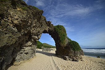 Nakabuang Arch in Morong Beach


References edit
- ^ Municipality of Sabtang | (DILG)
- ^ "2015 Census of Population, Report No. 3 – Population, Land Area, and Population Density" (PDF). Philippine Statistics Authority. Quezon City, Philippines. August 2016. ISSN 0117-1453. Archived (PDF) from the original on May 25, 2021. Retrieved July 16, 2021.
- ^ Error: Unable to display the reference properly. See the documentation for details.
- ^ a b c d Census of Population (2020). "Region II (Cagayan Valley)". Total Population by Province, City, Municipality and Barangay. Philippine Statistics Authority. Retrieved 8 July 2021.
- ^ "PSA Releases the 2018 Municipal and City Level Poverty Estimates". Philippine Statistics Authority. 15 December 2021. Retrieved 22 January 2022.
- ^ a b c d e González Alonzo, Fr. Julio, O.P. (1966). "The Batanes Islands", in Acta Manilana, Manila: University of Santo Tomas Research Center
- ^ "Province: Batanes". PSGC Interactive. Quezon City, Philippines: Philippine Statistics Authority. Retrieved 12 November 2016.
- ^ "Municipal: Sabtang". PSGC Interactive. Quezon City, Philippines: Philippine Statistics Authority. Retrieved 8 January 2016.
- ^ a b Census of Population and Housing (2010). "Region II (Cagayan Valley)" (PDF). Total Population by Province, City, Municipality and Barangay. National Statistics Office. Retrieved 29 June 2016.
- ^ "Sabtang, Batanes : Average Temperatures and Rainfall". Meteoblue. Retrieved 5 January 2019.
- ^ Census of Population (2015). "Region II (Cagayan Valley)". Total Population by Province, City, Municipality and Barangay. Philippine Statistics Authority. Retrieved 20 June 2016.
- ^ Censuses of Population (1903–2007). "Region II (Cagayan Valley)". Table 1. Population Enumerated in Various Censuses by Province/Highly Urbanized City: 1903 to 2007. National Statistics Office.
{{cite encyclopedia}}: CS1 maint: numeric names: authors list (link) - ^ "Province of Batanes". Municipality Population Data. Local Water Utilities Administration Research Division. Retrieved 17 December 2016.
- ^ "Poverty incidence (PI):". Philippine Statistics Authority. Retrieved December 28, 2020.
- ^ "Estimation of Local Poverty in the Philippines" (PDF). Philippine Statistics Authority. 29 November 2005.
- ^ "2003 City and Municipal Level Poverty Estimates" (PDF). Philippine Statistics Authority. 23 March 2009.
- ^ "City and Municipal Level Poverty Estimates; 2006 and 2009" (PDF). Philippine Statistics Authority. 3 August 2012.
- ^ "2012 Municipal and City Level Poverty Estimates" (PDF). Philippine Statistics Authority. 31 May 2016.
- ^ "Municipal and City Level Small Area Poverty Estimates; 2009, 2012 and 2015". Philippine Statistics Authority. 10 July 2019.
- ^ "PSA Releases the 2018 Municipal and City Level Poverty Estimates". Philippine Statistics Authority. 15 December 2021. Retrieved 22 January 2022.
- ^ "2029 National and Local Elections" (PDF). Commission on Elections. Retrieved March 6, 2022.
- ^ "DEPED REGIONAL OFFICE NO. 02". DepED RO2 | The official website of DepED Regional Office No. 02.
External links edit
- Philippine Standard Geographic Code