


Summary
Sacred Heart is a city in Renville County, Minnesota, United States. The population was 548 at the 2010 census.[4]
Sacred Heart | |
|---|---|
 | |
 Location of Sacred Heart, Minnesota | |
| Coordinates: 44°47′12″N 95°21′6″W / 44.78667°N 95.35167°W | |
| Country | United States |
| State | Minnesota |
| County | Renville |
| Area | |
| • Total | 0.99 sq mi (2.57 km2) |
| • Land | 0.99 sq mi (2.57 km2) |
| • Water | 0.00 sq mi (0.00 km2) |
| Elevation | 1,073 ft (327 m) |
| Population (2020) | |
| • Total | 510 |
| • Density | 514.11/sq mi (198.44/km2) |
| Time zone | UTC-6 (Central (CST)) |
| • Summer (DST) | UTC-5 (CDT) |
| ZIP code | 56285 |
| Area code | 320 |
| FIPS code | 27-56572[3] |
| GNIS feature ID | 0650451[2] |
History edit
Sacred Heart was the site of a massacre perpetrated by the Dakota early in the 1862 Dakota War. All but three of the white men in the area were killed, as were many of the white women and children. 22 whites were taken captive.[5]
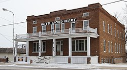
The town of Sacred Heart was platted in 1878.[6] The 1914 Hotel Sacred Heart is listed on the National Register of Historic Places.
Geography edit
According to the United States Census Bureau, the city has a total area of 0.99 square miles (2.56 km2), all land.[7] It is the westernmost town in Renville County.
U.S. Route 212 serves as a main route in the community.
Demographics edit
| Census | Pop. | Note | %± |
|---|---|---|---|
| 1880 | 76 | — | |
| 1890 | 327 | 330.3% | |
| 1900 | 538 | 64.5% | |
| 1910 | 587 | 9.1% | |
| 1920 | 763 | 30.0% | |
| 1930 | 685 | −10.2% | |
| 1940 | 752 | 9.8% | |
| 1950 | 745 | −0.9% | |
| 1960 | 696 | −6.6% | |
| 1970 | 707 | 1.6% | |
| 1980 | 666 | −5.8% | |
| 1990 | 603 | −9.5% | |
| 2000 | 549 | −9.0% | |
| 2010 | 548 | −0.2% | |
| 2020 | 510 | −6.9% | |
| U.S. Decennial Census[8] | |||
2010 census edit
As of the census[9] of 2010, there were 548 people, 235 households, and 139 families living in the city. The population density was 553.5 inhabitants per square mile (213.7/km2). There were 282 housing units at an average density of 284.8 per square mile (110.0/km2). The racial makeup of the city was 98.5% White, 0.2% African American, 0.9% Native American, and 0.4% from other races. Hispanic or Latino of any race were 9.1% of the population.
There were 235 households, of which 29.4% had children under the age of 18 living with them, 42.1% were married couples living together, 9.8% had a female householder with no husband present, 7.2% had a male householder with no wife present, and 40.9% were non-families. 35.7% of all households were made up of individuals, and 19.2% had someone living alone who was 65 years of age or older. The average household size was 2.33 and the average family size was 3.08.
The median age in the city was 36.6 years. 26.3% of residents were under the age of 18; 6.8% were between the ages of 18 and 24; 24.2% were from 25 to 44; 24.8% were from 45 to 64; and 17.9% were 65 years of age or older. The gender makeup of the city was 48.5% male and 51.5% female.
2000 census edit
As of the census[3] of 2000, there were 549 people, 246 households, and 147 families living in the city. The population density was 553.2 inhabitants per square mile (213.6/km2). There were 290 housing units at an average density of 292.2 per square mile (112.8/km2). The racial makeup of the city was 97.45% White, 0.18% Native American, 1.46% from other races, and 0.91% from two or more races. Hispanic or Latino of any race were 7.10% of the population.
There were 246 households, out of which 24.0% had children under the age of 18 living with them, 51.6% were married couples living together, 6.1% had a female householder with no husband present, and 40.2% were non-families. 36.6% of all households were made up of individuals, and 18.7% had someone living alone who was 65 years of age or older. The average household size was 2.23 and the average family size was 2.94.
In the city, the population was spread out, with 24.6% under the age of 18, 7.1% from 18 to 24, 23.0% from 25 to 44, 23.3% from 45 to 64, and 22.0% who were 65 years of age or older. The median age was 42 years. For every 100 females, there were 87.4 males. For every 100 females age 18 and over, there were 84.8 males.
The median income for a household in the city was $32,333, and the median income for a family was $40,313. Males had a median income of $28,654 versus $22,019 for females. The per capita income for the city was $18,089. About 5.4% of families and 10.9% of the population were below the poverty line, including 21.0% of those under age 18 and none of those age 65 or over.
Recreation edit
Sacred Heart has a state of the art baseball complex where the local Saints team plays baseball. Next door to the baseball field is an outdoor ice skating rink maintained in the winter months.
There is one primary park in town that has tennis courts available, along with a picnic pavilion, cooking grills and playgrounds for children.
Notable people edit
Noted people from Sacred Heart have included Ole Ramsland, a former member of the Minnesota House of Representatives,[10] and his son Max Ramsland, who later moved to Canada and was elected as a member of the Legislative Assembly of Saskatchewan. Alpha Sunde Smaby, a former member of the Minnesota House of Representatives was born in Sacred Heart.[11]
References edit
- ^ "2020 U.S. Gazetteer Files". United States Census Bureau. Retrieved July 24, 2022.
- ^ a b U.S. Geological Survey Geographic Names Information System: Sacred Heart, Minnesota
- ^ a b "U.S. Census website". United States Census Bureau. Retrieved January 31, 2008.
- ^ "2010 Census Redistricting Data (Public Law 94-171) Summary File". American FactFinder. United States Census Bureau. Retrieved April 27, 2011.[dead link]
- ^ Satterlee, M. P. (July 21, 1933). "The Massacre at Sacred Heart" (PDF). Minnesota Historical Society.
- ^ Upham, Warren (1920). Minnesota Geographic Names: Their Origin and Historic Significance. Minnesota Historical Society. p. 459.
- ^ "US Gazetteer files 2010". United States Census Bureau. Archived from the original on July 2, 2012. Retrieved November 13, 2012.
- ^ "Census of Population and Housing". Census.gov. Retrieved June 4, 2015.
- ^ "U.S. Census website". United States Census Bureau. Retrieved November 13, 2012.
- ^ Franklyn Curtiss-Wedge, History of Renville County Minnesota, Vol. 1. H. C. Cooper Jr, & Co., Chicago (1916).
- ^ Minnesota Legislators Past and Present-Alpha Sunde Smaby
External links edit
- http://www.sacredheartmn.org [Sacred Heart's Website]
44°47′13″N 95°21′06″W / 44.78694°N 95.35167°W