
KNOWPIA
WELCOME TO KNOWPIA

Saint-Crespin 
Summary
Saint-Crespin is a commune in the Seine-Maritime department in the Normandy region in north-western France.
Saint-Crespin | |
|---|---|
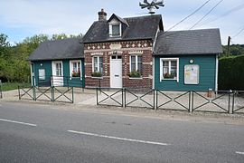 The town hall in Saint-Crespin | |
Location of Saint-Crespin .mw-parser-output .locmap .od{position:absolute}.mw-parser-output .locmap .id{position:absolute;line-height:0}.mw-parser-output .locmap .l0{font-size:0;position:absolute}.mw-parser-output .locmap .pv{line-height:110%;position:absolute;text-align:center}.mw-parser-output .locmap .pl{line-height:110%;position:absolute;top:-0.75em;text-align:right}.mw-parser-output .locmap .pr{line-height:110%;position:absolute;top:-0.75em;text-align:left}.mw-parser-output .locmap .pv>div{display:inline;padding:1px}.mw-parser-output .locmap .pl>div{display:inline;padding:1px;float:right}.mw-parser-output .locmap .pr>div{display:inline;padding:1px;float:left}html.skin-theme-clientpref-night .mw-parser-output .od,html.skin-theme-clientpref-night .mw-parser-output .od .pv>div,html.skin-theme-clientpref-night .mw-parser-output .od .pl>div,html.skin-theme-clientpref-night .mw-parser-output .od .pr>div{background:#000;color:#fff}html.skin-theme-clientpref-night .mw-parser-output .locmap{filter:grayscale(0.6)}@media(prefers-color-scheme:dark){html.skin-theme-clientpref-os .mw-parser-output .locmap{filter:grayscale(0.6)}html.skin-theme-clientpref-os .mw-parser-output .od,html.skin-theme-clientpref-os .mw-parser-output .od .pv>div,html.skin-theme-clientpref-os .mw-parser-output .od .pl>div,html.skin-theme-clientpref-os .mw-parser-output .od .pr>div{background:#000;color:#fff}}  Saint-Crespin  Saint-Crespin | |
| Coordinates: 49°47′01″N 1°06′44″E / 49.7836°N 1.1122°E | |
| Country | France |
| Region | Normandy |
| Department | Seine-Maritime |
| Arrondissement | Dieppe |
| Canton | Luneray |
| Intercommunality | CC Terroir de Caux |
| Government | |
| • Mayor (2020–2026) | Sophie Doré[1] |
| Area 1 | 6.35 km2 (2.45 sq mi) |
| Population (2021)[2] | 316 |
| • Density | 50/km2 (130/sq mi) |
| Time zone | UTC+01:00 (CET) |
| • Summer (DST) | UTC+02:00 (CEST) |
| INSEE/Postal code | 76570 /76590 |
| Elevation | 61–143 m (200–469 ft) (avg. 62 m or 203 ft) |
| 1 French Land Register data, which excludes lakes, ponds, glaciers > 1 km2 (0.386 sq mi or 247 acres) and river estuaries. | |
Geography edit
A farming village situated by the banks of the river Scie in the Pays de Caux, at the junction of the D3, D203 and the D149 roads, some 10 miles (16 km) south of Dieppe.
Population edit
| Year | Pop. | ±% p.a. |
|---|---|---|
| 1968 | 174 | — |
| 1975 | 177 | +0.24% |
| 1982 | 263 | +5.82% |
| 1990 | 283 | +0.92% |
| 1999 | 284 | +0.04% |
| 2007 | 282 | −0.09% |
| 2012 | 288 | +0.42% |
| 2017 | 295 | +0.48% |
| Source: INSEE[3] | ||
Places of interest edit
- The church, dating from the thirteenth century.
- The château de Longueville.
See also edit
References edit
- ^ "Répertoire national des élus: les maires". data.gouv.fr, Plateforme ouverte des données publiques françaises (in French). 2 December 2020.
- ^ "Populations légales 2021". The National Institute of Statistics and Economic Studies. 28 December 2023.
- ^ Population en historique depuis 1968, INSEE
Wikimedia Commons has media related to Saint-Crespin (Seine-Maritime).