
KNOWPIA
WELCOME TO KNOWPIA

Saint-Hilaire-sur-Puiseaux 
Summary
Saint-Hilaire-sur-Puiseaux (French pronunciation: [sɛ̃.t‿ilɛʁ syʁ pɥizo], literally Saint-Hilaire on Puiseaux) is a commune in the Loiret department in north-central France.
Saint-Hilaire-sur-Puiseaux | |
|---|---|
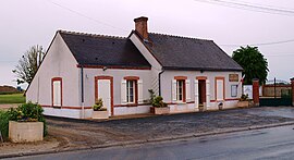 The town hall in Saint-Hilaire-sur-Puiseaux | |
Location of Saint-Hilaire-sur-Puiseaux .mw-parser-output .locmap .od{position:absolute}.mw-parser-output .locmap .id{position:absolute;line-height:0}.mw-parser-output .locmap .l0{font-size:0;position:absolute}.mw-parser-output .locmap .pv{line-height:110%;position:absolute;text-align:center}.mw-parser-output .locmap .pl{line-height:110%;position:absolute;top:-0.75em;text-align:right}.mw-parser-output .locmap .pr{line-height:110%;position:absolute;top:-0.75em;text-align:left}.mw-parser-output .locmap .pv>div{display:inline;padding:1px}.mw-parser-output .locmap .pl>div{display:inline;padding:1px;float:right}.mw-parser-output .locmap .pr>div{display:inline;padding:1px;float:left}html.skin-theme-clientpref-night .mw-parser-output .od,html.skin-theme-clientpref-night .mw-parser-output .od .pv>div,html.skin-theme-clientpref-night .mw-parser-output .od .pl>div,html.skin-theme-clientpref-night .mw-parser-output .od .pr>div{background:#000;color:#fff}html.skin-theme-clientpref-night .mw-parser-output .locmap{filter:grayscale(0.6)}@media(prefers-color-scheme:dark){html.skin-theme-clientpref-os .mw-parser-output .locmap{filter:grayscale(0.6)}html.skin-theme-clientpref-os .mw-parser-output .od,html.skin-theme-clientpref-os .mw-parser-output .od .pv>div,html.skin-theme-clientpref-os .mw-parser-output .od .pl>div,html.skin-theme-clientpref-os .mw-parser-output .od .pr>div{background:#000;color:#fff}}  Saint-Hilaire-sur-Puiseaux  Saint-Hilaire-sur-Puiseaux | |
| Coordinates: 47°54′05″N 2°42′20″E / 47.9014°N 2.7056°E | |
| Country | France |
| Region | Centre-Val de Loire |
| Department | Loiret |
| Arrondissement | Montargis |
| Canton | Lorris |
| Intercommunality | Canaux et Forêts en Gâtinais |
| Government | |
| • Mayor (2020–2026) | Patrice Vieugué[1] |
| Area 1 | 11.34 km2 (4.38 sq mi) |
| Population (2021)[2] | 158 |
| • Density | 14/km2 (36/sq mi) |
| Time zone | UTC+01:00 (CET) |
| • Summer (DST) | UTC+02:00 (CEST) |
| INSEE/Postal code | 45283 /45700 |
| Elevation | 96–110 m (315–361 ft) |
| 1 French Land Register data, which excludes lakes, ponds, glaciers > 1 km2 (0.386 sq mi or 247 acres) and river estuaries. | |
It is located about 60 km east of Orléans, on the Puiseaux river. Its neighbouring communes include Ouzouer-des-Champs, Solterre, Oussoy-en-Gâtinais, Varennes-Changy and Montcresson.
The village has a small chateau, on a square plan with corner turrets.
See also edit
References edit
- ^ "Répertoire national des élus: les maires" (in French). data.gouv.fr, Plateforme ouverte des données publiques françaises. 4 May 2022.
- ^ "Populations légales 2021". The National Institute of Statistics and Economic Studies. 28 December 2023.
Wikimedia Commons has media related to Saint-Hilaire-sur-Puiseaux.