
KNOWPIA
WELCOME TO KNOWPIA

Saint-Jean-de-la-Ruelle 
Summary
Saint-Jean-de-la-Ruelle (pronounced [sɛ̃ ʒɑ̃ d(ə) la ʁɥɛl]) is a commune in the Loiret department in the administrative region of Centre-Val de Loire, France.
Saint-Jean-de-la-Ruelle | |
|---|---|
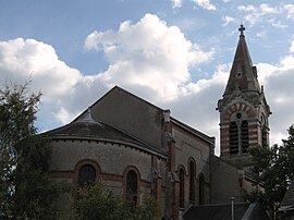 The church in Saint-Jean-de-la-Ruelle | |
 Coat of arms | |
Location of Saint-Jean-de-la-Ruelle .mw-parser-output .locmap .od{position:absolute}.mw-parser-output .locmap .id{position:absolute;line-height:0}.mw-parser-output .locmap .l0{font-size:0;position:absolute}.mw-parser-output .locmap .pv{line-height:110%;position:absolute;text-align:center}.mw-parser-output .locmap .pl{line-height:110%;position:absolute;top:-0.75em;text-align:right}.mw-parser-output .locmap .pr{line-height:110%;position:absolute;top:-0.75em;text-align:left}.mw-parser-output .locmap .pv>div{display:inline;padding:1px}.mw-parser-output .locmap .pl>div{display:inline;padding:1px;float:right}.mw-parser-output .locmap .pr>div{display:inline;padding:1px;float:left}html.skin-theme-clientpref-night .mw-parser-output .od,html.skin-theme-clientpref-night .mw-parser-output .od .pv>div,html.skin-theme-clientpref-night .mw-parser-output .od .pl>div,html.skin-theme-clientpref-night .mw-parser-output .od .pr>div{background:#000;color:#fff}html.skin-theme-clientpref-night .mw-parser-output .locmap{filter:grayscale(0.6)}@media(prefers-color-scheme:dark){html.skin-theme-clientpref-os .mw-parser-output .locmap{filter:grayscale(0.6)}html.skin-theme-clientpref-os .mw-parser-output .od,html.skin-theme-clientpref-os .mw-parser-output .od .pv>div,html.skin-theme-clientpref-os .mw-parser-output .od .pl>div,html.skin-theme-clientpref-os .mw-parser-output .od .pr>div{background:#000;color:#fff}}  Saint-Jean-de-la-Ruelle  Saint-Jean-de-la-Ruelle | |
| Coordinates: 47°54′50″N 1°52′28″E / 47.9139°N 1.8745°E | |
| Country | France |
| Region | Centre-Val de Loire |
| Department | Loiret |
| Arrondissement | Orléans |
| Canton | Saint-Jean-de-la-Ruelle |
| Intercommunality | Orléans Métropole |
| Government | |
| • Mayor (2023–2026) | Fabien Rivière-Da-Silva[1] |
| Area 1 | 6.06 km2 (2.34 sq mi) |
| Population (2021)[2] | 16,594 |
| • Density | 2,700/km2 (7,100/sq mi) |
| Time zone | UTC+01:00 (CET) |
| • Summer (DST) | UTC+02:00 (CEST) |
| INSEE/Postal code | 45285 /45140 |
| Elevation | 90–121 m (295–397 ft) |
| 1 French Land Register data, which excludes lakes, ponds, glaciers > 1 km2 (0.386 sq mi or 247 acres) and river estuaries. | |
It is located about 3.5 km (2.2 mi) from Orléans.
Populations edit
| Year | Pop. | ±% p.a. |
|---|---|---|
| 1968 | 12,620 | — |
| 1975 | 16,359 | +3.78% |
| 1982 | 17,062 | +0.60% |
| 1990 | 16,335 | −0.54% |
| 1999 | 16,560 | +0.15% |
| 2007 | 16,406 | −0.12% |
| 2012 | 16,833 | +0.52% |
| 2017 | 16,273 | −0.67% |
| Source: INSEE[3] | ||
Personalities edit
- Dosseh, rapper and actor
- Stéphane Kakou, footballer
Twin towns – sister cities edit
Saint-Jean-de-la-Ruelle is twinned with:[4]
 Amposta, Spain
 Gommern, Germany
 Niepołomice, Poland
See also edit
References edit
- ^ "Répertoire national des élus: les maires" (in French). data.gouv.fr, Plateforme ouverte des données publiques françaises. 30 November 2023.
- ^ "Populations légales 2021". The National Institute of Statistics and Economic Studies. 28 December 2023.
- ^ Population en historique depuis 1968, INSEE
- ^ "Jumelage – villes amies" (in French). Saint-Jean-de-la-Ruelle. Retrieved 5 April 2022.
Wikimedia Commons has media related to Saint-Jean-de-la-Ruelle.