
KNOWPIA
WELCOME TO KNOWPIA

Saint-Malon-sur-Mel 
Summary
Saint-Malon-sur-Mel (French pronunciation: [sɛ̃ malɔ̃ syʁ mɛl]; Breton: Sant-Malon; Gallo: Saent-Méha) is a commune in the Ille-et-Vilaine department of Brittany in northwestern France.
Saint-Malon-sur-Mel
| |
|---|---|
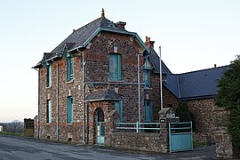 The town hall of Saint-Malon-sur-Mel | |
 Coat of arms | |
Location of Saint-Malon-sur-Mel .mw-parser-output .locmap .od{position:absolute}.mw-parser-output .locmap .id{position:absolute;line-height:0}.mw-parser-output .locmap .l0{font-size:0;position:absolute}.mw-parser-output .locmap .pv{line-height:110%;position:absolute;text-align:center}.mw-parser-output .locmap .pl{line-height:110%;position:absolute;top:-0.75em;text-align:right}.mw-parser-output .locmap .pr{line-height:110%;position:absolute;top:-0.75em;text-align:left}.mw-parser-output .locmap .pv>div{display:inline;padding:1px}.mw-parser-output .locmap .pl>div{display:inline;padding:1px;float:right}.mw-parser-output .locmap .pr>div{display:inline;padding:1px;float:left}html.skin-theme-clientpref-night .mw-parser-output .od,html.skin-theme-clientpref-night .mw-parser-output .od .pv>div,html.skin-theme-clientpref-night .mw-parser-output .od .pl>div,html.skin-theme-clientpref-night .mw-parser-output .od .pr>div{background:#000;color:#fff}html.skin-theme-clientpref-night .mw-parser-output .locmap{filter:grayscale(0.6)}@media(prefers-color-scheme:dark){html.skin-theme-clientpref-os .mw-parser-output .locmap{filter:grayscale(0.6)}html.skin-theme-clientpref-os .mw-parser-output .od,html.skin-theme-clientpref-os .mw-parser-output .od .pv>div,html.skin-theme-clientpref-os .mw-parser-output .od .pl>div,html.skin-theme-clientpref-os .mw-parser-output .od .pr>div{background:#000;color:#fff}}  Saint-Malon-sur-Mel  Saint-Malon-sur-Mel | |
| Coordinates: 48°05′38″N 2°05′51″W / 48.0939°N 2.0975°W | |
| Country | France |
| Region | Brittany |
| Department | Ille-et-Vilaine |
| Arrondissement | Rennes |
| Canton | Montauban-de-Bretagne |
| Government | |
| • Mayor (2020–2026) | Gilles Le Métayer[1] |
| Area 1 | 16.07 km2 (6.20 sq mi) |
| Population (2021)[2] | 601 |
| • Density | 37/km2 (97/sq mi) |
| Time zone | UTC+01:00 (CET) |
| • Summer (DST) | UTC+02:00 (CEST) |
| INSEE/Postal code | 35290 /35750 |
| Elevation | 46–116 m (151–381 ft) |
| 1 French Land Register data, which excludes lakes, ponds, glaciers > 1 km2 (0.386 sq mi or 247 acres) and river estuaries. | |
Population edit
Inhabitants of Saint-Malon-sur-Mel are called malonnais in French.
| Year | Pop. | ±% |
|---|---|---|
| 1962 | 464 | — |
| 1968 | 554 | +19.4% |
| 1975 | 492 | −11.2% |
| 1982 | 449 | −8.7% |
| 1990 | 447 | −0.4% |
| 1999 | 447 | +0.0% |
| 2009 | 582 | +30.2% |
See also edit
References edit
- ^ "Répertoire national des élus: les maires". data.gouv.fr, Plateforme ouverte des données publiques françaises (in French). 2 December 2020.
- ^ "Populations légales 2021". The National Institute of Statistics and Economic Studies. 28 December 2023.
External links edit
Wikimedia Commons has media related to Saint-Malon-sur-Mel.
- Mayors of Ille-et-Vilaine Association (in French)