


Summary
Saint-Nicolas-de-Macherin (French pronunciation: [sɛ̃ nikɔla də maʃʁɛ̃]) is a commune in the Isère department within Auvergne-Rhône-Alpes in southeastern France.[3] The area of the commune is 1,060 hectares and the altitude lies between 447 and 952 meters.
Saint-Nicolas-de-Macherin | |
|---|---|
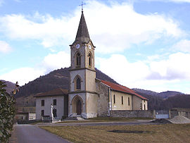 The church of Saint-Nicolas-de-Macherin | |
Location of Saint-Nicolas-de-Macherin .mw-parser-output .locmap .od{position:absolute}.mw-parser-output .locmap .id{position:absolute;line-height:0}.mw-parser-output .locmap .l0{font-size:0;position:absolute}.mw-parser-output .locmap .pv{line-height:110%;position:absolute;text-align:center}.mw-parser-output .locmap .pl{line-height:110%;position:absolute;top:-0.75em;text-align:right}.mw-parser-output .locmap .pr{line-height:110%;position:absolute;top:-0.75em;text-align:left}.mw-parser-output .locmap .pv>div{display:inline;padding:1px}.mw-parser-output .locmap .pl>div{display:inline;padding:1px;float:right}.mw-parser-output .locmap .pr>div{display:inline;padding:1px;float:left}html.skin-theme-clientpref-night .mw-parser-output .od,html.skin-theme-clientpref-night .mw-parser-output .od .pv>div,html.skin-theme-clientpref-night .mw-parser-output .od .pl>div,html.skin-theme-clientpref-night .mw-parser-output .od .pr>div{background:#000;color:#fff}html.skin-theme-clientpref-night .mw-parser-output .locmap{filter:grayscale(0.6)}@media(prefers-color-scheme:dark){html.skin-theme-clientpref-os .mw-parser-output .locmap{filter:grayscale(0.6)}html.skin-theme-clientpref-os .mw-parser-output .od,html.skin-theme-clientpref-os .mw-parser-output .od .pv>div,html.skin-theme-clientpref-os .mw-parser-output .od .pl>div,html.skin-theme-clientpref-os .mw-parser-output .od .pr>div{background:#000;color:#fff}}  Saint-Nicolas-de-Macherin  Saint-Nicolas-de-Macherin | |
| Coordinates: 45°23′57″N 5°36′27″E / 45.3992°N 5.6075°E | |
| Country | France |
| Region | Auvergne-Rhône-Alpes |
| Department | Isère |
| Arrondissement | Grenoble |
| Canton | Voiron |
| Intercommunality | CA Pays Voironnais |
| Government | |
| • Mayor (2020–2026) | Freddy Rey[1] |
| Area 1 | 10.6 km2 (4.1 sq mi) |
| Population (2021)[2] | 955 |
| • Density | 90/km2 (230/sq mi) |
| Time zone | UTC+01:00 (CET) |
| • Summer (DST) | UTC+02:00 (CEST) |
| INSEE/Postal code | 38432 /38500 |
| Elevation | 447–952 m (1,467–3,123 ft) (avg. 420 m or 1,380 ft) |
| 1 French Land Register data, which excludes lakes, ponds, glaciers > 1 km2 (0.386 sq mi or 247 acres) and river estuaries. | |
The town is located 5 km from Voiron, which is the seat of the canton. It is 28 km north-west of Grenoble, 90 km from Lyon, and 510 km from Paris.
Population edit
|
| ||||||||||||||||||||||||||||||||||||||||||||||||||||||
| Source: EHESS[4] and INSEE (1968-2020)[5] | |||||||||||||||||||||||||||||||||||||||||||||||||||||||
In 2020, the commune had 966 inhabitants, an 8.8% increase since 2009.[5]
Housing edit
As of 2020, 89.6% of households live in single-family houses, compared to 10.4% in apartments. 93.5% of housing are main residences, 2.2% are second homes and the rest being vacant. 19% of housing was built before 1919, while 55% was built between 1971 and 2005.[6]
Places of interest edit
- Château de Hautefort - the oldest building in the town, now divided into apartments.
- Pied Barlet - ruins of the ancient fortress from the 13th century.[7][8]
- Chapel of Hautefort castle [7]
- Church of Saint Nicolas, rebuilt between 1885 and 1889, designed by architect Jean-Francois Pichat.[9]
Economy edit
In 2020, 4.3% of the active population was unemployed.[10] This is low in comparison to the department unemployment rate of 10.4% for the same period.
The SITPM (Société Industrielle des Tissages Paul Merle) employs 58 people and manufactures fabrics. This factory was created in 1853 under the name of Usine de Tissage de Sainte-Marie d'Hautefort. The site covers 15,000m² and has more than 130 automated looms.
The town is part of the geographical area of production and transformation of Bois de Chartreuse, the first AOC of the wood sector in France.[11][12]
Administration edit
| Period | Identity | Label | Quality | |
|---|---|---|---|---|
| 2020 | Current | Freddy Rey | ||
| 2001 | 2020 | Roland Grambin | None | |
| 1989 | 2001 | Marcel Descombes | None | |
| 1965 | 1989 | Jean Tabeling | None | |
| 1945 | Paul Merle | |||
| 1944 | 1945 | Jean Marcoz | (Provisional municipal council) | |
| 1943 | 1944 | Joseph Gaillard | (Deputy mayor following the resignation of Louis Fauchon) | |
| 1925 | 1943 | Louis Fauchon | ||
| 1925 | Liguori Vial | |||
| 1892 | Remy Fagot | |||
| 1883 | 1892 | Francois Guilligay | ||
| 1868 | 1883 | Antoine Fagot-Mallot | ||
| 1863 | 1868 | Joseph Vial | ||
| 1811 | 1813 | Jean Tivollier | ||
| 1807 | 1811 | Jean Vial | ||
Notable people edit
- Paul Picard - deputy for Isère, born and died in the town.
- Amédée de Foras - politician and diplomat, married and lived in the town at the Château de Hautefort.
- Family of Mourand de Jouffrey - descendants of Jean-Antione Morand de Jouffrey, who worked in Lyon (1727-1794) and created the 6th arrondissement (Brotteaux). A bridge, as well as a car park, still bear his name. His son, Antoine Morand de Jouffrey, was appointed the attorney general of the king at the Lyon finance office in 1785.
See also edit
References edit
- ^ "Répertoire national des élus: les maires" (in French). data.gouv.fr, Plateforme ouverte des données publiques françaises. 13 September 2022.
- ^ "Populations légales 2021". The National Institute of Statistics and Economic Studies. 28 December 2023.
- ^ INSEE commune file
- ^ Des villages de Cassini aux communes d'aujourd'hui: Commune data sheet Saint-Nicolas-de-Macherin, EHESS (in French).
- ^ a b Population en historique depuis 1968, INSEE
- ^ Logement en 2020,INSEE
- ^ a b Tasset, Eric (2005). Châteaux forts de l'Isère : Grenoble et le Nord de son arrondissement. Grenoble: éditions de Belledonne. pp. 498–501. ISBN 2911148665.
- ^ Bourrillon, Corinne (2016). 10,000 lieux en Pays Voironnais. Chirens: Coordonnet. pp. 188–191.
- ^ Cayol-Gerin, Anne (2017). Le Pays Voironnais - Patrimoine en Isère. Editions Conseil Départemental de l'Isère. p. 41.
- ^ "Population active, emploi et chômage au sens du recensement en 2020". INSEE.
- ^ "Official site of Bois de Chartreuse" (PDF).
- ^ "Official Bulletin of the Ministry of Agriculture and Food, No. 2018-46". info.agriculture.gouv.fr.