
KNOWPIA
WELCOME TO KNOWPIA

Saint-Plancard 
Summary
Saint-Plancard (French pronunciation: [sɛ̃ plɑ̃kaʁ]; Gascon: Sent Blancat) is a commune in the Haute-Garonne department in southwestern France.
Saint-Plancard | |
|---|---|
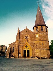 The church of Saint Pancrace, Saint-Plancard | |
 Coat of arms | |
Location of Saint-Plancard .mw-parser-output .locmap .od{position:absolute}.mw-parser-output .locmap .id{position:absolute;line-height:0}.mw-parser-output .locmap .l0{font-size:0;position:absolute}.mw-parser-output .locmap .pv{line-height:110%;position:absolute;text-align:center}.mw-parser-output .locmap .pl{line-height:110%;position:absolute;top:-0.75em;text-align:right}.mw-parser-output .locmap .pr{line-height:110%;position:absolute;top:-0.75em;text-align:left}.mw-parser-output .locmap .pv>div{display:inline;padding:1px}.mw-parser-output .locmap .pl>div{display:inline;padding:1px;float:right}.mw-parser-output .locmap .pr>div{display:inline;padding:1px;float:left}html.skin-theme-clientpref-night .mw-parser-output .od,html.skin-theme-clientpref-night .mw-parser-output .od .pv>div,html.skin-theme-clientpref-night .mw-parser-output .od .pl>div,html.skin-theme-clientpref-night .mw-parser-output .od .pr>div{background:#fff;color:#000}html.skin-theme-clientpref-night .mw-parser-output .locmap{filter:grayscale(0.6)}@media(prefers-color-scheme:dark){html.skin-theme-clientpref-os .mw-parser-output .locmap{filter:grayscale(0.6)}html.skin-theme-clientpref-os .mw-parser-output .od,html.skin-theme-clientpref-os .mw-parser-output .od .pv>div,html.skin-theme-clientpref-os .mw-parser-output .od .pl>div,html.skin-theme-clientpref-os .mw-parser-output .od .pr>div{background:white;color:#000}}  Saint-Plancard  Saint-Plancard | |
| Coordinates: 43°10′16″N 0°34′30″E / 43.1711°N 0.575°E | |
| Country | France |
| Region | Occitania |
| Department | Haute-Garonne |
| Arrondissement | Saint-Gaudens |
| Canton | Saint-Gaudens |
| Intercommunality | CC Cœur et Coteaux du Comminges |
| Government | |
| • Mayor (2020–2026) | Marie-Hélène Fontaneau[1] |
| Area 1 | 16.09 km2 (6.21 sq mi) |
| Population (2021)[2] | 394 |
| • Density | 24/km2 (63/sq mi) |
| Time zone | UTC+01:00 (CET) |
| • Summer (DST) | UTC+02:00 (CEST) |
| INSEE/Postal code | 31513 /31580 |
| Elevation | 349–530 m (1,145–1,739 ft) (avg. 370 m or 1,210 ft) |
| Website | https://saintplancard.com |
| 1 French Land Register data, which excludes lakes, ponds, glaciers > 1 km2 (0.386 sq mi or 247 acres) and river estuaries. | |

Population edit
In 2019, the commune had a population of 392.[3] As of 2019, there are 268 dwellings in the commune, of which 198 primary residences.[4]
| Year | Pop. | ±% |
|---|---|---|
| 1962 | 385 | — |
| 1968 | 475 | +23.4% |
| 1975 | 401 | −15.6% |
| 1982 | 476 | +18.7% |
| 1990 | 452 | −5.0% |
| 1999 | 372 | −17.7% |
| 2008 | 383 | +3.0% |
| 2019 | 392 | +2.3% |
See also edit
References edit
- ^ "Répertoire national des élus: les maires". data.gouv.fr, Plateforme ouverte des données publiques françaises (in French). 2 December 2020.
- ^ "Populations légales 2021". The National Institute of Statistics and Economic Studies. 28 December 2023.
- ^ Populations légales 2019: 31 Haute-Garonne, INSEE
- ^ Logement en 2019, Commune de Saint-Plancard (31513), INSEE
Wikimedia Commons has media related to Saint-Plancard.