


Summary
Saint Augustin (also known as Ianantsony; Malagasy: Anantsono) is a rural municipality in Madagascar. It belongs to the district of Toliara II, which is a part of Atsimo-Andrefana Region. The population of the commune was estimated to be approximately 15,000 in 2001 commune census.[2] The mouth of the Onilahy River is near the town.
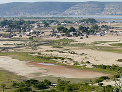
Saint Augustin
Ianantsony | |
|---|---|
 Saint Augustin | |
 Saint Augustin Location in Madagascar | |
| Coordinates: 23°33′S 43°46′E / 23.550°S 43.767°E | |
| Country | |
| Province | Toliara |
| Region | Atsimo-Andrefana |
| District | Toliara II |
| Elevation | 39 m (128 ft) |
| Population (2001)[2] | |
| • Total | 15,000 |
| Time zone | UTC3 (EAT) |
| Postal code | 602 |
Primary and junior level secondary education are available in town. The majority 60% of the population works in fishing. 23% are farmers, while an additional 10% receives their livelihood from raising livestock. The most important crops are sweet potatoes and rice; also lima beans is an important agricultural product. Services provide employment for 7% of the population.[2]
England's Courteen association attempted to sponsor a colony nearby in 1645 but by 1646 famine, disease, and conflict with the Malagasy drove the English settlers away and the colony failed.[3] Pirates such as John Pro, Thomas White, Samuel Burgess, and John Halsey frequented the area in the early 18th century. Ex-pirate John Rivers established a pirate settlement at Saint Augustin, resupplying passing ships for a fee and trading in slaves; his trading post lasted from 1686 until his death in 1719.[4]
Geography edit
It is situated south of Toliara (Tuléar) at the mouth of the Onilahy River to the Bay of Saint-Augustin and the Indian Ocean. There used to be a ferry over the Onilahy to Soalara but it broke down.[5] It is necessary to take small outrigger canoes or to make the trip around the bay (250 km) since 2021.
References edit
- ^ Estimated based on DEM data from Shuttle Radar Topography Mission
- ^ a b c "ILO census data". Cornell University. 2002. Retrieved 2008-03-13.
- ^ Bradt, Hilary; Austin, Daniel (2014). Madagascar. Guilford CT: Bradt Travel Guides. p. 216. ISBN 9781841624983. Retrieved 27 July 2018.
- ^ Grey, Charles (1933). Pirates of the eastern seas (1618-1723): a lurid page of history. London: S. Low, Marston & co., ltd. Retrieved 26 June 2017.
- ^ Bac Fiavota abandonné.
23°33′S 43°46′E / 23.550°S 43.767°E