
KNOWPIA
WELCOME TO KNOWPIA

Sainte-Austreberthe, Seine-Maritime 
Summary
Sainte-Austreberthe is a commune in the Seine-Maritime department in the Normandy region in northern France.
Sainte-Austreberthe | |
|---|---|
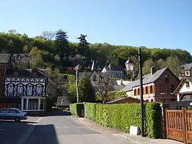 A view within Sainte-Austreberthe | |
 Coat of arms | |
Location of Sainte-Austreberthe .mw-parser-output .locmap .od{position:absolute}.mw-parser-output .locmap .id{position:absolute;line-height:0}.mw-parser-output .locmap .l0{font-size:0;position:absolute}.mw-parser-output .locmap .pv{line-height:110%;position:absolute;text-align:center}.mw-parser-output .locmap .pl{line-height:110%;position:absolute;top:-0.75em;text-align:right}.mw-parser-output .locmap .pr{line-height:110%;position:absolute;top:-0.75em;text-align:left}.mw-parser-output .locmap .pv>div{display:inline;padding:1px}.mw-parser-output .locmap .pl>div{display:inline;padding:1px;float:right}.mw-parser-output .locmap .pr>div{display:inline;padding:1px;float:left}html.skin-theme-clientpref-night .mw-parser-output .od,html.skin-theme-clientpref-night .mw-parser-output .od .pv>div,html.skin-theme-clientpref-night .mw-parser-output .od .pl>div,html.skin-theme-clientpref-night .mw-parser-output .od .pr>div{background:#000;color:#fff}html.skin-theme-clientpref-night .mw-parser-output .locmap{filter:grayscale(0.6)}@media(prefers-color-scheme:dark){html.skin-theme-clientpref-os .mw-parser-output .locmap{filter:grayscale(0.6)}html.skin-theme-clientpref-os .mw-parser-output .od,html.skin-theme-clientpref-os .mw-parser-output .od .pv>div,html.skin-theme-clientpref-os .mw-parser-output .od .pl>div,html.skin-theme-clientpref-os .mw-parser-output .od .pr>div{background:#000;color:#fff}}  Sainte-Austreberthe  Sainte-Austreberthe | |
| Coordinates: 49°35′55″N 0°58′31″E / 49.5986°N 0.9753°E | |
| Country | France |
| Region | Normandy |
| Department | Seine-Maritime |
| Arrondissement | Rouen |
| Canton | Notre-Dame-de-Bondeville |
| Government | |
| • Mayor (2020–2026) | Daniel Gressent[1] |
| Area 1 | 6.13 km2 (2.37 sq mi) |
| Population (2021)[2] | 665 |
| • Density | 110/km2 (280/sq mi) |
| Time zone | UTC+01:00 (CET) |
| • Summer (DST) | UTC+02:00 (CEST) |
| INSEE/Postal code | 76566 /76570 |
| Elevation | 77–168 m (253–551 ft) (avg. 85 m or 279 ft) |
| 1 French Land Register data, which excludes lakes, ponds, glaciers > 1 km2 (0.386 sq mi or 247 acres) and river estuaries. | |
Geography edit
A village of farming and forestry situated by the banks of the river Austreberthe, some 14 miles (23 km) northwest of Rouen at the junction of the D22, D53 and the D103 roads.
Heraldry edit
 |
The arms of Sainte-Austreberthe are blazoned : Or, St. Austreberthe argent vested proper, holding a crozier sable in her left hand, a wolf ??? overlying her feet, and on a chief vert a fess wavy argent.
|
Population edit
| Year | Pop. | ±% p.a. |
|---|---|---|
| 1968 | 416 | — |
| 1975 | 545 | +3.93% |
| 1982 | 453 | −2.61% |
| 1990 | 521 | +1.76% |
| 1999 | 583 | +1.26% |
| 2007 | 586 | +0.06% |
| 2012 | 611 | +0.84% |
| 2017 | 612 | +0.03% |
| Source: INSEE[3] | ||
Places of interest edit
- The church of St. Austreberthe, dating from the eleventh century.
- The chateau of Langrume.
- The sixteenth-century stone cross in the cemetery.
See also edit
References edit
- ^ Liste des maires du département de la Seine-Maritime, 10 August 2020
- ^ "Populations légales 2021". The National Institute of Statistics and Economic Studies. 28 December 2023.
- ^ Population en historique depuis 1968, INSEE
Wikimedia Commons has media related to Sainte-Austreberthe, Seine-Maritime.