
KNOWPIA
WELCOME TO KNOWPIA

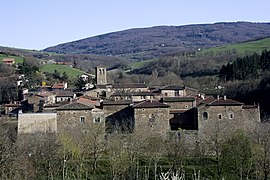
Sainte-Croix-en-Jarez 
Summary
Sainte-Croix-en-Jarez (French pronunciation: [sɛ̃t kʁwa ɑ̃ ʒaʁɛ]) is a commune in the Loire department in central France.[3]
Sainte-Croix-en-Jarez | |
|---|---|
Commune | |
 Priory | |
 Coat of arms | |
Location of Sainte-Croix-en-Jarez .mw-parser-output .locmap .od{position:absolute}.mw-parser-output .locmap .id{position:absolute;line-height:0}.mw-parser-output .locmap .l0{font-size:0;position:absolute}.mw-parser-output .locmap .pv{line-height:110%;position:absolute;text-align:center}.mw-parser-output .locmap .pl{line-height:110%;position:absolute;top:-0.75em;text-align:right}.mw-parser-output .locmap .pr{line-height:110%;position:absolute;top:-0.75em;text-align:left}.mw-parser-output .locmap .pv>div{display:inline;padding:1px}.mw-parser-output .locmap .pl>div{display:inline;padding:1px;float:right}.mw-parser-output .locmap .pr>div{display:inline;padding:1px;float:left}html.skin-theme-clientpref-night .mw-parser-output .od,html.skin-theme-clientpref-night .mw-parser-output .od .pv>div,html.skin-theme-clientpref-night .mw-parser-output .od .pl>div,html.skin-theme-clientpref-night .mw-parser-output .od .pr>div{background:#000;color:#fff}html.skin-theme-clientpref-night .mw-parser-output .locmap{filter:grayscale(0.6)}@media(prefers-color-scheme:dark){html.skin-theme-clientpref-os .mw-parser-output .locmap{filter:grayscale(0.6)}html.skin-theme-clientpref-os .mw-parser-output .od,html.skin-theme-clientpref-os .mw-parser-output .od .pv>div,html.skin-theme-clientpref-os .mw-parser-output .od .pl>div,html.skin-theme-clientpref-os .mw-parser-output .od .pr>div{background:#000;color:#fff}}  Sainte-Croix-en-Jarez  Sainte-Croix-en-Jarez | |
| Coordinates: 45°28′49″N 4°38′52″E / 45.4803°N 04.6478°E | |
| Country | France |
| Region | Auvergne-Rhône-Alpes |
| Department | Loire |
| Arrondissement | Saint-Étienne |
| Canton | Le Pilat |
| Intercommunality | Saint-Étienne Métropole |
| Government | |
| • Mayor (2020–2026) | Daniel Torgues[1] |
| Area 1 | 12 km2 (5 sq mi) |
| Population (2021)[2] | 484 |
| • Density | 40/km2 (100/sq mi) |
| Time zone | UTC+01:00 (CET) |
| • Summer (DST) | UTC+02:00 (CEST) |
| INSEE/Postal code | 42210 /42800 |
| Elevation | 349–955 m (1,145–3,133 ft) |
| 1 French Land Register data, which excludes lakes, ponds, glaciers > 1 km2 (0.386 sq mi or 247 acres) and river estuaries. | |
Population edit
| Year | Pop. | ±% p.a. |
|---|---|---|
| 1968 | 274 | — |
| 1975 | 310 | +1.78% |
| 1982 | 342 | +1.41% |
| 1990 | 329 | −0.48% |
| 1999 | 351 | +0.72% |
| 2009 | 430 | +2.05% |
| 2014 | 449 | +0.87% |
| 2020 | 477 | +1.01% |
| Source: INSEE[4] | ||
See also edit
References edit
- ^ "Répertoire national des élus: les maires". data.gouv.fr, Plateforme ouverte des données publiques françaises (in French). 2 December 2020.
- ^ "Populations légales 2021". The National Institute of Statistics and Economic Studies. 28 December 2023.
- ^ INSEE commune file
- ^ Population en historique depuis 1968, INSEE
External links edit
- Official Web site
Wikimedia Commons has media related to Sainte-Croix-en-Jarez.