


Summary
Sakaide (坂出市, Sakaide-shi) is a city located in Kagawa Prefecture, Japan. As of 1 October 2022[update], the city had an estimated population of 49,439 in 21347 households and a population density of and a population density of 530 persons per km2.[1] The total area of the city is 92.49 square kilometres (35.71 sq mi).
Sakaide
坂出市 | |
|---|---|
  Upper stage: Great Seto Bridge Lower stage: Skyline of Sakaide city | |
 Flag  Seal | |
Location of Sakaide in Kagawa Prefecture | |
 Sakaide Location in Japan | |
| Coordinates: 34°19′N 133°52′E / 34.317°N 133.867°E | |
| Country | Japan |
| Region | Shikoku |
| Prefecture | Kagawa |
| Government | |
| • Mayor | Tetsuji Arifuku |
| Area | |
| • Total | 92.49 km2 (35.71 sq mi) |
| Population (October 1, 2022) | |
| • Total | 49,439 |
| • Density | 530/km2 (1,400/sq mi) |
| Time zone | UTC+09:00 (JST) |
| City hall address | 2-3-5, Muromachi, Sakaide-shi, Kagawa-ken 762-8601 |
| Website | Official website |
| Symbols | |
| Flower | Sakura and Cosmos |
| Tree | Sangoju (Viburnum odoratissimum var. awabuki) |


Geography edit
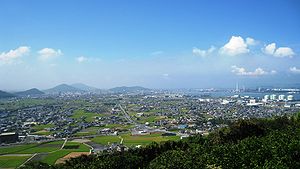
Sakaide is located in north-center Kagawa Prefecture, on the island of Shikoku, facing the Seto Inland Sea to the north. The northern part of the city is flat and low elevation, with parts on reclaimed land. The city includes part of the Shiwaku Islands, including a number of islands which are connected by the Great Seto Bridge. The southern part of the city is hill, and as with many other cities and towns in Kagawa Prefecture, there are many reservoirs. Fuchu Dam constructed on the main stream of the Ayagawa River, creates Lake Fuchu. Mount Iino, nicknamed Sanuki Fuji located on the border between Marugame and Sakaide and is one of the "Sanuki Seven Fujis".[2] The Great Seto Bridge connects the city with Kurashiki, Okayama Prefecture across the Seto Inland Sea.
Neighbouring municipalities edit
Kagawa Prefecture
Climate edit
Sakaide has a Humid subtropical climate (Köppen Cfa) characterized by warm summers and cool winters with light snowfall. The average annual temperature in Sakaide is 15.6 °C. The average annual rainfall is 1439 mm with September as the wettest month. The temperatures are highest on average in January, at around 26.5 °C, and lowest in January, at around 5.4 °C.[3]
Demographics edit
Per Japanese census data,[4] the population of Sakaide has been declining steadily since the 1980s.
| Year | Pop. | ±% |
|---|---|---|
| 1950 | 66,572 | — |
| 1960 | 62,142 | −6.7% |
| 1970 | 64,147 | +3.2% |
| 1980 | 66,290 | +3.3% |
| 1990 | 63,876 | −3.6% |
| 2000 | 59,228 | −7.3% |
| 2010 | 55,631 | −6.1% |
History edit
The area of Sakaide was part of ancient Sanuki Province and has been inhabited since ancient times, with many kofun burial mounds found within the city limits. During the Asuka period the fortress of Kiyama was constructed to guard against the possibility of invasion from Tang dynasty China. During the Edo Period, the area was part of the holdings of Takamatsu Domain, and once flourished as a center for salt production.[5] Following the Meiji restoration, the town of Sakaide was established with the creation of the modern municipalities system on February 15, 1890. It was elevated to city status on July 1, 1942.
Government edit
Sakaide has a mayor-council form of government with a directly elected mayor and a unicameral city council of 20 members. Sakaide, together with Utazu, contributes three members to the Kagawa Prefectural Assembly. In terms of national politics, the city is part of Kagawa 2nd district of the lower house of the Diet of Japan.
Economy edit
Sakaide is an industry city, with shipbuilding and chemical industries, refineries and power stations located in the Bannoshu Rinkai Industrial Park, Hayashida-Agawahama Rinkai Industrial Park and other areas along the coast. Due to its position at the Shikoku end of the Great Seto Bridge, many logistics companies are concentrated are also concentrated in these areas.
Education edit
Sakaide has 12 public elementary schools and five public middle schools operated by the city government, and one each by the national government. The city has three public high schools operated by the Kagawa Prefectural Board of Education, and the prefecture also operates one special education school for the handicapped.
Transportation edit
Railways edit
![]() JR Shikoku - Yosan Line / Seto-Ōhashi Line - Marine Liner
JR Shikoku - Yosan Line / Seto-Ōhashi Line - Marine Liner
- Sanuki-Fuchū - Kamogawa - Yasoba - Sakaide
Highways edit
Sister city relations edit
 - Sausalito, California, USA since February 2, 1988
- - Lansing, Michigan, USA, friendship city since April 12, 1996
Local attractions edit
- Kagawa Prefectural Higashiyama Kaii Setouchi Art Museum , (Kaii Higashiyama`s Art Museum)[6]
- Kandani Shrine
- Mount Iino (Kagawa's Mount Fuji)[7]
- Kiyama (A castle ruin of Yamato court)[8]
- Shōtsu-ji Castle (A castle ruin, Ikoma Chikamasa and Sengoku Hidehisa were commander of the castle)[9]
- Tomb of Emperor Sutoku
- Tennō-ji, 79th temple on the Shikoku Pilgrimage.)
- Shiromine-ji, 81st temple on the Shikoku Pilgrimage
- Fuchu Dam (Lake Fuchu)
- Great Seto Bridge
Gallery edit
-
 Mountain Iino
 -
 Lake Fuchu
 -
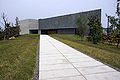 Kaii Higashiyama Art Museum
 -
 Memorial Shinto shrine and mausoleum honoring Emperor Sutoku
 -
 Shiramine Shrine
 -
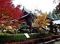 Shiromine-ji Temple
 -
 Kiyama
 -
 Kiyama's gate and stone wall


Festivals edit
- Sakaide Tengu Festival
- Sakaide Salt Festival (May)
- Sakaide Ohashi Festival (August)
Noted people from Sakaide edit
- Juichi Tsushima, former Head of the Japan Olympic Committee
References edit
- ^ "Sakaide city official statistics" (in Japanese). Japan.
- ^ "Mt. Iino (飯野山)". 14 May 2012.
- ^ Sakaide climate data
- ^ Sakaide population statistics
- ^ "塩業資料館" (in Japanese). Sakaide city official. Retrieved 25 July 2019.
- ^ "香川県立東山魁夷せとうち美術館" (in Japanese). Kaii Higashiyama`s Art Museum official. Retrieved 25 July 2019.
- ^ "飯野山" (in Japanese). Sakaide cityofficial. Retrieved 25 July 2019.
- ^ "城山" (in Japanese). 香川のみどり百選. Retrieved 25 July 2019.
- ^ "常盤公園" (in Japanese). 坂出市. Retrieved 25 July 2019.
External links edit
- Sakaide City official website (in Japanese)