


Summary
Salmi (Russian: Салми; Finnish and Karelian: Salmi, lit. inlet) is a rural locality (a settlement) in Pitkyarantsky District of the Republic of Karelia, Russia. Municipally, it is incorporated within and serves as the administrative center of Salminskoye Rural Settlement of Pitkyarantsky Municipal District.
Salmi
Салми | |
|---|---|
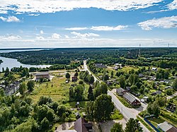 Aerial view on the street of the Svir Divisions | |
Location of Salmi .mw-parser-output .locmap .od{position:absolute}.mw-parser-output .locmap .id{position:absolute;line-height:0}.mw-parser-output .locmap .l0{font-size:0;position:absolute}.mw-parser-output .locmap .pv{line-height:110%;position:absolute;text-align:center}.mw-parser-output .locmap .pl{line-height:110%;position:absolute;top:-0.75em;text-align:right}.mw-parser-output .locmap .pr{line-height:110%;position:absolute;top:-0.75em;text-align:left}.mw-parser-output .locmap .pv>div{display:inline;padding:1px}.mw-parser-output .locmap .pl>div{display:inline;padding:1px;float:right}.mw-parser-output .locmap .pr>div{display:inline;padding:1px;float:left}html.skin-theme-clientpref-night .mw-parser-output .od,html.skin-theme-clientpref-night .mw-parser-output .od .pv>div,html.skin-theme-clientpref-night .mw-parser-output .od .pl>div,html.skin-theme-clientpref-night .mw-parser-output .od .pr>div{background:#000;color:#fff}html.skin-theme-clientpref-night .mw-parser-output .locmap{filter:grayscale(0.6)}@media(prefers-color-scheme:dark){html.skin-theme-clientpref-os .mw-parser-output .locmap{filter:grayscale(0.6)}html.skin-theme-clientpref-os .mw-parser-output .od,html.skin-theme-clientpref-os .mw-parser-output .od .pv>div,html.skin-theme-clientpref-os .mw-parser-output .od .pl>div,html.skin-theme-clientpref-os .mw-parser-output .od .pr>div{background:#000;color:#fff}}  Salmi Location of Salmi  Salmi Salmi (Karelia) | |
| Coordinates: 61°22′07″N 31°52′00″E / 61.36861°N 31.86667°E | |
| Country | Russia |
| Federal subject | Republic of Karelia |
| Administrative district | Pitkyarantsky District[1] |
| Population | |
| • Total | 2,207 |
| • Municipal district | Pitkyarantsky Municipal District |
| • Capital of | Salminskoye Rural Settlement |
| Time zone | UTC+3 (MSK |
| Postal code(s)[4] | 186821 |
| OKTMO ID | 86633420101 |
History edit
The first mention of the Solomenskiy Orthodox pogost in this place dates back to 1500. It was part of the Korelsky district of the Vodskaya Pyatina. Before the capture of these territories by the Swedes in the early 17th century — the Solomians. "Voskresenskaya Solomyanskaya pogost" with borders from modern Uuksu to the Border Guard on the shore of Ladoga and to Suoyarvi in the north.
Since 1617, as part of the Swedish Kingdom, from this period there has been a mass exodus of the local Karelian population to the territory of modern Tver and Vologda regions. In 1632, the Swedes of Salmi presented the rights of the city.
Under the terms of the Nishtadt Peace Treaty in 1721, the lands were returned to the Russian Empire.
At the beginning of the XX century, a steam sawmill, a ceramic factory and tanneries operated in the villages of Miynala, Tulema and a village on the island of Lunkulansaari.
From 1918 to 1939 it was part of Finland.
In the 1935-1970s, the Salma Salmon Hatchery operated.[5]
From 1940 to 1991, it had the status of an urban-type settlement, a large sovkhoz «Salmi» operated.
Attractions edit
- Grave grave of 1100 Soviet soldiers who died during the Soviet-Finnish War (1941-1944) and the grave of Hero of the Soviet Union T. I. Parshutkin.[6] In 1959, a granite obelisk and a sculptural group were installed on the mass grave.[7]
- Church of St. Nicholas the Wonderworker was built in 1826 (now in a dilapidated state).[8]
Sister cities edit
Salmi is twinned with:


References edit
- ^ a b Государственный комитет Российской Федерации по статистике. Комитет Российской Федерации по стандартизации, метрологии и сертификации. №ОК 019-95 1 января 1997 г. «Общероссийский классификатор объектов административно-территориального деления. Код 86 233 000 022», в ред. изменения №278/2015 от 1 января 2016 г.. (State Statistics Committee of the Russian Federation. Committee of the Russian Federation on Standardization, Metrology, and Certification. #OK 019-95 January 1, 1997 Russian Classification of Objects of Administrative Division (OKATO). Code 86 233 000 022, as amended by the Amendment #278/2015 of January 1, 2016. ).
- ^ Russian Federal State Statistics Service (2011). Всероссийская перепись населения 2010 года. Том 1 [2010 All-Russian Population Census, vol. 1]. Всероссийская перепись населения 2010 года [2010 All-Russia Population Census] (in Russian). Federal State Statistics Service.
- ^ "Об исчислении времени". Официальный интернет-портал правовой информации (in Russian). 3 June 2011. Retrieved 19 January 2019.
- ^ Почта России. Информационно-вычислительный центр ОАСУ РПО. (Russian Post). Поиск объектов почтовой связи (Postal Objects Search) (in Russian)
- ^ Карелия: энциклопедия: в 3 т. / гл. ред. А. Ф. Титов. Т. 3: Р — Я. — Петрозаводск: ИД «ПетроПресс», 2011. С. 48—384 с.: ил., карт.
- ^ "Паршуткин Т. И." www.warheroes.ru (in Russian). Archived from the original on 2020-02-24.
- ^ Великая Отечественная война в Карелии: памятники и памятные места. — Петрозаводск, 2015. — 334 с.: ил.
- ^ "Церковь Николая Чудотворца". sobory.ru (in Russian). Archived from the original on 2020-02-21.
External links edit
 Media related to Salmi at Wikimedia Commons