


Summary
Sambava [samˈbav] is a city and commune (commune urbaine; Malagasy: kaominina) at the east coast of northern Madagascar. It is the capital of Sambava District and Sava Region. The population of the commune was 84,039 in as of the 2018 commune census.[2]
Sambava | |
|---|---|
 Sambava Beach | |
 Coat of arms | |
 Sambava Location in Madagascar | |
| Coordinates: 14°16′S 50°10′E / 14.267°S 50.167°E | |
| Country | |
| Region | Sava |
| District | Sambava |
| Government | |
| • Mayor | Judicaël Ramangalaza |
| Area | |
| • Total | 98.9 km2 (38.2 sq mi) |
| Population (2018 census) | |
| • Total | 84,039 |
| • Density | 850/km2 (2,200/sq mi) |
| • Ethnicities | Betsimisaraka |
| Time zone | UTC3 (EAT) |
| Postal code | 208 |
| Climate | Af |
Infrastructure edit
Sambava is located on Route Nationale 5a Ambilobe - Antalaha. It is also the starting point of the National road 3b to Andapa. It has a local airport, regional airport. In addition to primary schooling the town offers secondary education at both junior and senior levels. The town provides access to hospital services to its citizens.[2]
Economy edit
Farming and raising livestock provides employment for 45% and 0.5% of the working population. The most important crop is vanilla, while other important products are coconut and rice. Industry and services provide employment for 0.5% and 53.5% of the population, respectively. Additionally fishing employs 0.5% of the population.[2]
Sambava disposes of white, sandy beaches with several hotels. The Marojejy National Park is close to Sambava on the road to Andapa.
-
 Beach view from Sambava
 -
 Townhall
 -
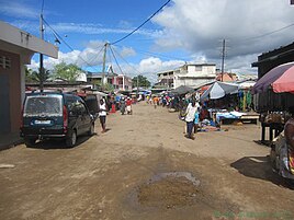 Market road in Sambava
 -
 Women grading vanilla beans
 -
 Beach view from Sambava
 -
 the village of Antsirabe Nord


Commune edit
The municipality of Sambava covers the surrounding 16 fokontany (villages): Ambia, Antohomaro, Ambodisatrana I, Amboisatrana II, Sambava centre, Antaimby, Antsirabe-Nord, Antanifotsy I, Antanifotsy II, Ambariomihambana, Ambohitrakongona, Ampisasahanala, Analamandrorofo, Ambatofitatra, Ampandrozonana, Besopaka, Menagisy, and Soavinandriana.
Sports edit
- FC Joel Sava (regional football champion 2010, 2011, 2015 & 2016).
Climate edit
| Climate data for Sambava | |||||||||||||
|---|---|---|---|---|---|---|---|---|---|---|---|---|---|
| Month | Jan | Feb | Mar | Apr | May | Jun | Jul | Aug | Sep | Oct | Nov | Dec | Year |
| Mean daily maximum °C (°F) | 31 (88) |
31 (88) |
31 (88) |
30 (86) |
29 (84) |
27 (81) |
26 (79) |
26 (79) |
27 (81) |
28 (82) |
29 (84) |
30 (86) |
29 (84) |
| Daily mean °C (°F) | 26 (79) |
26 (79) |
26 (79) |
26 (79) |
24 (75) |
23 (73) |
21 (70) |
21 (70) |
23 (73) |
22 (72) |
24 (75) |
25 (77) |
24 (75) |
| Mean daily minimum °C (°F) | 23 (73) |
23 (73) |
23 (73) |
22 (72) |
21 (70) |
19 (66) |
18 (64) |
18 (64) |
19 (66) |
20 (68) |
21 (70) |
22 (72) |
21 (70) |
| Average rainfall mm (inches) | 342 (13.5) |
257 (10.1) |
284 (11.2) |
227 (8.9) |
183 (7.2) |
183 (7.2) |
176 (6.9) |
195 (7.7) |
100 (3.9) |
109 (4.3) |
132 (5.2) |
219 (8.6) |
2,407 (94.8) |
| Average rainy days (≥ 1 mm) | 16 | 14 | 16 | 15 | 14 | 14 | 17 | 18 | 13 | 13 | 13 | 15 | 178 |
| Mean monthly sunshine hours | 222 | 218 | 216 | 215 | 222 | 191 | 191 | 201 | 215 | 243 | 230 | 240 | 2,604 |
| Source: The Weather Network[3] | |||||||||||||
References and notes edit
14°16′S 50°10′E / 14.267°S 50.167°E