


Summary
Samsonville is a hamlet in the southwestern part of the town of Olive in Ulster County, New York, United States. Bordered to the north by Mombaccus Mountain and Ashokan High Point, it is within the Catskill Park on the southeastern slopes of the high Catskills.
Samsonville, New York | |
|---|---|
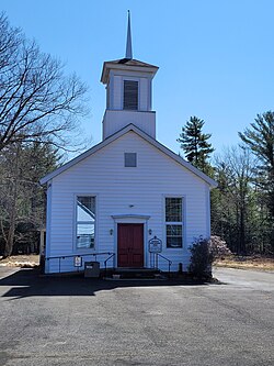 Samsonville United Methodist Church, built 1873 | |
 Samsonville, New York | |
| Coordinates: 41°53′15″N 74°17′39″W / 41.8875929°N 74.2940379°W[1] | |
| Country | United States |
| State | New York |
| County | Ulster |
| Town | Olive |
| Elevation | 856 ft (261 m) |
| Time zone | UTC-5 (Eastern (EST)) |
| • Summer (DST) | UTC-4 (EDT) |
| GNIS feature ID | 964351[1] |
Early history edit
Native American hunters made use of a natural rock shelter beneath a cliff in the area now called Samsonville as early as 2000 BC and possibly as late as 1600 AD. Excavations at the site yielded stone blades, potsherds, arrowheads and spear points.[2] The area that includes Samsonville was once known as Subbeatty land (Mombaccus Mountain was called Subbeatty Mountain). It was included in the Marbletown Commons portion of the Marbletown Patent granted to three trustees by Queen Anne of England in 1703 through her agent, Viscount Cornbury. When Olive was founded in 1823, this section of Marbletown was transferred to the new town.[3][4]
Samsonville developed around a tannery established by Stoddard Hammond and the Palen family of tanners in 1831 below a falls on Mettacahonts Creek.[5][6][7][8]
Town historian Vera Van Steenburgh Sickler wrote: "In 1831, Palen and Hammond built a large tannery in (Palentown) Samsonville. In 1850, after passing through other hands, the tannery became the property of Pratt and Samson."[9] The anonymous author of a 1964 note on Samsonville history in the Kingston Daily Freeman wrote that the tannery had been built in 1831 but gave the names of the original owners as "Hammond and Edson" (Stoddard Hammond was a major tannery owner elsewhere in New York and in Pennsylvania).[10]
In 1848, the tannery was sold to Zadock Pratt, with Henry Samson as operating partner. The area around the tannery had been known as "Palentown" but acquired the name of Samsonville, leaving Palentown as the name of the adjacent area of Rochester, Ulster County, New York.[11]
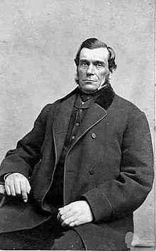
Henry A. Samson edit
Henry Almanzo Samson, for whom the hamlet was named, was born April 4, 1818, in Woodstock, Connecticut, where he learned the tanning trade. In 1853, having established himself as a wealthy local businessman, he was named a Lieutenant Colonel in the 20th Regiment, New York State Militia and the following year was commissioned Brigadier General, 8th Brigade. In 1853, Zadock Pratt gifted his share of the Samsonville tannery to his son George Watson Pratt. Samson became the sole owner in 1856 and also had an interest in four other tanneries. In 1857, he built a grand Italianate villa at 32 West Chestnut Street in Rondout, New York. General Samson performed his Civil War service in New York state, but raised local troops for the Union: "Employees of the big tannery at Samsonville responded well to the patriotic activities of its owner, General Samson of Rondout. 43 of these sturdy men from the back country enlisted in the old 20th and 27 more entered the 120th the following summer."[12] In addition to his tannery interests, Samson was a member of the Board of Directors of the First National Bank of Rondout and the First National Bank of Kingston, one of the original trustees of the Rondout Savings Bank, a founding officer of the Rondout and Oswego Rail Road Company and president of the Washington Ice Company. He died on February 9, 1869, and is interred in Montrepose Cemetery in Rondout, now a district of Kingston.[13]
The name of Samson Mountain, which stands above the upper reaches of Rondout Creek, commemorates Samson the tanner. The peak now known as Ashokan High Point, which looms over Samsonville, was also called Samson by older residents, and is so named on a 1942 United States Coast and Geodetic Survey benchmark at the summit.[14] "Little Ashokan" (also known as "Round Mountain"[15] or "Ashokan Cobble"[16]), a lesser summit below High Point, was known locally as "Samson's Nose."


"The Most Important Town in the Entire Catskill Mountains" edit
Historian Harry Albert Haring wrote that, in its heyday, "Samsonville was the most important town in the entire Catskill Mountains, - its population was the largest, its payroll the greatest."[17] The Civil War created a high demand for the hemlock-tanned sole leather that was the Samsonville tannery's main product. After the war, demand declined, as did the supply of hemlock bark. As bark cutters wiped out the local hemlocks, all the Catskill tanneries eventually closed. Historian David Stradling wrote: “In many locations...when the tanneries closed, the settlements around them closed too. Samsonville, the site of General Henry A. Samson’s large tannery, was once an important town. In 1854, the Samson Tannery employed seventy men, processing a remarkable 31,000 hides a year. By 1930, Haring declared Samsonville nearly a ghost town; it had never found a replacement of the jobs lost when the tannery closed.” [18]
In 1871, an Ulster County directory noted that Samsonville "contains a church, a hotel, three stores, a grist mill, a saw mill, a tannery and about 100 inhabitants."[19] At that time, tanning was still being done in Samsonville by William V.N. Boice & Sons.[20] In 1873, however, the tannery burned down (not for the first time) and was not rebuilt.[21] [22] In 1880, historian Nathaniel Bartlett Sylvester still identified Samsonville as a "thickly-settled neighborhood" but added: "Since the abandonment of the tannery business the importance of the place has declined." Not all was gone: "There are two stores, one by Pratt Shurter and one by Peter Barringer, – Mr. Shurter is also postmaster, – a grist mill, owned by Anthony Shurter. There is also a saw-mill at this place, and a blacksmith."[23]

The Shurter Mills edit
The first known resident of Samsonville was 1812 War veteran John "Captain Jack" Shurter, who served as one of the original Town Officers when Olive was founded in 1823 and as Justice of the Peace.[24] The mills he and his descendants operated for six generations at the top of the Samsonville Falls on Mettacahonts ("Markham") Creek preceded Samson's tanning business and long survived it. The Shurter grist mill ground local buckwheat, wheat and corn, as well as clover for animal feed, until a flood knocked it off its foundation in 1928. That mill ("where the grain is ground, with a rumbling sound, that feeds all Samsonville") was celebrated in "The Tall Pine Tree" ("The Samsonville Song") collected in the 1950s from local residents Celia Krom Kelder and Mary Avery.[25]
The Shurters also operated saw mills that produced excelsior and, later, headings (barrel tops) and shingles, and that side of the business continued after the loss of the grist mill, with a gasoline-powered engine supplementing the sometimes unreliable water power. A turbine installed between the mills provided electric power to Samsonville well before it was available in other remote Catskills communities.[26][27]
Post-tannery years edit
After the tannery era, bluestone quarrying, timber harvesting and shaving hoops from saplings ("hoop poles") to bind the barrels that held Rosendale cement, as well as growing oats and hay, provided employment and income for a reduced population.[28] In 1895, a Rand McNally Atlas gave Samsonville's population as 111.[29] The 1940 census records counted 115 persons in Samsonville.[30]
The tannery, mills, stores, hotel and schoolhouse that once stood in Samsonville are gone, as is Abey Kelder's saloon, celebrated in the local folk song "Kintey Coy at Samsonville"[31] The post office, opened in 1849 with Henry Samson as the first postmaster, closed in 1965, when there were only 50 postal patrons left in the town.[32] A handful of older buildings remain, most notably the Samsonville United Methodist Church, built in 1873.[33] That same year, the Reformed Church of Samsonville, founded in 1851, was taken down and relocated to nearby Krumville.[34][35] Tetta's Market, a gas station, convenience store, pizzeria and former tire store operated since 1952 by four generations of an Italian-American family, is the hamlet's major commercial business.[36]
Public school students in Samsonville are in the Onteora Central School District and attend Bennett Elementary, Onteora Middle and Onteora High School in the Olive hamlet of Boiceville.
Since 1954, Samsonville and Krumville have been served by the volunteers of Olive Fire Department Company No. 4.[37]
References edit
- ^ a b "Samsonville, New York". Geographic Names Information System. United States Geological Survey, United States Department of the Interior.
- ^ "175th Anniversary". December 7, 2022. Retrieved December 7, 2022.
- ^ Vera Van Steenburgh Sickler, History of the Town of Olive, 1823-1973 (New York:privately published), p. 5.
- ^ Sickler, The Town of Olive Through the Years: Part 1, (Kingston, NY: privately published), p. 5.
- ^ The Mettacahonts is a tributary of Rochester Creek, which in turn flows into Rondout Creek, a tributary of the Hudson River. The Munsee name was Magtigkenigkonk, which older locals rendered as Mattekhonk, Matticum, Markham or Markin's Creek or Kill. "Robert S. Grumet, Beyond Manhattan: A Gazetteer of Delaware Indian History Reflected In Modern-Day Place Names, New York State Museum, 2016, p. 19" (PDF).
- ^ "1974 interview with Mrs. Esther Kelsey, née Shurter, by historian Bob Steuding". YouTube.
- ^ "Camp Shady Rest postcard".
- ^ For profiles of some of the prominent members of the Palen family of tanners, see: "Frank W. Norcross, A History of the New York Swamp, New York:The Chiswick Press, 1901, pp. 133, 152-154" (PDF).
- ^ Vera Van Steenburgh Sicker, History of the Town of Olive, 1823-1973 (New York: private published), p. 12.
- ^ "Kingston Daily Freeman" (PDF). September 25, 1964.
- ^ "Tanning in the Catskills". January 20, 2016.
- ^ Plank, Will (1972). "Will Plank, Banners and Bugles: A Record of Ulster County, New York and the Mid-Hudson Region in the Civil War, Madison, WI:Centenniel Press, 1972, p. 116".
- ^ "Chestnut Street Historic District"."History of the Ulster & Delaware".Bowen, Daniel (1893). "Samuel Penniman memoir in "Family of Griffith Bowen..."".Sylvester, Nathaniel Bartlett (1880). "George Watson Pratt bio in Nathaniel Bartlett Sylvester, History of Ulster County, New York, Philadelphia: Everts & Peck, 1880, footnote, p. 156-157".Rondout, New York Freeman, Vol. 6, no. 294, 1864, available via fultonhistory.com
- ^ "Ashokan High Point Hike and Map with picture of benchmark"."USGS 1942 West Shokan topo map".
- ^ Sylvester, Nathaniel Bartlett (1880). "Nathaniel Bartlett Sylvester, History of Ulster County, NY, Philadelphia: Everts and Peck, 1880., p. 301".
- ^ "Caltopo map of Ashokan High Point".
- ^ Haring, Harry Albert (1931). Harry Albert Haring, "Our Catskill Mountains", New York:G.P. Putnam's Sons, 1931, p. 93. ISBN 9781404751248.
- ^ Stradling, David (23 November 2009). David Stradling, Making Mountains: New York City and the Catskills, Seattle:University of Washington Press, p. 35. ISBN 9780295989891.. An article in the September 25, 1964 Kingston Daily Freeman maintained that "The Samson tannery during the seasonal period employed from 50 to 150 hands and included teamsters and numerous teams of horses and oxen.""Kingston Daily Freeman, 9-25-64" (PDF).
- ^ "Hamilton Child, Gazetteer and Business Directory of Ulster County, N.Y. for 1871-2, Syracuse:Hamilton Child, 1871, p.10". 1871.
- ^ Alphonso T. Clearwater, The History of Ulster County, New York, Vol. 2, Kingston: W.J. Van Deusen, 1907, p. 555-6. ISBN 9780788443848. Lemuel Boice was another pioneer tanner in the Catskills. The Olive hamlet of Boiceville was named for him. His descendants carried on tanning, lumber, bluestone, milling and other businesses in the area.
- ^ Clearwater, Alphonso Trumpbour (1907). "Alphonso T. Clearwater (ed.), The History of Ulster County, NY, vol. 1 Kingston, NY:W.J. Van Deusen, 1907, p. 328".
- ^ Henry Samson's half-brother Samuel Penniman referred to a fire of 1868 as being the second time the tannery burned. Bowen, Daniel (1893). "Daniel Bowen, Family of Griffith Bowen..., Jacksonville, FL: Da Costa Printing Co., 1893,p. 259". A reporter in 1964 wrote that Pratt Shurter told him in 1930 that the tannery had burned down in 1864 or 1865, and again in 1873."Kingston Daily Freeman, 9-25-64" (PDF).
- ^ Sylvester, Nathaniel Bartlett (1880). "Nathaniel Bartlett Sylvester, History of Ulster County, New York…, Philadelphia:Everts & Peck, 1880, p. 298".
- ^ "Kingston Daily Freeman, 9-25-64" (PDF).
- ^ Cazden, Haufrecht and Studer, Folk Songs of the Catskills, Albany: SUNY Press, 1982, p. 637.
- ^ "Town of Olive » Historical Quilt". ""Town of Olive 175th Anniversary Celebration," Kingston Daily Freeman, Sunday March 28,1999"., "Kingston Daily Freeman, 9-25-64" (PDF)."1974 interview with Mrs. Esther Kelsey, née Shurter, by historian Bob Steuding". YouTube.
- ^ Sylvester, Nathaniel Bartlett (1880). "Nathaniel Bartlett Sylvester, History of Ulster County, NY, Philadelphia: Everts and Peck, 1880, p. 297".
- ^ "Hudson Valley Guidebook on bluestone quarries". vassar.edu. June 3, 2013.
- ^ "roadsidethoughts.com/ny/samsonville-xx-ulster-1890s.htm".
- ^ "Ancestry.com 1940 census records". Ancestry.com. Retrieved December 7, 2022.
- ^ The lyrics, without melody, were collected from Jerry Van Kleeck and published in Cazden, Haufrecht and Studer, Folk Songs of the Catskills, Albany: SUNY Press, 1982, p. 595.
- ^ "NY Postal History" (PDF). esphs.us. Retrieved December 7, 2022. When ZIP Codes were issued in 1963, Samsonville was assigned 12476 but the hamlet is now included in the Olivebridge ZIP Code, 12461 - the JIMAPCO map of Ulster County, 8th Edition, 1991 still displayed the old Samsonville ZIP.
- ^ "Olivebridge and Samsonville UMC". olivebridge-samsonvilleumcs.weebly.com. Retrieved December 7, 2022.
- ^ "History of Ulster County by Everts & Peck, 1880, p. 300". History of Ulster County, New York. Retrieved December 7, 2022.
- ^ "Kingston Daily Freeman" (PDF). fultonhistory.com. September 25, 1964.
- ^ "Tetta's Market". tettasmarket.com. Retrieved December 7, 2022.
- ^ "History of Olive Fire Department". olivefiredept.org. Retrieved December 7, 2022.
External links edit
- "1875 Inset Map of Samsonville showing Shurter Head Mill and Grist Mill ("G.M."), Saw Mill ("S.M."), Chambers Hotel, Union (i.e., Methodist/Reformed) Church, Schoolhouse, etc". cdm16694.contentdm.oclc.org. Retrieved December 7, 2022.
- "1855 view of Samsonville". gigi.mwa.org. Retrieved December 7, 2022.
- Schenkman, A. J. (31 July 2012). Peter B. Markle, the "Rip Van Winkle" of Samsonville. ISBN 9781614236184.
Notable people edit
- Sufjan Stevens, singer-songwriter
- Vernon Chatman, television producer, writer, voice actor, comedian, and musician
- Sara Lee, bass player, singer, and songwriter