


Summary
For people with the surname, see Sancton (surname).
| Sancton | |
|---|---|
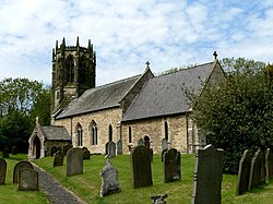 All Saints' Church, Sancton | |
 Sancton Location within the East Riding of Yorkshire | |
| Population | 286 (2011 census)[1] |
| OS grid reference | SE901392 |
| Civil parish |
|
| Unitary authority | |
| Ceremonial county | |
| Region | |
| Country | England |
| Sovereign state | United Kingdom |
| Post town | YORK |
| Postcode district | YO43 |
| Dialling code | 01430 |
| Police | Humberside |
| Fire | Humberside |
| Ambulance | Yorkshire |
| UK Parliament | |
Sancton is a village and civil parish in the East Riding of Yorkshire, England. It is situated approximately 2 miles (3.2 km) south-east of the market town of Market Weighton on the A1034 road. The civil parish is formed by the village of Sancton and the hamlet of Houghton. According to the 2011 UK census, Sancton parish had a population of 286,[1] a reduction of one on the 2001 UK census figure.[2]
History edit
Sancton is known to have been a place where Roman mercenaries were billeted to defend their empire against northern tribes or Anglo-Saxon raiders. A cemetery probably founded by the mercenaries was used until around the year 650.[3] Sancton is mentioned in the Domesday Book as belonging to Robert Malet. The name derives from the Old English sand-tūn, meaning sand town.[4][5]
Besides being the birthplace of Robert, Samuel and Thomas Jackson who were noted Wesleyan preachers, John Wesley himself preached in the village in June 1788.[6][7]
The church dedicated to All Saints was designated a Grade II* listed building in 1967 and is now recorded in the National Heritage List for England, maintained by Historic England.[8]
Notable people edit
- Thomas Jackson, Wesleyan minister, born in Sancton[9]
- Marmaduke Langdale, English Civil War participant, buried at Sancton[10]
References edit
- ^ a b UK Census (2011). "Local Area Report – Sancton Parish (1170211251)". Nomis. Office for National Statistics. Retrieved 24 February 2018.
- ^ "2001 Census: Key Statistics: Parish Headcounts: Area: Sancton CP (Parish)". Neighbourhood Statistics. Office for National Statistics. Retrieved 20 May 2008.
- ^ Allison, Keith John (1976). The East-Riding [sic] of Yorkshire Landscape. London: Hodder & Stoughton. p. 45. ISBN 0340158212.
- ^ "Sancton | Domesday Book". opendomesday.org. Retrieved 21 August 2023.
- ^ Ekwall, Eilert (1960). The concise Oxford dictionary of English place-names (4 ed.). Oxford: Oxford University Press. p. 403. ISBN 0-19-869103-3.
- ^ Hall 1892, p. 132.
- ^ Peach, Howard (2001). Curious tales of old East Yorkshire. Wilmslow: Sigma. p. 46. ISBN 1850587493.
- ^ Historic England. "Church of All Saints (1084105)". National Heritage List for England. Retrieved 16 August 2013.
- ^ Brockbank, James Lindow (1913). The East riding of Yorkshire. Oxford: Clarendon Press. p. 213. OCLC 1042922782.
- ^ Peach, Howard (2001). Curious tales of old East Yorkshire. Wilmslow: Sigma. p. 125. ISBN 1850587493.
- Gazetteer — A–Z of Towns Villages and Hamlets. East Riding of Yorkshire Council. 2006. p. 10.
Sources edit
- Hall, John George (1892). A history of South Cave and of other parishes in the East Riding of the county of York. Hull: Ombler. OCLC 1046574520.
External links edit
- Sancton in the Domesday Book