
KNOWPIA
WELCOME TO KNOWPIA

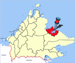
Sandakan District 
Summary
The Sandakan District (Malay: Daerah Sandakan) is an administrative district in the Malaysian state of Sabah, part of the Sandakan Division which includes the districts of Beluran, Kinabatangan, Sandakan, Telupid, and Tongod. The capital of the district is in Sandakan City.
Sandakan District
Daerah Sandakan | |
|---|---|
 Sandakan Municipal Council office. | |
|
Seal | |
 | |
| Coordinates: 5°50′20″N 118°6′55″E / 5.83889°N 118.11528°E | |
| Country | |
| State | |
| Division | Sandakan |
| Capital | Sandakan |
| Government | |
| • President (Sandakan Municipal Council) | Benedict Asmat |
| Area | |
| • Total | 2,266 km2 (875 sq mi) |
| Population (2010) | |
| • Total | 396,290 |
| Website | mps |

There are three members of parliament (MPs) representing the three parliamentary constituencies in the district: Libaran (P.184), Batu Sapi (P.185), and Sandakan (P.186).
Demographics edit
Sandakan district is the third largest of Sabah's 25 districts, with 396,290 inhabitants after Kota Kinabalu and Tawau.[1]
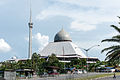
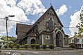
Gallery edit
-
-
-
 Sandakan Calvary Charismatic Church.
 -
 St. Joseph Catholic Church.
 -
 Sandakan Seventh Day Adventist Church.
 -

-
 Gurdwara Sahib Sandakan.
 -
 Sandakan city centre.


See also edit
References edit
- ^ "Population by ethnic group, Local Authority area and state, Malaysia" (PDF). Department of Statistics, Malaysia. 2010. Archived from the original (PDF) on 27 February 2012. Retrieved 5 November 2017.
Further reading edit
- Treacher, W. H (1891). "British Borneo: sketches of Brunai, Sarawak, Labuan, and North Borneo". University of California Libraries. Singapore, Govt. print. dept. p. 190.
- Rutter, Owen (1922). "British North Borneo - An Account of its History, Resources and Native Tribes". Cornell University Libraries. Constable & Company Ltd, London. p. 157.
- Tregonning, K. G. (1965). A History Of Modern Sabah (North Borneo 1881–1963). University of Malaya Press.
External links edit
![]() Media related to Sandakan District at Wikimedia Commons
Media related to Sandakan District at Wikimedia Commons
- (in Malay) Sandakan Municipal Council