
-
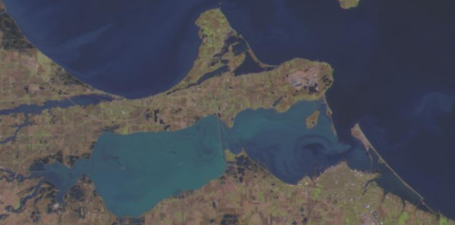 Taken on March 20, 2022 with Resourcesat-2.
 -
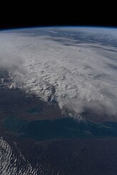 Greenish water flows out of Sandusky Bay (lower left) into Lake Erie in this photo taken on April 12, 2022 from the International Space Station.

KNOWPIA
WELCOME TO KNOWPIA
Sandusky Bay 
Summary
Sandusky Bay is a bay on Lake Erie in northern Ohio, formed at the mouth of the Sandusky River. It was identified as Lac Sandouské on a 1718 French map, with early variations recorded that suggest the name was derived from Native American languages. The Thomas A. Edison Memorial Bridge was constructed across it in the 20th century to connect highways in Erie and Ottawa counties.
History edit
The bay was known to historic and ancient indigenous peoples, including the Iroquoian-speaking Wyandot who dominated this area (they were called the Huron people by French explorers and colonists).
Located in territory claimed by early French explorers, the bay was identified on a 1718 map by Guillaume Delisle as Lac Sandouské (later anglicized as Lake Sandusky). The Indians of the area, primarily Wyandot (Huron) were said to refer to what is known as the Sandusky River and the bay, as well as the general area, as saundustee, meaning "water"[1] or andusti, "cold water".[2] In his 1734 history of New France, Charlevoix transliterated the word as "Chinouski". Sandusky Bay is identified as "Lac (Lake) Sandouské" on a 1718 map by Guillaume DeLisle.[3] The name "L.(Lac) Sandoski" appears on a 1733 map.[4] Sandusky Bay was also called Lac Otsandaské, in another French transliteration of the Wyandot. The Wyandot occupied areas along the river at the Upper and Lower falls.[5]
In 1745, Chief Nicolas of the Wyandot allowed the English to establish a trading post on the north shore of the bay, which they called Fort Sandusky and the French knew as Fort Sandoské. This was the first fort built by Europeans in Ohio Country.[5] The bay has also been referred to as Lake Junandat (derived from a 1754 French fort) and Lake Otsandoské (also related to the Wyandot term for the lake). Lake Sandusky, Sandoski Bay, Sandusky Bay, and Sandusky Lake are also recorded.[6]
French engineer Gaspard-Joseph Chaussegros de Léry passed through this area in 1754, commanding forces to reinforce Fort Detroit at the outbreak of the French and Indian War. He found the ruins of the earlier fort on the north shore of what he referred to as Lac Otsandoské. He had the French Fort Junandat built in 1754 diagonally across from the former Ft. Sandusky.[7]
Geography edit
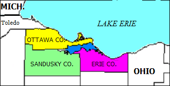
Sandusky Bay is one of the principal bodies of water in northern Ohio.[8] It is situated between Erie,[9] Ottawa,[10] and Sandusky counties in the U.S. state of Ohio and is part of Lake Erie.[11]
According to author Francis Leroy Landacre, it is a "shallow, almost land-locked harbor averaging about twelve feet in depth, some fourteen or fifteen miles in length, with a width of something like two miles."[12] It contains numerous marshes and serves as an entry point for several streams.[12] Sandusky Bay runs from Muddy Creek Bay[13] to Cedar Point,[14] which separates Sandusky Bay from Lake Erie.[12] The Sandusky River drains into the bay at its westernmost point.
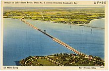
The Thomas A. Edison Memorial Bridge carries Route 2 and Route 269 across Sandusky Bay at its eastern end.[15] This is the only direct highway link between Ottawa and Erie counties. Sandusky Bay can be viewed from Marblehead Lighthouse at Marblehead Lighthouse State Park.
The Sandusky Bay Water Trail was dedicated on June 2, 2007 to provide recreational opportunities along Sandusky Bay.[16] The water of Sandusky Bay is shallow and rarely clear.[12] According to author Tom Cross, "Sandusky Bay is known for great early spring crappie fishing."[17]
Current events edit
On June 14, 2012, the U.S. Customs and Border Protection agency opened Sandusky Bay Station.[18]
Samples of water from Sandusky Bay gathered on July 30 and 31, 2012 showed that invasive Asian carp may have reached Lake Erie. If so, they may adversely affect Lake Erie's $1 billion fishing industry and $10 billion tourism industry.[19]
Wars and rebellions edit
- Queen Anne's War (Old French War). Colonel John Bradstreet sailed sixty long boats into Sandusky Bay and encamped on September 20, 1704.[20]
- War of 1812. United States General William Henry Harrison had troops drag boats across what was known as the de Lery portage from Sandusky Bay to Lake Erie in order to engage British warships in the lake.[20]
- Upper Canada Rebellion. Canadian rebels planned to travel across frozen Lake Erie in the winter from Sandusky Bay to Pelee Island. They were harried by regular British military forces and found that residents had abandoned the island.[21]
Gallery edit


See also edit
Wikimedia Commons has media related to Sandusky Bay.
References edit
- ^ Johnston, John (1858). Vocabularies of the Shawanoese and Wyandott Languages, etc. Retrieved 2017-02-27.
{{cite book}}:|website=ignored (help) - ^ "Wyandot Dictionary" (PDF). Retrieved 2012-05-22.
- ^ "Carte de la Louisiane et du cours du Mississipi [i.e. Mississippi]: dressâee sur un grand nombre de mâemoires entrautres sur ceux de Mr. le Maire / par Guillaume Del'isle del Academie R'le. des Sciences". Memory.loc.gov. Retrieved 2014-03-05.
- ^ "Composite: British Empire in America. / Popple, Henry / 1733". Davidrumsey.com. 1999-02-22. Retrieved 2014-03-05.
- ^ a b Lucy Elliot Keeler (1912-09-15). Old Fort Sandoski of 1745 and the 'Sandusky Country'. Vol. 21. Ohio State Archaeological and Historical Society. pp. 358). Retrieved 2018-07-31.
{{cite book}}:|work=ignored (help) - ^ "Feature Detail Report for: Sandusky Bay". USGS Graphical Names Information System (GNIS). U.S. Department of the Interior -- U.S. Geological Survey. 1979-07-12. Retrieved 2015-06-18.
- ^ Lucy Elliot Keeler (1912-09-15). Old Fort Sandoski of 1745 and the 'Sandusky Country'. Vol. 21. Ohio State Archaeological and Historical Society. pp. 357–378). Retrieved 2018-07-31.
{{cite book}}:|work=ignored (help) - ^ Warren Jenkins (1837). The Ohio Gazetteer, and Traveler's Guide: containing a description of the several towns, townships and counties, with their water courses, roads, improvements, mineral productions... Isaac N. Whiting. p. 1.
- ^ "Welcome to the City of Sandusky, Ohio". Ci.sandusky.oh.us. 2013-08-25. Retrieved 2015-06-18.
- ^ "The great history of our area". Travel Lake Erie. Retrieved 2015-06-18.
- ^ "SOUTH SHORE OF LAKE ERIE SANDUSKY BAY 10 (Marine Chart : US14842_P1171) | Nautical Charts App". Gpsnauticalcharts.com. Retrieved 2015-06-18.
- ^ a b c d Francis Leroy Landacre (1908). The Protozoa of Sandusky Bay and Vicinity. Society.
- ^ [1] Archived December 26, 2011, at the Wayback Machine
- ^ "Fun on Lake Erie at". Cedar Point. 2012-03-21. Retrieved 2015-06-18.
- ^ "Sandusky Bay (in Ottawa County, OH)". Ohio.hometownlocator.com. Retrieved 2015-06-18.
- ^ "The Sandusky Bay Water Trail". Ci.sandusky.oh.us. Retrieved 2015-06-18.
- ^ Tom Cross (2008). Fishing Ohio: An Angler's Guide to Over 200 Fishing Spots in the Buckeye State. Globe Pequot Press. p. 331. ISBN 978-0-7627-4326-1.
- ^ "Toledo Blade". Toledo Blade. 2012-06-14. Retrieved 2015-06-18.
- ^ [2] Archived September 22, 2012, at the Wayback Machine
- ^ a b Denis Larionov & Alexander Zhulin (1912-09-15). "Ohio Archæological and Historical Quarterly". Ohio State Archaeological and Historical Society. pp. 33 of 44). Retrieved 2015-06-18.
- ^ "Author's imagination stoked by Lake Erie tales". Windsor Star. 2008-11-24. Archived from the original on 2012-08-25. Retrieved 2015-06-18.
41°28′13″N 82°51′18″W / 41.47028°N 82.85500°W