


Summary
Sangareddy district, is a district in the Indian state of Telangana. This district contains a part of the Hyderabad Metropolitan Region.[2]Sangareddy (formerly known as Sangareddy Peta) is the district headquarters of the district. It was named after the ruler Sanga, the son of queen Shankaramba, who was the ruler of Medak during the period of Nizams.[3] The district shares boundaries with Medak, Medchal, Vikarabad, Kamareddy and Rangareddy districts and with the state boundary of Karnataka.
Sangareddy district | |
|---|---|
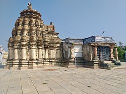 Ramalingeshwara temple, Nandikandi | |
 Location in Telangana | |
 Sangareddy district | |
| Coordinates (Sangareddy): 17.780532, 77.892057 | |
| Country | |
| State | Telangana |
| Mandals | 28 |
| Established | 11 October 2016[1] |
| Founded by | Government of Telangana, |
| Headquarters | Sangareddy |
| Revenue Divisions | 04 |
| Government | |
| • Type | Zilla Panchayath |
| • Body | Sangareddy Zilla Panchayath |
| • Collector | Dr. A Sharath IAS |
| Area | |
| • Total | 4,996.46 km2 (1,929.14 sq mi) |
| Population (2015) | |
| • Total | 1,526,026 |
| • Density | 310/km2 (790/sq mi) |
| Time zone | UTC+05:30 (IST) |
| Vehicle registration | TS 15 |
| Major highways | |
| Website | sangareddy |
Geography edit
The district is spread over an area of 4,464.87 square kilometres (1,723.90 sq mi).[4]
Demographics edit
At the time of the 2011 census, Sangareddy district had a population of 1,526,026. Sangareddy has a sex ratio of 965 females per 1000 males and a literacy rate of 64.03%. 194,674 (12.76%) were under 6 years of age. 529,965 (34.73%) lived in urban areas. Scheduled Castes and Scheduled Tribes made up 276,595 (18.13%) and 86,410 (5.66%) of the population respectively.[6]
At the time of the 2011 census, 71.24% of the population spoke Telugu, 15.46% Urdu, 5.05% Lambadi, 3.76% Kannada, 1.74% Hindi and 1.32% Marathi as their first language.[7]
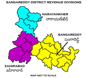
Administrative divisions edit
The district has four revenue divisions of Narayankhed, Sangareddy, Zaheerabad, Andole–Jogipet which are sub-divided into 28 mandals.[2] Dr. A Sharath IAS is the present collector of the district.[8]
Mandals edit
| S.No. | Sangareddy revenue division | Narayankhed revenue division | Zaheerabad revenue division | Andole-Jogipet |
|---|---|---|---|---|
| 1 | Ameenpur | Kalher | Jharasangam | Andole |
| 2 | Gummadidala | Manoor | Mogudampally | Pulkal |
| 3 | Hathnoora | Nagilgidda | Nyalkal | Chowtakur |
| 4 | Jinnaram | Narayankhed | Raikode | Vatpally |
| 5 | Kandi | Sirgapoor | Zahirabad | |
| 6 | Kondapur | Nizampet | Kohir | |
| 7 | Munipally | Kangti | ||
| 8 | Patancheru | Tadkal | ||
| 9 | Ramachandrapuram | |||
| 10 | Sadasivpet | |||
| 11 | Sangareddy |
See also edit
References edit
- ^ District Sangareddy, Government of Telangana | India
- ^ a b "Sangareddy district" (PDF). New Districts Formation Portal. Retrieved 11 October 2016.
- ^ "About District- District Sangareddy, Government of Telangana". Telangana State Portal. Government of Telangana. Retrieved 2 January 2024.
- ^ "New districts". Andhra Jyothy.com. 8 October 2016. Retrieved 8 October 2016.
- ^ "Population by Religion - Andhra Pradesh". Census of India. Registrar General and Census Commissioner of India. 2011.
- ^ "Know your district Plan your district - Sangareddy" (PDF). trac.telangana.gov.in. Telangana State Remote Sensing Applications Centre.
- ^ a b "Table C-16 Population by Mother Tongue: Andhra Pradesh". Census of India. Registrar General and Census Commissioner of India.
- ^ "K Chandrasekhar Rao appoints collectors for new districts". Deccan Chronicle. 11 October 2016. Retrieved 13 October 2016.
External links edit